- 12.15 Leominster 1927
- 17.07 Kington 1927
- 21.06 Bromyard 1902
- 33.16 Hereford available for 2 dates: 1885
 ; 1903
- 41.04 Ledbury 1926
- 51.04 Ross-on-Wye (N) 1927
- 51.08 Ross-on-Wye (S) 1927
- 07.04 Whitchurch 1899
- 12.14 Oswestry 1901
- 13.02 Ellesmere 1924
- 16.02 Market Drayton 1900
- 19.02 Oswestry (South) 1900
- 21.03 Wem 1924
- 26.05 Llanymynech 1900
- 31.05 Newport 1900
- 34.07 Shrewsbury (North) 1900
- 34.10 Shrewsbury (West) available for 2 dates: 1900; 1925
- 34.11 Shrewsbury (East) available for 2 dates: 1900; 1925
- 34.14 Meole Brace available for 2 dates: 1900; 1925
- 36.07 Trench 1901
- 36.09 Wellington available for 2 dates: 1901; 1925
- 36.10 Hadley 1901
- 36.11 Wrockwardine Wood, Wombridge & St Georges 1901
- 36.12 Granville Colliery & Priorslee Hall 1901
- 36.14 Ketley 1901
- 36.15 Oakengates (South) 1901
- 43.02 Lawley 1901
- 43.03 Malins Lee & Dark Lane 1901
- 43.06 Horsehay & Dawley 1901
- 43.07 Dawley Magna & Stirchley 1901
- 43.10 Coalbrookdale & Lightmoor available for 2 dates: 1901; 1925
- 43.11 Madeley Court 1901
- 43.13 Buildwas Abbey & Benthall Edge 1901
- 43.14 Ironbridge available for 3 dates: 1882 ; 1901; 1925
- 43.15 Madeley (South) & Blists Hill available for 2 dates: 1901; 1925
- 44.01 Shifnal 1901
- 50.08 Much Wenlock 1925
- 51.02 Broseley 1901
- 51.03 Coalport 1925
- 56.09 Church Stretton 1901
- 58.12 Bridgnorth 1901
- 62.08 Bishop's Castle & Clun 1901
- 70.04 Craven Arms & Stokesay 1902
- 78.08 Ludlow 1901
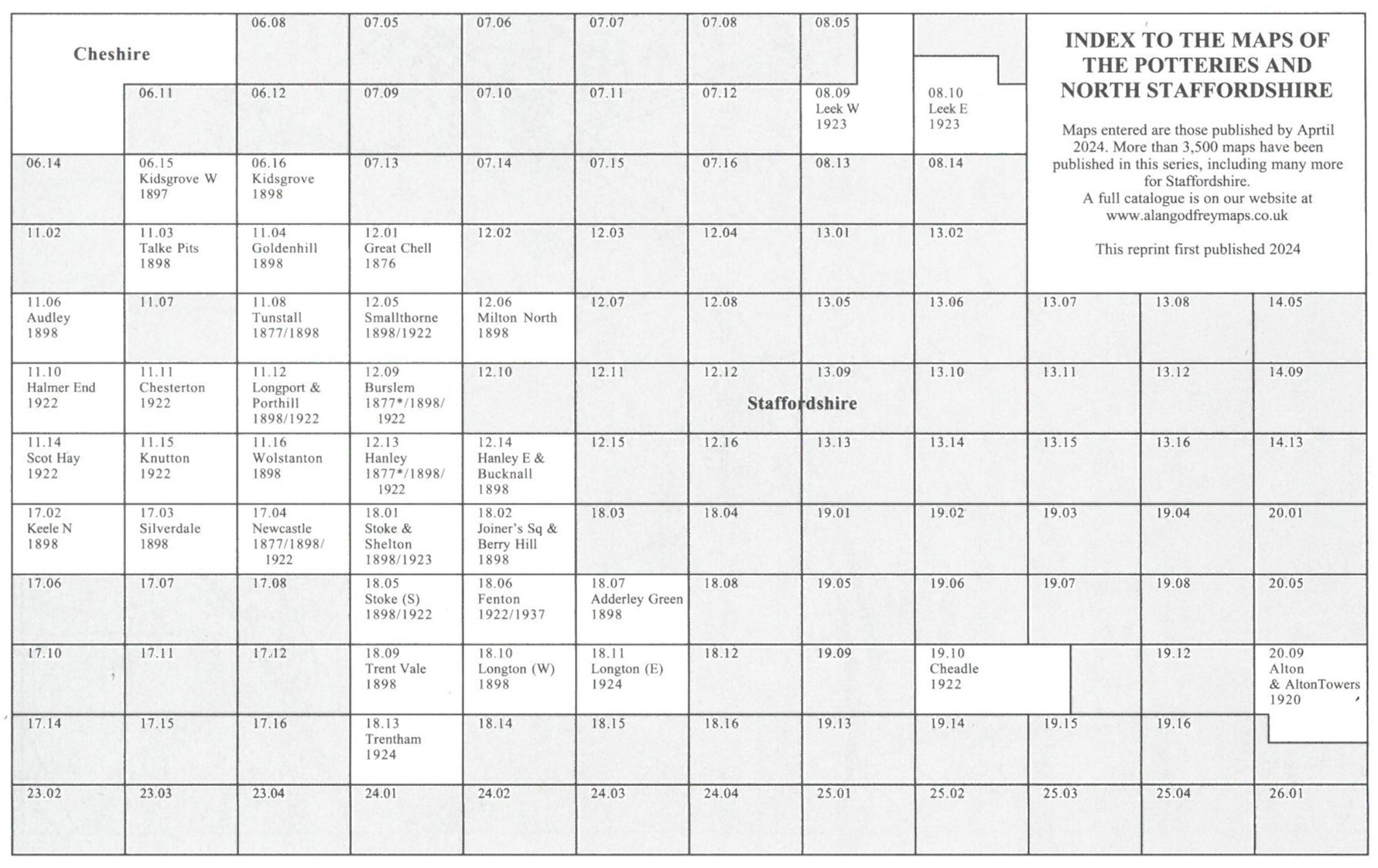
- 06.15 Kidsgrove (West) 1897
- 06.16 Kidsgrove 1898
- 08.09 Leek (West) 1923
- 08.10 Leek (East) 1923
- 11.03 Talke Pits 1898
- 11.04 Tunstall (North) & Goldenhill 1898
- 11.06 Audley 1898
- 11.08 Tunstall Available for 2 dates: 1877; 1898
- 11.10 Halmer End & Alsagers Bank 1922
- 11.11 Chesterton 1922
- 11.12 Longport & Porthill Available for 2 dates: 1898; 1922
- 11.15 Knutton & Apedale Iron Works 1922
- 11.16 Wolstanton 1898
- 12.01 Great Chell 1876
- 12.05 Smallthorne & East Tunstall Available for 2 dates: 1898; 1922
- 12.06 Milton (North) 1898
- 12.09 Burslem & Cobridge available for 3 dates: 1877; 1898; 1922
- 12.13 Hanley & Etruria available for 3 dates: 1877 ; 1898; 1923
- 12.14 Hanley (East) & Bucknall 1898
- 17.02 Keele (North) 1898
- 17.03 Silverdale 1898
- 17.04 Newcastle-under-Lyme Available for 3 dates: 1877; 1898; 1922
- 18.01 Stoke upon Trent available for 2 dates: 1898; 1923
- 18.02 Hanley SE (Joiner's Sq & Berry Hill) 1898
- 18.05 Stoke-upon-Trent (South) available for 2 dates: 1898; 1923
- 18.06 Fenton Available for 2 dates:1922; 1937
- 18.07 Longton (Adderley Green) 1898
- 18.09 Trent Vale & Hanford 1898
- 18.10 Longton (West) 1898
- 18.11 Longton (East) 1922
- 18.13 Trentham 1924
- 19.10 Cheadle 1922
- 20.09 Alton & Alton Towers 1920
- 24.14 Stone (North) 1900
- 30.02 Stone (South) 1900
- 32.02 Uttoxeter 1900
- 37.11 Stafford Available for 2 dates: 1879; 1900
- 40.12 Burton-on-Trent (N) available for 2 dates: 1882 ; 1900
- 40.16 Burton-on-Trent (S) available for 2 dates: 1882 ; 1900
- 41.09 Burton-on-Trent (E) with Winshill & Stapenhill 1882
- 45.08 Rugeley (North) 1921
- 45.12 Rugeley (South) 1921
- 50.03 Penkridge 1921
- 51.10 Cannock (North) 1902
- 51.13 Cannock (South) 1902
- 52.15 Lichfield 1921
- 57.08 Brownhills & Ogley Hay 1901
- 57.11 Pelsall (North) 1883
- 57.12 Shire Oak & Catshill (incl Walsall Wood Colliery) 1901
- 57.14 Bloxwich 1902
- 57.15 Pelsall (South) 1901
- 57.16 Walsall Wood 1901
- 59.11 Tamworth 1900
- 62.02 Wolverhampton (Bushbury) 1914
- 62.05 Tettenhall 1900
- 62.06 Wolverhampton NW 1901 Available for 2 dates: 1901; 1914
- 62.07 Wolverhampton NE & Heath Town Available for 3 dates: 1885; 1901; 1913
- 62.08 Willenhall (NW) & Wednesfield Available for 2 dates: 1901; 1913
- 62.09 Finchfield & Wightwick 1914
- 62.10 Wolverhampton SW Available for 2 dates: 1901; 1914
- 62.11 Wolverhampton SE Available for 3 dates: 1885; 1901; 1913
- 62.12 Willenhall (SW) Available for 2 dates: 1901; 1913
- 62.14 Upper Penn 1901
- 62.15 Ettingshall Available for 2 dates: 1901; 1913
- 62.16 Bilston Available for 3 dates: 1884 ; 1903; 1913
- 63.02 Leamore & South Bloxwich 1900
- 63.03 Rushall 1913
- 63.05 Willenhall (NE) available for 2 dates: 1885; 1913
- 63.06 Walsall (NW) Available for 2 dates: 1901; 1913
- 63.07 Walsall (NE) 1913
- 63.09 Willenhall SE & Darlaston Green Available for 3 dates: 1888; 1901; 1913
- 63.10 Walsall (SW) Available for 2 dates: 1901; 1913
- 63.11 Walsall (SE) Available for 2 dates: 1901; 1913
- 63.13 Darlaston & King's Hill Available for 2 dates: 1901; 1913
- 63.14 Bescot Available for 2 dates: 1901; 1913
- 63.15 The Delves 1912
- 67.02 Penn Common 1900
- 67.03 Sedgley (NE) & Deepfields 1901
- 67.04 Bradley & Coseley available for 2 dates: 1901; 1913
- 67.05 Wombourne 1900
- 67.06 Sedgley (West) Available for 2 dates: 1900; 1938
- 67.07 Sedgley (SE) & West Coseley Available for 2 dates: 1901; 1938
- 67.08 Tipton available for 3 dates: 1884; 1904; 1914
- 67.10 Gornalwood & Himley Coalfield 1901
- 67.11 Gornal & Wren's Nest 1901
- 67.12 Dudley Castle & Tipton Green available for 2 dates: 1901; 1913
- 67.13 Wall Heath 1900
- 67.14 Shut End & Tansey Green 1903
- 67.15 Dudley (West) Available for 2 dates: 1881 ; 1901
- 67.16 Dudley Available for 3 dates: 1882 ; 1901; 1914
- 68.01 Wednesbury Available for 2 dates: 1902; 1913
- 68.02 Mesty Croft Available for 3 dates: 1888; 1902; 1913
- 68.03 Tame Bridge 1901
- 68.04 Great Barr 1901
- 68.05 Great Bridge & Toll End 1902
- 68.06 West Bromwich (North) Available for 2 dates: 1885 ; 1938
- 68.08 Hamstead 1913
- 68.09 Greets Green Available for 2 dates: 1902; 1913
- 68.10 West Bromwich Available for 4 dates: 1886 ; 1902; 1913; 1938
- 68.11 Sandwell Hall 1902
- 68.12 Handsworth Wood 1902
- 68.13 Brades Village 1902
- 68.14 Oldbury & Spon Lane Available for 3 dates: 1904; 1913; 1938
- 68.15 The Hawthorns Available for 2 dates: 1886; 1913
- 69.09 Perry Barr 1902
- 71.01 Kingswinford 1901
- 71.02 Brockmoor & Bromley 1901
- 71.03 Round Oak Available for 3 dates: 1901;1914
- 71.04 Netherton & Springfield Available for 3 dates: 1901; 1914
- 71.05 Wordsley 1901
- 71.06 Brierley Hill (West) & Brettell Lane Available for 2 dates: 1882; 1901
- 71.07 Brierley Hill (East) & Quarry Bank Available for 2 dates: 1882; 1901
- 71.08 Cradley Heath, Old Hill & Dudley Wood Available for 3 dates: 1881; 1901; 1914
- 72.01 Whiteheath Gate Available for 2 dates: 1902; 1914;
- 72.02 Langley Green & South Oldbury Available for 3 dates: 1902; 1914; 1938
- 72.03 Smethwick Available for 3 dates: 1901; 1913; 1938
- 72.05 Rowley Regis & Blackheath 1902
- 72.06 Warley 1902
- 72.07 Bearwood & Hagley Road 1903 Available for 2 dates: 1903; 1913
- 04.11 Four Oaks 1902
- 04.15 Sutton Coldfield 1913
- 07.16 Handsworth 1913
- 08.03 Wylde Green 1913
- 08.07 Erdington (Chester Rd) 1913
- 08.10 Erdington (West) & Stockland Green 1913
- 08.11 Erdington (East) 1913
- 08.13 Aston Manor Available for 2 dates: 1913; 1938
- 08.14 Gravelly Hill Available for 3 dates: 1886 ; 1902; 1913
- 08.15 Bromford Bridge 1913
- 11.09 Nuneaton 1923
- 11.13 Chilvers Coton & Attleborough 1902
- 13.04 Birmingham (Winson Green & Hockley) Available for 3 dates: 1888; 1903; 1914
- 13.08 Birmingham (West) incl Ladywood Available for 2 dates: 1887 ; 1914
- 13.11 Harborne 1901 Available for 3 dates: 1901; 1914
 ; 1938
- 13.12 Edgbaston 1887 Available for 3 dates: 1887 ; 1901; 1914
- 13.15 Harborne (South) 1901
- 13.16 Bournbrook & Birmingham University Available for 2 dates: 1902-11; 1914
- 14.01 Birmingham (North) Available for 2 dates: 1902; 1913
- 14.02 Birmingham (Saltley) Available for 3 dates: 1886 ; 1902; 1913
- 14.03 Ward End 1902
- 14.05 Central Birmingham Available for 4 dates: 1888 ; 1902; 1902-11; 1913
- 14.06 Birmingham (East) Available for 3 dates: 1888 ; 1901; 1913
- 14.07 Stechford 1902
- 14.09 Birmingham (South) Available for 2 dates: 1888; 1913
- 14.10 Small Heath & Sparkbrook Available for 3 dates: 1888; 1903; 1913
- 14.11 South Yardley & Hay Mills 1903
- 14.13 Moseley Available for 2 dates: 1903; 1913
- 14.14 Sparkhill & Greet Available for 4 dates: 1887; 1903; 1913; 1938
- 14.15 Acocks Green & South Yardley Available for 2 dates: 1902-11; 1913
- 17.05 Bedworth 1923
- 19.01 King's Heath 1937
- 19.05 Alcester Lane's End & Brandwood End 1937
- 19.10 Yardley Wood & Shirley 1914
- 19.12 Solihill 1902
- 21.08 Coventry (North) 1912
- 21.11 Coventry (West) 1904-11
- 21.12 Coventry Available for 2 dates: 1887 ; 1905
- 21.16 Coventry (South) 1912
- 26.10 Kenilworth 1903
- 28.03 Rugby (North) 1923
- 28.07 Rugby (South) 1923
- 33.10 Warwick North 1923
- 33.11 Leamington Spa 1923
- 33.14 Warwick South 1923
- 33.15 Leamington Spa (South) 1923
- 44.06 Stratford on Avon 1885
- 04.09 Wollaston 1901
- 04.10 Stourbridge (North) & Amblecote Available for 2 dates: 1901; 1914
- 04.11 Lye Available for 2 dates: 1901; 1914
- 04.12 Cradley (South) 1901
- 04.14 Stourbridge (South) & Oldswinford Available for 2 dates: 1901; 1914
- 04.16 Halesowen (West) Available for 2 dates: 1901; 1914
- 05.01 See Staffs Sheet 72.01
- 05.02 See Staffs Sheet 72.02
- 05.09 Coombeswood 1914
- 05.10 Quinton 1902
- 05.13 Halesowen (East) Available for 2 dates: 1902; 1013
- 08.15 Kidderminster 1921
- 09.02 Pedmore 1921
- 10.03 Griffin's Hill 1902
- 10.04 Selly Oak & Bournville Available for 3 dates: 1903; 1914; 1937
- 10.07 Northfield (North) 1903
- 10.08 Lifford, Cotteridge & Bournville Available for 2 dates: 1903; 1914
- 10.11 Northfield (South) 1903
- 10.12 King's Norton 1903
- 10.14 Longbridge 1937
- 11.02 Hall Green 1903
- 14.01 Bewdley 1926
- 14.10 Stourport 1901
- 15.16 Bromsgrove 1926
- 16.11 Alvechurch 1903
- 19.01 Tenbury 1902
- 22.14 Droitwich (North) 1901
- 23.07 Redditch (West) 1903
- 23.08 Redditch (East) 1903
- 29.02 Droitwich (South) 1901
- 33.03 Worcester (NW) 1902
- 33.04 Worcester (NE) 1902
- 33.07 Worcester (SW) 1902
- 33.08 Worcester (SE) 1902
- 39.12 Great Malvern & West Malvern 1926
- 39.16 Malvern: The Wyche 1926
- 40.05 Malvern Link 1926
- 40.09 Great Malvern (East) 1926
- 42.15 Evesham (North) 1903
- 46.04 Malvern Wells 1903
- 49.03 Evesham & Bengeworth 1903
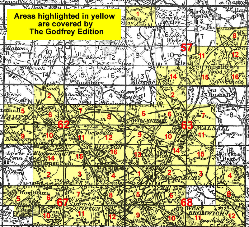
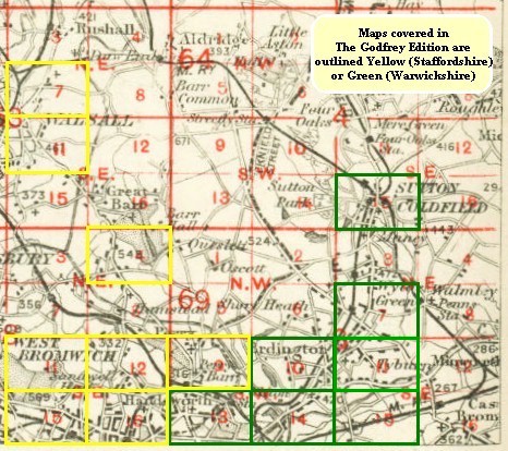
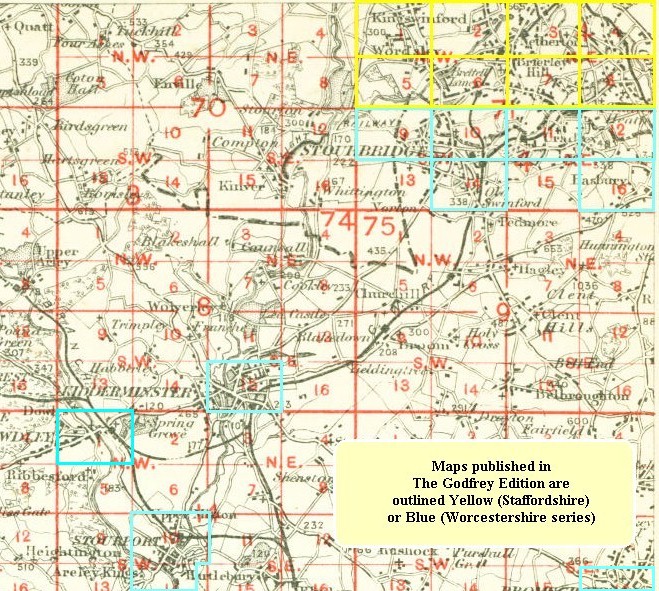
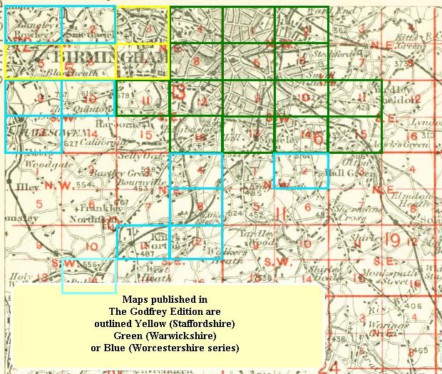
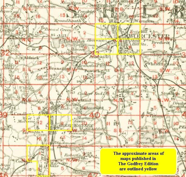
The West Midlands area around Birmingham is very complicated, as many places have changed from one county to another over the years. You might find these 4 index grids useful:
And these grids might help for other parts of the West Midlands:

Alan Godfrey Maps, Prospect Business Park, Leadgate, Consett, DH8 7PW. Tel 01207 583388
The Godfrey Edition / sales@alangodfreymaps.co.uk / 25 November 2024