Old Ordnance Survey Maps of Birmingham

  • These detailed maps normally cover an area of about one and a half miles by one mile. Each map includes an introduction.
  • They are available through our On-line Mapshop

  • Here are the details of maps for King's Heath:

  • Warwicks Sheet 19.01 King's Heath 1937 - published 2016; intro by Alan Godfrey. ISBN.978-1-84784-972-4

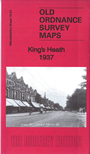
    This detailed map covers King's Heath, just south of Birmingham, including the southern part of Moseley.

    Features include St Agnes church, All Saints church, St Hugh's church, Kingsfield House, Kingsway Cinema, Uffculme, Highbury, King's Heath Park, Moor Green, The Priory, railway with Hazelwell and King's Heath stations, tramway, Highbury Park, Open Air School, Billesley Hotel etc. Extracts from a 1907 directory are included on the reverse.

    The map links up with sheets 14.13 Moseley to the north, 19.05 Alcester Lane's EndWorcestershire 10.04 Selly Oak to the west, 11.02 Hall Green to the east.


  • For a full list of maps of Warwickshire, please go to the Birmingham page or (for areas outside Birmingham) to the Warwickshire page.
  • You can order maps direct from our On-line Mapshop. For other information and prices, and other areas, go to The Index Page.
  • Maps in the Godfrey Edition are taken from the 25 inch to the mile map and reduced to about 15 inches to the mile. For a full list of maps for England, return to the England page.
    Alan Godfrey Maps, Prospect Business Park, Leadgate, Consett, Co Durham, DH8 7PW / sales@alangodfreymaps.co.uk / 29 June 2020