
Old Ordnance Survey Maps of Shropshire
These detailed maps normally cover an area of about one and a half miles by one mile. Each map includes an introduction.
They are available through our On-line Mapshop
 Here are the details of maps for Wrockwardine Wood:
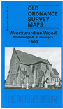
Shropshire Sheet 36.11 Wrockwardine Wood, Wombridge & St Georges 1901 - published 1991; intro by Barrie Trinder. ISBN.978-1-84151-497-0 
This busy map of Wrockwardine Wood covers the area from The Whitehorse Inn Public House and Teagues Bridge to Market Street and St George's Church in the South. The railway line and station feature on the map as does Newyard Engineering Works,Gas Works, St Mary & St Leonard's Church, Wombridge Iron Works (disused) and Shropshire Iron Works. There are also numerous old coal shafts and quarrys on shown on the map. On the reverse of the map we include an extract from a street directory.
This map links up with Shropshire Sheet 36.07 Trench to the North, 36.10 Hadley to the West and 36.15 Oakengates (South) to the South
Follow this link for a complete list of our Shropshire or Telford maps.
You can order maps direct from our On-line Mapshop.
For other information and prices, and other areas, go to The Index Page.
Maps in the Godfrey Edition are taken from the 25 inch to the mile map and reduced to about 15 inches to the mile.
For a full list of maps for England, return to the England page.
The Godfrey Edition / sales@alangodfreymaps.co.uk / 30 January 2018