
Old Ordnance Survey Maps of Shropshire
We have a range of detailed maps for Shropshire towns and we also cover the whole county at the Inch to the Mile scale.
All maps are available from our On-line Mapshop.
Shropshire (or Salop) County Council was formed in 1889. Since 2009 the county has been covered by two unitary authorities,
Shropshire and Telford
See This Page for a summary of the county's local government history.
 These are the maps we publish for Shropshire (excepting Telford):
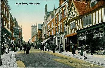
07.04 Whitchurch 1899 published 2003; intro by Derrick Pratt
12.14 Oswestry 1901 published 1991; intro by Barrie Trinder
13.02 Ellesmere 1924 published 2003; intro by Derrick Pratt
16.02 Market Drayton 1900 published 2003; intro by Barrie Trinder
19.02 Oswestry South 1901 published 1991; intro by Barrie Trinder
21.03 Wem 1924 published 2004; intro by Derrick Pratt
26.05 Llanymynech 1900 published 2005; intro by Derrick Pratt
31.05 Newport 1900 published 2012; intro by Derrick Pratt
34.07 Shrewsbury North 1900 published 1995; intro by Barrie Trinder
34.10a Shrewsbury West 1900 published 1989; intro by Barrie Trinder
34.10b Shrewsbury West 1925 published 2024; intro by Barrie Trinder
34.11a Shrewsbury East 1900 published 1989; intro by Barrie Trinder
34.11b Shrewsbury East 1925 published 2024; intro by Barrie Trinder
34.14a Meole Brace 1900 published 1990; intro by Alan Godfrey
34.14b Meole Brace 1925 published 2024; intro by Barrie Trinder
44.01 Shifnal 1901 published 2004; intro by Barrie Trinder
51.02 Broseley 1901 published 1992; intro by Barrie Trinder
50.08 Much Wenlock 1925 published 2005; intro by Barrie Trinder
56.09 Church Stretton 1901 published 2009; intro by Derrick Pratt
58.12 Bridgnorth 1901 published 1992; intro by Barrie Trinder
62.08 Bishops Castle & Clun 1901 published 1993; intro by Barrie Trinder
70.04 Craven Arms & Stokesay 1902 published 2003; intro by Barrie Trinder
78.08 Ludlow 1901 published 1990; intro by Barrie Trinder
For maps of the Telford area go to the Telford page.
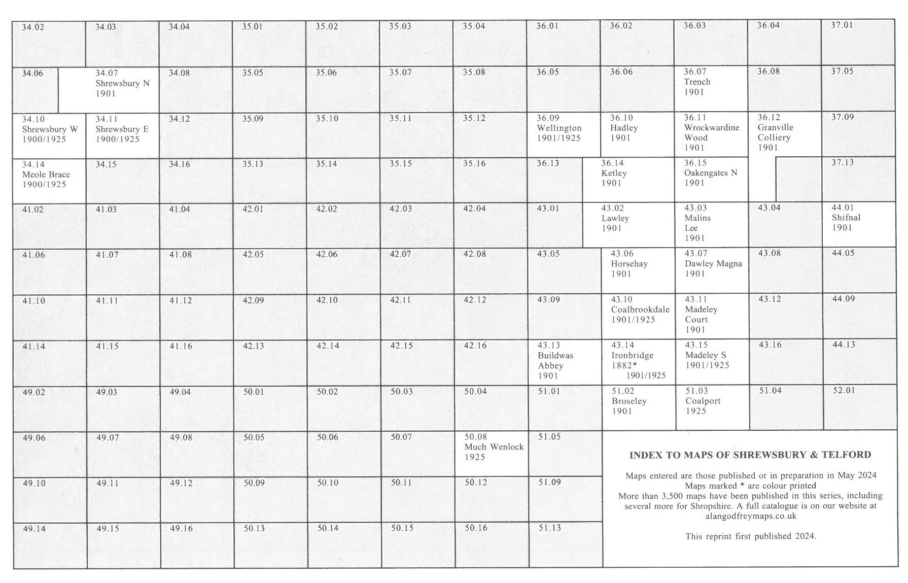
Here is an Index grid for Shrewsbury and Telford
We cover the whole of Shropshire in our Inch to the Mile map series. These are the principal sheets for the county:
122 Whitchurch, Nantwich & English Maelor 1905 - published 2001; intro by Alan Crosby. Includes a map of Holt & Farndon
137 Oswestry, Lanfyllin & District 1904 - published 2001; intro by Derrick Pratt. Includes a map of Llanfyllin
138 North Shropshire Plain 1904 - published 2002; intro by Derrick Pratt. Includes a map of Ruyton-XI-Town
152 Shrewsbury & The Wrekin 1904 - published 2003; intro by Barrie Trinder. Includes a map of Acton Burnell
153 Wolverhampton & Ironbridge 1898 - published 2001; intro by Barrie Trinder. Includes a map of Penkridge
166 Church Stretton & Wenlock Edge 1906 - published 2002; intro by Barrie Trinder. Includes a map of Wistanstow
167 Dudley, Bridgnorth & District 1898 - published 2008; intro by Barrie Trinder. Includes a map of Tysull
181 Ludlow, Tenbury & District 1897 - published 2005; intro by Barrie Trinder. Includes a map of Woofferton
182 Wyre Forest, Droitwich & Kidderminster 1907 - published 2002; intro by John Boynton. Includes a map of Cleobury Mortimer
For a full list of our one inch maps, plus index maps, go to the One Inch page
 Most maps in the Godfrey Edition are taken from the 25 inch to the mile map and reduced to about 15 inches to the mile.
For a full list of English maps, return to the England page
You can order maps direct from our On-line Mapshop.
This list shows all our maps for the area. We try to keep a full range in print but inevitably some titles fall out of print from time to time.
These are noted in our On-line Mapshop.
Most maps in the Godfrey Edition are taken from the 25 inch to the mile map and reduced to about 15 inches to the mile.
For a full list of English maps, return to the England page
You can order maps direct from our On-line Mapshop.
This list shows all our maps for the area. We try to keep a full range in print but inevitably some titles fall out of print from time to time.
These are noted in our On-line Mapshop.
Alan Godfrey Maps, Prospect Business Park, Leadgate, Consett, DH8 7PW. Tel 01207 583388
The Godfrey Edition / sales@alangodfreymaps.co.uk / 30 August 2024
 These are the maps we publish for Shropshire (excepting Telford):