We have published more than 1,800 maps in our series of Old Ordnance Survey Map reprints, including a good groups for Shropshire. The maps are highly detailed. They are taken from the OS 1:2,500 (or 25 inch) maps and reduced to about 15 inches to the mile. Each covers an area of a mile and a half by a mile. They show streets with individual houses, tram tracks, railway tracks and even signals, factories, wharves and such details as fountains and water troughs. They will provide hours of fascination for historians and genealogists. The maps are neatly folded and each includes a specially written introduction to the area. Maps can be purchased on our On-line Mapshop where further information about titles is given. Or visit The Index Page for a full list to the series and details of Prices.
Here are the details of maps for Ellesmere:
This detailed map of the small north Shropshire town of Ellesmere is double-sided to give maximum coverage. The main map covers the centre of Ellesmere and extends westward about a mile out of the town. Features include the High Street, Cross Street, Town Hall, Shropshire Union Canal, station and junction, Newnes, cattle market. On the reverse is over half of the adjacent sheet 13.03, which extends coverage eastward; features here are St Mary's church, Castle Field, Ellesmere House, The Mere, Poor Law Institution, cemetery, Oteley.
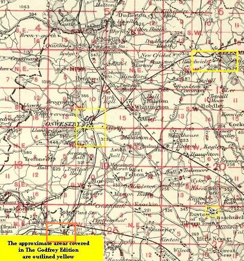
You might find this index map useful.
Follow this link for a complete list of our Shropshire Series maps. We have also published a small scale Inch to the Mile map for the area.
You can order maps direct from our On-line Mapshop. For other information and prices, and other areas, go to The Index Page.
Maps in the Godfrey Edition are taken from the 25 inch to the mile map and reduced to about 15 inches to the mile. For a full list of maps for the Shropshire area, return to the West Midlands page.
The Godfrey Edition / godfreyedition@btinternet.com / 23 December 2005