 Here are the details of maps for Gornal:

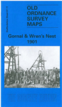
This detailed map covers the NW part of Dudley incl Shavers End and London Fields; coverage continues westward to Lower Gornal, northward to Upper Gornal. The map doubles as Worcestershire sheet 1.11.
Features on the map include Dudley Workhouse, tramways, football ground, Russell's Hall, Woodsellor's Farm, Wren's Nest Hill, Old Priory Farm, London Fields Works, Dibdalebank, Dibdale Works, Graveyard, Dibdale Colliery, Upper Gornal Colliery, Ruiton, brick works, old coal shafts etc. The map is less industrial than most others in the area. On the reverse we include directories of Upper and Lower Gornal.
The map links up with sheets 67.07 Sedgley SE to the north, 67.10 Gornalwood to the west, 67.12 Dudley Castle to the east, 67.15 Dudley West to the south.