
Old Ordnance Survey Maps of Sandwell & The Black Country
These detailed maps normally cover an area of about one and a half miles by one mile. Each map includes an introduction.
They are available through our On-line Mapshop
Sandwell Metropolitan Borough was formed in 1974 from Warley County Borough (which itself was formed from Smethwick County Borough, Oldbury Municipal Borough, and
Rowley Regis Municipal Borough) and West Bromwich County Borough (which had previously absorbed Tipton Municipal Borough and Wednesbury Municipal Borough). It included
former portions of Staffordshire and Worcestershire and became part of a new West Midlands county.
This page includes the maps which cover today's Sandwell MBC area.
Staffs 63.09a Willenhall & Darlaston Green 1885 publ 1990; intro by Cath Yates
Staffs 63.09b Willenhall & Darlaston Green 1901 publ 2009; intro by Malcolm Nixon
Staffs 63.09c Willenhall & Darlaston Green 1913 publ 2021; intro by Barrie Trinder
Staffs 63.13a Darlaston & King's Hill 1901 publ 1988; intro by John Maddison
Staffs 63.13b Darlaston 1913 publ 2018; intro by Barrie Trinder
Staffs 63.14a Bescot 1901 publ 1986; intro by John Maddison.
Staffs 63.14b Bescot 1913 publ 2017; intro by Barrie Trinder
Staffs 67.04a Bradley, Coseley & Wednesbury Oak 1901 publ 1993; intro by Robin Pearson
Staffs 67.04b Bradley, Coseley & Wednesbury Oak 1913 publ 2000; intro by Angus Dunphy
Staffs 67.08a Tipton 1884 publ 2018; intro by Angus Dunphy
Staffs 67.08b Tipton 1904 publ 1989; intro by Robin Pearson
Staffs 67.08c Tipton 1914 publ 2017; intro by Barrie Trinder
Staffs 67.12a Dudley Castle & Tipton Green 1901 publ 1989; intro by Robin Pearson
Staffs 67.12b Dudley Castle & Tipton Green 1913 publ 2017; intro by Barrie Trinder
Staffs 68.01a Wednesbury 1902 publ 1987; intro by John Maddison
Staffs 68.01b Wednesbury 1913 publ 2018; intro by Barrie Trinder
Staffs 68.02a Mesty Croft 1888 publ 1990; intro by John Maddison
Staffs 68.02b Wednesbury (Mesty Croft) 1902 publ 2009; intro by Malcolm Nixon
Staffs 68.02c Mesty Croft 1913 publ 2018; intro by Barrie Trinder
Staffs 68.03 Tame Bridge 1901 publ 2009; into by Malcolm Nixon
Staffs 68.05a Great Bridge & Toll End 1902 publ 1988; intro by Robin Pearson
Staffs 68.05b Great Bridge & Toll End 1913 publ 2018; intro by Barrie Trinder
Staffs 68.06a West Bromwich North 1885 publ 2013; intro by Malcolm Nixon  Staffs 68.06b West Bromwich North 1938 publ 2018; intro by Mike Jee
Staffs 68.09a Greets Green 1902 publ 1988; intro by Robin Pearson
Staffs 68.09b Greets Green 1913 publ 2018; intro by Barrie Trinder
Staffs 68.10a West Bromwich 1886 publ 2011; intro by Malcolm Nixon
Staffs 68.10b West Bromwich 1902 publ 1988; intro by John Maddison
Staffs 68.10c West Bromwich 1913 publ 2017; intro by Barrie Trinder
Staffs 68.10d West Bromwich 1938 publ 2018; intro by Mike Jee
Staffs 68.11 Sandwell Hall 1902 publ 1991; intro by John Stokes. Includes extract of 1916 edition
on reverse.
Staffs 68.12 Handsworth Wood 1902 publ 2002; intro by Alan Godfrey
Staffs 68.13a Brades Village 1902 publ 1991; intro by Mary Bodfish
Staffs 68.13b Brades Village 1913 publ 2018; intro by Barrie Trinder
Staffs 68.14a Oldbury & Spon Lane 1904 publ 1989; intro by Mary Bodfish
Staffs 68.14b Oldbury & Spon Lane 1913 publ 2017; intro by Barrie Trinder
Staffs 68.14c Oldbury & Spon Lane 1938 publ 2021; intro by Mike Jee
Staffs 68.15a The Hawthorns 1886 publ 1990; intro by Claire Harrington
Staffs 68.15b The Hawthorns 1913 publ 2011; intro by Michael Jee
Staffs 71.04 Netherton & Springfield 1901 publ 1995; intro by John Maddison
Staffs 71.08a Cradley Heath & Old Hill 1881 publ 2017; intro by Angus Dunphy
Staffs 71.08b Cradley Heath & Old Hill 1901 publ 1995; intro by Robin Pearson
Staffs 72.01a Whiteheath Gate 1902 publ 1989; intro by John Maddison
Staffs 72.01b Whiteheath Gate 1914 publ 2019; intro by Barrie Trinder
Staffs 72.02a Langley & Londonderry 1902 publ 1988; intro by John Maddison
Staffs 72.02b Langley Green & South Oldbury 1914 publ 2017; intro by Mike Jee
Staffs 72.02c Langley Green & South Oldbury 1938 publ 2018; intro by Barrie Trinder
Staffs 72.03a Smethwick 1901 publ 1987; intro by John Maddison
Staffs 72.03b Smethwick 1913 publ 2014; intro by Michael Jee
Staffs 72.03c Smethwick 1938 publ 2021; intro by Barrie Trinder
Staffs 72.05 Rowley Regis & Blackheath 1902 publ 1992; intro by John Maddison
Staffs 72.06 Warley 1902 publ 1996; intro by Steve Cemm. Includes an Inch to the Mile map of the
Black Country in 1872.
Staffs 72.07a Bearwood 1903 publ 1986; intro by John Maddison
Staffs 72.07b Bearwood 1913 publ 2019; intro by Barrie Trinder
Worcs. 05.10 Quinton 1902 publ 1993; intro by John Maddison
Staffs 68.06b West Bromwich North 1938 publ 2018; intro by Mike Jee
Staffs 68.09a Greets Green 1902 publ 1988; intro by Robin Pearson
Staffs 68.09b Greets Green 1913 publ 2018; intro by Barrie Trinder
Staffs 68.10a West Bromwich 1886 publ 2011; intro by Malcolm Nixon
Staffs 68.10b West Bromwich 1902 publ 1988; intro by John Maddison
Staffs 68.10c West Bromwich 1913 publ 2017; intro by Barrie Trinder
Staffs 68.10d West Bromwich 1938 publ 2018; intro by Mike Jee
Staffs 68.11 Sandwell Hall 1902 publ 1991; intro by John Stokes. Includes extract of 1916 edition
on reverse.
Staffs 68.12 Handsworth Wood 1902 publ 2002; intro by Alan Godfrey
Staffs 68.13a Brades Village 1902 publ 1991; intro by Mary Bodfish
Staffs 68.13b Brades Village 1913 publ 2018; intro by Barrie Trinder
Staffs 68.14a Oldbury & Spon Lane 1904 publ 1989; intro by Mary Bodfish
Staffs 68.14b Oldbury & Spon Lane 1913 publ 2017; intro by Barrie Trinder
Staffs 68.14c Oldbury & Spon Lane 1938 publ 2021; intro by Mike Jee
Staffs 68.15a The Hawthorns 1886 publ 1990; intro by Claire Harrington
Staffs 68.15b The Hawthorns 1913 publ 2011; intro by Michael Jee
Staffs 71.04 Netherton & Springfield 1901 publ 1995; intro by John Maddison
Staffs 71.08a Cradley Heath & Old Hill 1881 publ 2017; intro by Angus Dunphy
Staffs 71.08b Cradley Heath & Old Hill 1901 publ 1995; intro by Robin Pearson
Staffs 72.01a Whiteheath Gate 1902 publ 1989; intro by John Maddison
Staffs 72.01b Whiteheath Gate 1914 publ 2019; intro by Barrie Trinder
Staffs 72.02a Langley & Londonderry 1902 publ 1988; intro by John Maddison
Staffs 72.02b Langley Green & South Oldbury 1914 publ 2017; intro by Mike Jee
Staffs 72.02c Langley Green & South Oldbury 1938 publ 2018; intro by Barrie Trinder
Staffs 72.03a Smethwick 1901 publ 1987; intro by John Maddison
Staffs 72.03b Smethwick 1913 publ 2014; intro by Michael Jee
Staffs 72.03c Smethwick 1938 publ 2021; intro by Barrie Trinder
Staffs 72.05 Rowley Regis & Blackheath 1902 publ 1992; intro by John Maddison
Staffs 72.06 Warley 1902 publ 1996; intro by Steve Cemm. Includes an Inch to the Mile map of the
Black Country in 1872.
Staffs 72.07a Bearwood 1903 publ 1986; intro by John Maddison
Staffs 72.07b Bearwood 1913 publ 2019; intro by Barrie Trinder
Worcs. 05.10 Quinton 1902 publ 1993; intro by John Maddison
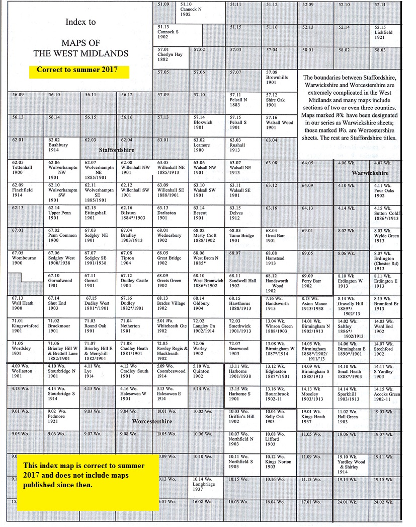
You might find this Index Map useful.
 Follow the following links for maps in Dudley, Walsall, Wolverhampton,
Birmingham or here for all the Birmingham and Black Country titles..
Most maps in the Godfrey Edition are taken from the 25 inch to the mile map and reduced to about 15 inches to the mile.
For a full list of English maps, return to the England page
You can order maps direct from our On-line Mapshop.
This list shows all the principal maps for the borough. We try to keep a full range in print but inevitably some titles fall out of print from time to time.
These are noted in our On-line Mapshop.
Follow the following links for maps in Dudley, Walsall, Wolverhampton,
Birmingham or here for all the Birmingham and Black Country titles..
Most maps in the Godfrey Edition are taken from the 25 inch to the mile map and reduced to about 15 inches to the mile.
For a full list of English maps, return to the England page
You can order maps direct from our On-line Mapshop.
This list shows all the principal maps for the borough. We try to keep a full range in print but inevitably some titles fall out of print from time to time.
These are noted in our On-line Mapshop.
Alan Godfrey Maps, Prospect Business Park, Leadgate, Consett, DH8 7PW. Tel 01207 583388
The Godfrey Edition / sales@alangodfreymaps.co.uk / 15 June 2021