
Old Ordnance Survey Maps of Wolverhampton
We have published a good range of maps for the City of Wolverhampton area:
Wolverhampton became a municipal borough in 1849 and a county borough in 1889. In 1933 it was expanded to include parts of Cannock and Seisdon rural districts, and in 1966 was expanded again, to
include most of the borough of Bilston, the urban districts of Tettenhall and Wednesfield, and part of Coseley UDC. It gained city status in 2000.
The following maps are taken from the OS 25" maps and reduced to a scale of approximately 15 inches to the mile. Most maps cover a mile
by a mile and a half each. Each map includes an introduction. They are available from our On-line Mapshop.
 These are the maps we have published for Wolverhampton:
62.02 Wolverhampton (Bushbury) 1914 - published 2005; intro by Angus Dunphy
62.05 Tettenhall 1900 - published 2005; intro by Angus Dunphy
62.06a Wolverhampton (NW) 1901 published 1994; introduction by John Boynton
62.06b Wolverhampton (NW) 1914 published 2019; introduction by Barrie Trinder
62.07a Wolverhampton (NE) 1885 publ 2017; intro by Barrie Trinder
62.07b Wolverhampton (NE) & Heath Town 1901 publ 1995; intro by John Boynton
62.07c Wolverhampton (NE) & Heath Town 1913 publ 2019; intro by Mike Jee
62.08a Willenhall (NW) & Wednesfield 1901 publ 1997; intro by Horace Davis
62.08b Willenhall (NW) & Wednesfield 1913 publ 2021; intro by Barrie Trinder
62.09 Finchfield & Wightwick 1914 publ 2005; intro by Angus Dunphy
62.10a Wolverhampton (SW) 1901 publ 1995, rev 2004; intro by John Boynton
62.10b Wolverhampton (SW) 1914 publ 2021; intro by Barrie Trinder
62.11a Wolverhampton (SE) 1885 publ 2017; intro by Barrie Trinder
62.11b Wolverhampton (SE) 1901 publ 1996; intro by Elizabeth Rees
62.11c Wolverhampton (SE) 1913 publ 2021; intro by Barrie Trinder
62.12a Willenhall SW 1901 publ 1996; intro by Horace Davis
62.12b Willenhall SW 1913 publ 2021; intro by Barrie Trinder
62.14 Upper Penn 1901 publ 1996; intro by Angus Dunphy
62.15a Ettingshall 1901 publ 1996; intro by John Boynton
62.15b Ettingshall 1913 publ 2021; intro by Barrie Trinder
62.16a Bilston 1884 publ 2011; intro by Barrie Trinder  62.16b Bilston 1901 publ 1992; intro by Elizabeth Rees
62.16c Bilston 1913 publ 2021; intro by Barrie Trinder
67.02 Penn Common 1900 publ 1997; intro by Angus Dunphy
67.03 Sedgley (NE) & Deepfields 1901 publ 1993; intro by Angus Dunphy
67.04a Bradley, Coseley & Wednesbury Oak 1901 publ 1993; intro by Robin Pearson
67.04b Bradley, Coseley & Wednesbury Oak 1913 publ 2000; intro by Angus Dunphy
67.05 Wombourne 1900 publ 2000; intro by Angus Dunphy
67.06a Sedgley (West) 1900 publ 1997; intro by Angus Dunphy
67.06b Sedgley (West) 1938 publ 2014; intro by Malcolm Nixon
67.07a Sedgley (SE) & West Coseley 1901 publ 1997; intro by Angus Dunphy
67.07b Sedgley (SE) & West Coseley 1938 publ 2015; intro by Malcolm Nixon
62.16b Bilston 1901 publ 1992; intro by Elizabeth Rees
62.16c Bilston 1913 publ 2021; intro by Barrie Trinder
67.02 Penn Common 1900 publ 1997; intro by Angus Dunphy
67.03 Sedgley (NE) & Deepfields 1901 publ 1993; intro by Angus Dunphy
67.04a Bradley, Coseley & Wednesbury Oak 1901 publ 1993; intro by Robin Pearson
67.04b Bradley, Coseley & Wednesbury Oak 1913 publ 2000; intro by Angus Dunphy
67.05 Wombourne 1900 publ 2000; intro by Angus Dunphy
67.06a Sedgley (West) 1900 publ 1997; intro by Angus Dunphy
67.06b Sedgley (West) 1938 publ 2014; intro by Malcolm Nixon
67.07a Sedgley (SE) & West Coseley 1901 publ 1997; intro by Angus Dunphy
67.07b Sedgley (SE) & West Coseley 1938 publ 2015; intro by Malcolm Nixon
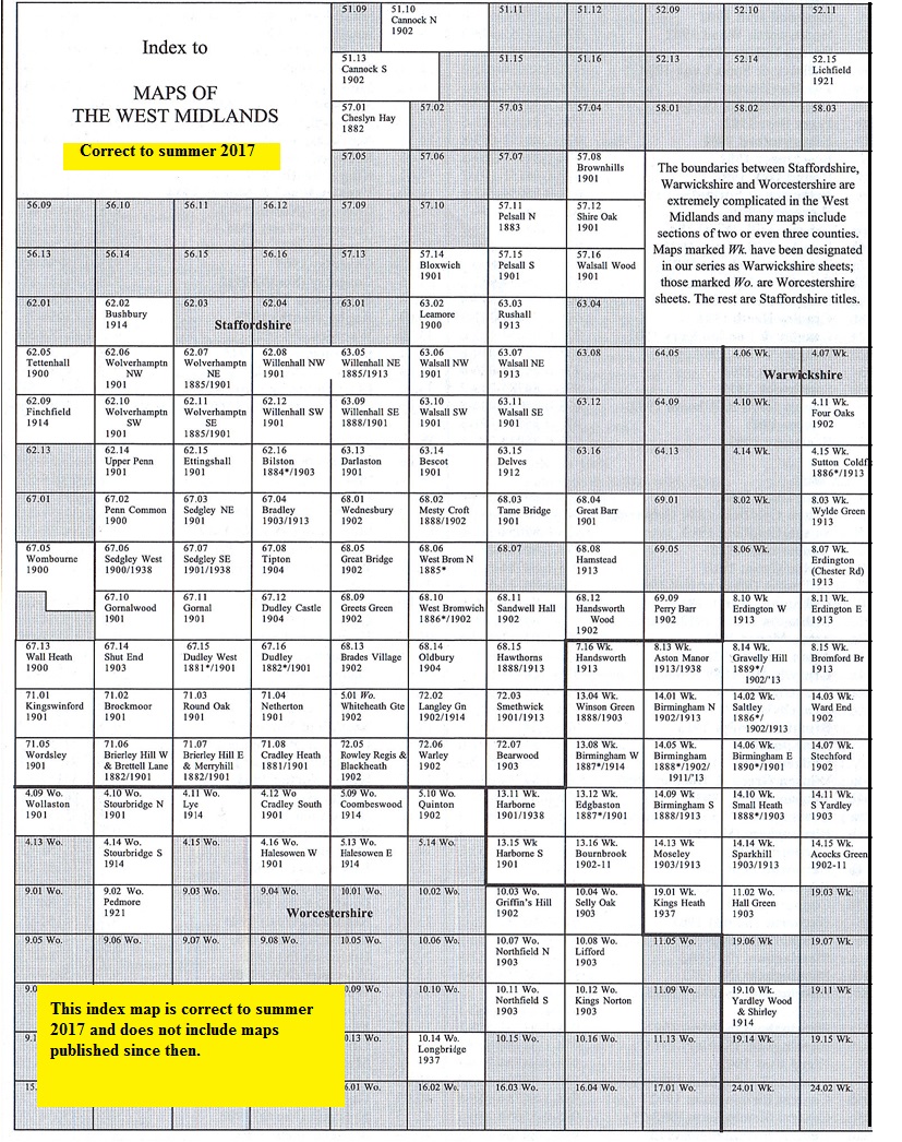
You might find this Index Map useful.
We also publish many smaller scale "Inch to the Mile" maps. For details and index maps
visit the One Inch page. The following map covers much of the Wolverhampton area:
153 Wolverhampton & Ironbridge 1898 publ 2001; intro by Barrie Trinder. Covers area from Wolverhampton to
Ironbridge, Shifnal and Penkridge.
 Follow the following links for maps in Dudley, Walsall, Sandwell,
Birmingham or here for all the Birmingham and Black Country titles..
Most maps in the Godfrey Edition are taken from the 25 inch to the mile map and reduced to about 15 inches to the mile.
For a full list of English maps, return to the England page
You can order maps direct from our On-line Mapshop.
This list shows all the principal maps for the borough. We try to keep a full range in print but inevitably some titles fall out of print from time to time.
These are noted in our On-line Mapshop.
Follow the following links for maps in Dudley, Walsall, Sandwell,
Birmingham or here for all the Birmingham and Black Country titles..
Most maps in the Godfrey Edition are taken from the 25 inch to the mile map and reduced to about 15 inches to the mile.
For a full list of English maps, return to the England page
You can order maps direct from our On-line Mapshop.
This list shows all the principal maps for the borough. We try to keep a full range in print but inevitably some titles fall out of print from time to time.
These are noted in our On-line Mapshop.
Alan Godfrey Maps, Prospect Business Park, Leadgate, Consett, DH8 7PW. Tel 01207 583388
The Godfrey Edition / sales@alangodfreymaps.co.uk / 11 October 2021