
 Here are the details of maps for Worcester (NW):

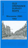
This detailed map covers the NW quarter of Worcester, with coverage stretching from The Tything westward to Dines Green, and from tne Infirmary northward to Lavender Road.
Features include Pitchcroft, Race Course, Water Works, Leather Works, Barbourne College, brewery, Britannia Square, Infirmary, Shewring's Hospital, Royal Free Grammar School, St George's church, Baskerville House, Henwick Grove, Henwick Mill, Lower Temple Laughern, Ambrose Farm, Henwick Hall, Henwick Grange, Henwick House, Thorneloe Villa, etc. On the reverse we include a selection of street directory entries, incl Barbourne Road, Henwick Road, Hylton Road, The Moors, The Tything.
The map links up with sheets 33.04 Worcester NE to the east and 33.07 Worcester SW to the south.