
Old Ordnance Survey Maps of Manchester
This is our coverage of the City of Manchester. Manchester, historically in Lancashire, was incorporated as a Borough in 1838, granted the status of a City in 1853, and became a County Borough in 1889.
It had always been a very large parish and boundary extensions gradually brought much of this area into the city, including Bradford, Harpurhey and Rusholme in 1885, Newton Heath and Openshaw in 1890,
Chorlton cum Hardy and Didsbury in 1904, and Gorton in 1909. In 1931 the Baguley and Northenden areas of Cheshire were added. In 1974 it was reincorporated as a Metropolitan Borough, at the centre of the new Metropolitan County of Greater Manchester.
All maps are available from our On-line Mapshop.
The following titles are taken from the OS 25" maps and reduced to a scale of approximately 14 inches to the mile. Each covers an area of a mile and a half by one mile, and includes an introduction.
These are the maps for Manchester in our Lancashire series:
96.09a Prestwich 1915 - published 2004; intro by Chris Makepeace
96.09b Prestwich 1932 - published 2024; intro by Alan Godfrey
96.10 Heaton Park 1907 - published 1997; intro by Paul Hindle
96.11 Higher Blackley 1906 - published 2008; intro by Chris Makepeace
96.13 Rainsough, Kersal & Hilton Park 1907- published 2004; intro by Chris Makepeace
96.14 Broughton Park & Crumpsall 1907 - published 2003; intro by Chris Makepeace
96.15 Blackley & Lower Crumpsall 1915 - published 2007; intro by Chris Makepeace
96.16 Moston 1933 - published 2007; intro by Chris Makepeace
97.13 Failsworth & Hollinwood 1932 - published 2007; intro by Chris Makepeace
104.01a Pendleton North 1889 - published 1999; intro by Paul Hindle
104.01b Pendleton North 1915 - published 2015; intro by Chris Makepeace
104.01c Pendleton North 1931 - published 2015; intro by Alan Godfrey
104.02a Cheetham & Higher Broughton 1889 - published 2016; intro by Chris Makepeace
104.02b Cheetham & Higher Broughton 1915 - published 2016; intro by Alan Godfrey
104.02c Cheetham & Higher Broughton 1931 - published 2003; intro by Chris Makepeace
104.03a Manchester (Harpurhey & Collyhurst) 1893 - published 1997; intro by Chris Makepeace
104.03b Manchester (Harpurhey & Collyhurst) 1921 - published 2016; intro by Chris Makepeace
104.03c Manchester (Harpurhey & Collyhurst) 1931 - published 2016; intro by Alan Godfrey
104.04a Newton Heath 1889 - published 2012; intro by Chris Makepeace  104.04b Newton Heath 1915 - published 2005; intro by Chris Makepeace
104.04c Newton Heath 1931 - published 2016; intro by Alan Godfrey
104.05a Salford West 1889 - published 2012; intro by Chris Makepeace
104.05b Salford West 1916 - published 2001; intro by Chris Makepeace
104.05c Salford West 1931 - published 2015; intro by Alan Godfrey
104.06a Manchester NW & Central Salford 1915 - published 2001; intro by Chris Makepeace.
104.06b Manchester NW & Central Salford 1931 - published 2015; intro by Alan Godfrey
104.07a Manchester NE 1891 - published 1998; intro by Chris Makepeace
104.07b Manchester NE 1915 - published 2012; intro by Chris Makepeace
104.07c Manchester NE 1931 - published 2014; intro by Chris Makepeace
104.08a Manchester (Clayton) 1915 - published 2016; intro by Chris Makepeace
104.08b Manchester (Clayton) 1932 - published 2003; intro by Chris Makepeace
104.09a Salford Docks 1905 - published 1985; intro by Chris Makepeace
104.09b Salford Docks 1916 - published 2015; intro by Chris Makepeace
104.09c Salford Docks 1932 - published 2015; intro by Alan Godfrey
104.10a Manchester SW 1894 - published 1995; intro by Chris Makepeace
104.10b Manchester SW 1916 - published 2011; intro by Chris Makepeace
104.10c Manchester SW 1932 - published 2016; intro by Alan Godfrey
104.11a Manchester SE 1915 - published 1991; intro by Chris Makepeace
104.11b Manchester SE & Ardwick 1932 - published 2015; intro by Alan Godfrey
104.12a Openshaw 1905 - published 1987; intro by Chris Makepeace
104.12b Openshaw 1916 - published 2015; intro by Chris Makepeace
104.12c Openshaw 1933 - published 2016; intro by Alan Godfrey
104.13a Old Trafford 1905 - published 1985; intro by Chris Makepeace
104.13b Old Trafford 1915 - published 2015; intro by Chris Makepeace
104.13c Old Trafford 1931 - published 2015; intro by Alan Godfrey
104.14a Moss Side 1889 - published 1996; intro by Chris Makepeace
104.14b Moss Side 1915 - published 2011; intro by Chris Makepeace
104.14c Moss Side 1932 - published 2017; intro by Alan Godfrey
104.15a Victoria Park 1893 - published 1988; intro by Chris Makepeace
104.15b Manchester (Victoria Park & Longsight) 1916 - published 2011; intro by Chris Makepeace
104.16a Gorton & Belle Vue 1890 - published 2018; intro by Alan Godfrey
104.16b Gorton & Belle Vue 1905 - published 1996; intro by Chris Makepeace
104.16c Gorton & Belle Vue 1916 - published 2015; intro by Chris Makepeace
104.16d Gorton & Belle Vue 1933 - published 2015; intro by Alan Godfrey
105.01 Failsworth South & Woodhouses 1931 - published 2007; intro by Chris Makepeace
105.05 Droylsden & Medlock Vale 1906 - published 1993; intro by Gillian Coke
105.09a Audenshaw & Droylsden 1916 publ 1992; intro by Chris Makepeace
105.09b Audenshaw & Droylsden 1933 publ 2016; intro by Alan Godfrey
105.10 Guide Bridge 1918 - published 1992; intro by Chris Makepeace
105.13a Denton West & Gorton Bridge 1891 - published 2018; intro by Chris Makepeace
105.13b Denton West 1916 - published 1996; intro by Jill Cronin
105.13c Denton West & Gorton Bridge 1934 - published 2017; intro by Alan Godfrey
105.14a Denton Town Centre 1918 - published 1996; intro by Jill Cronin
105.14b Denton 1934 - published 2017; intro by Alan Godfrey
111.01a Chorlton cum Hardy & Stretford 1905 - published 1994; intro by Nick Burton
111.01b Chorlton cum Hardy & Stretford 1915 - published 2015; intro by Chris Makepeace
111.01b Chorlton cum Hardy & Stretford 1933 - published 2016; intro by Alan Godfrey
111.02a Whalley Range 1892 - published 2020; intro by Chris Makepeace
111.02b Whalley Range 1905 - published 1994; intro by Chris Makepeace
111.02c Whalley Range 1916 - published 2018; intro by Chris Makepeace
111.02d Whalley Range 1933 - published 2019; intro by Alan Godfrey
111.03a Fallowfield 1905 - published 1994; intro by Chris Makepeace
111.03b Fallowfield & South Rusholme 1916 - published 2019; intro by Chris Makepeace
111.03c Fallowfield & South Rusholme 1933 - published 2019; intro by Alan Godfrey
111.04a Levenshulme 1905 - published 1998, minor rev 2019; intro by Chris Makepeace
111.04b Levenshulme 1916 - published 2019; intro by Chris Makepeace
111.04c Levenshulme 1933 - published 2019; intro by Alan Godfrey
111.05 Chorlton cum Hardy (South) 1905 - published 1998; intro by Chris Makepeace
111.06 Barlow Moor 1905 - published 1993; intro by Chris Makepeace
111.07a Withington 1892 - published 2012; intro by Chris Makepeace
111.07b Withington & Burnage 1916 - published 1996; intro by Chris Makepeace
111.07c Withington & Burnage 1934 - published 2019; intro by Chris Makepeace
111.08a Heaton Chapel 1904 - published 1998; intro by Chris Makepeace
111.08b Heaton Chapel 1916 - published 2019; intro by Chris Makepeace
111.08c Heaton Chapel 1934 - published 2019; intro by Alan Godfrey
111.10a Didsbury (Palatine Rd) 1904 - published 1992; intro by Chris Makepeace
111.10b Didsbury (Palatine Rd) 1916 - published 2017; intro by Chris Makepeace
111.11a Didsbury (Heaton Mersey) 1904 - published 1992; intro by Chris Makepeace
111.11b Didsbury (Heaton Mersey) 1916 - published 2017; intro by Chris Makepeace
111.12a Heaton Norris 1893 - published 2013; intro by Chris Makepeace
111.12b Stockport (Heaton Norris) 1916 - published 1998; intro by Chris Makepeace
111.12c Heaton Norris & Heaton Moor 1934 - published 2018; intro by Alan Godfrey
111.13a Baguley 1916 - published 2020; intro by Chris Makepeace
111.13b Baguley 1935 - published 2020; intro by Chris Makepeace
111.14a Northenden 1916 - published 2020; intro by Chris Makepeace
111.14b Northenden 1934 - published 2020; intro by Chris Makepeace
111.15 Cheadle North 1916 - published 1996; intro by Chris Makepeace
104.04b Newton Heath 1915 - published 2005; intro by Chris Makepeace
104.04c Newton Heath 1931 - published 2016; intro by Alan Godfrey
104.05a Salford West 1889 - published 2012; intro by Chris Makepeace
104.05b Salford West 1916 - published 2001; intro by Chris Makepeace
104.05c Salford West 1931 - published 2015; intro by Alan Godfrey
104.06a Manchester NW & Central Salford 1915 - published 2001; intro by Chris Makepeace.
104.06b Manchester NW & Central Salford 1931 - published 2015; intro by Alan Godfrey
104.07a Manchester NE 1891 - published 1998; intro by Chris Makepeace
104.07b Manchester NE 1915 - published 2012; intro by Chris Makepeace
104.07c Manchester NE 1931 - published 2014; intro by Chris Makepeace
104.08a Manchester (Clayton) 1915 - published 2016; intro by Chris Makepeace
104.08b Manchester (Clayton) 1932 - published 2003; intro by Chris Makepeace
104.09a Salford Docks 1905 - published 1985; intro by Chris Makepeace
104.09b Salford Docks 1916 - published 2015; intro by Chris Makepeace
104.09c Salford Docks 1932 - published 2015; intro by Alan Godfrey
104.10a Manchester SW 1894 - published 1995; intro by Chris Makepeace
104.10b Manchester SW 1916 - published 2011; intro by Chris Makepeace
104.10c Manchester SW 1932 - published 2016; intro by Alan Godfrey
104.11a Manchester SE 1915 - published 1991; intro by Chris Makepeace
104.11b Manchester SE & Ardwick 1932 - published 2015; intro by Alan Godfrey
104.12a Openshaw 1905 - published 1987; intro by Chris Makepeace
104.12b Openshaw 1916 - published 2015; intro by Chris Makepeace
104.12c Openshaw 1933 - published 2016; intro by Alan Godfrey
104.13a Old Trafford 1905 - published 1985; intro by Chris Makepeace
104.13b Old Trafford 1915 - published 2015; intro by Chris Makepeace
104.13c Old Trafford 1931 - published 2015; intro by Alan Godfrey
104.14a Moss Side 1889 - published 1996; intro by Chris Makepeace
104.14b Moss Side 1915 - published 2011; intro by Chris Makepeace
104.14c Moss Side 1932 - published 2017; intro by Alan Godfrey
104.15a Victoria Park 1893 - published 1988; intro by Chris Makepeace
104.15b Manchester (Victoria Park & Longsight) 1916 - published 2011; intro by Chris Makepeace
104.16a Gorton & Belle Vue 1890 - published 2018; intro by Alan Godfrey
104.16b Gorton & Belle Vue 1905 - published 1996; intro by Chris Makepeace
104.16c Gorton & Belle Vue 1916 - published 2015; intro by Chris Makepeace
104.16d Gorton & Belle Vue 1933 - published 2015; intro by Alan Godfrey
105.01 Failsworth South & Woodhouses 1931 - published 2007; intro by Chris Makepeace
105.05 Droylsden & Medlock Vale 1906 - published 1993; intro by Gillian Coke
105.09a Audenshaw & Droylsden 1916 publ 1992; intro by Chris Makepeace
105.09b Audenshaw & Droylsden 1933 publ 2016; intro by Alan Godfrey
105.10 Guide Bridge 1918 - published 1992; intro by Chris Makepeace
105.13a Denton West & Gorton Bridge 1891 - published 2018; intro by Chris Makepeace
105.13b Denton West 1916 - published 1996; intro by Jill Cronin
105.13c Denton West & Gorton Bridge 1934 - published 2017; intro by Alan Godfrey
105.14a Denton Town Centre 1918 - published 1996; intro by Jill Cronin
105.14b Denton 1934 - published 2017; intro by Alan Godfrey
111.01a Chorlton cum Hardy & Stretford 1905 - published 1994; intro by Nick Burton
111.01b Chorlton cum Hardy & Stretford 1915 - published 2015; intro by Chris Makepeace
111.01b Chorlton cum Hardy & Stretford 1933 - published 2016; intro by Alan Godfrey
111.02a Whalley Range 1892 - published 2020; intro by Chris Makepeace
111.02b Whalley Range 1905 - published 1994; intro by Chris Makepeace
111.02c Whalley Range 1916 - published 2018; intro by Chris Makepeace
111.02d Whalley Range 1933 - published 2019; intro by Alan Godfrey
111.03a Fallowfield 1905 - published 1994; intro by Chris Makepeace
111.03b Fallowfield & South Rusholme 1916 - published 2019; intro by Chris Makepeace
111.03c Fallowfield & South Rusholme 1933 - published 2019; intro by Alan Godfrey
111.04a Levenshulme 1905 - published 1998, minor rev 2019; intro by Chris Makepeace
111.04b Levenshulme 1916 - published 2019; intro by Chris Makepeace
111.04c Levenshulme 1933 - published 2019; intro by Alan Godfrey
111.05 Chorlton cum Hardy (South) 1905 - published 1998; intro by Chris Makepeace
111.06 Barlow Moor 1905 - published 1993; intro by Chris Makepeace
111.07a Withington 1892 - published 2012; intro by Chris Makepeace
111.07b Withington & Burnage 1916 - published 1996; intro by Chris Makepeace
111.07c Withington & Burnage 1934 - published 2019; intro by Chris Makepeace
111.08a Heaton Chapel 1904 - published 1998; intro by Chris Makepeace
111.08b Heaton Chapel 1916 - published 2019; intro by Chris Makepeace
111.08c Heaton Chapel 1934 - published 2019; intro by Alan Godfrey
111.10a Didsbury (Palatine Rd) 1904 - published 1992; intro by Chris Makepeace
111.10b Didsbury (Palatine Rd) 1916 - published 2017; intro by Chris Makepeace
111.11a Didsbury (Heaton Mersey) 1904 - published 1992; intro by Chris Makepeace
111.11b Didsbury (Heaton Mersey) 1916 - published 2017; intro by Chris Makepeace
111.12a Heaton Norris 1893 - published 2013; intro by Chris Makepeace
111.12b Stockport (Heaton Norris) 1916 - published 1998; intro by Chris Makepeace
111.12c Heaton Norris & Heaton Moor 1934 - published 2018; intro by Alan Godfrey
111.13a Baguley 1916 - published 2020; intro by Chris Makepeace
111.13b Baguley 1935 - published 2020; intro by Chris Makepeace
111.14a Northenden 1916 - published 2020; intro by Chris Makepeace
111.14b Northenden 1934 - published 2020; intro by Chris Makepeace
111.15 Cheadle North 1916 - published 1996; intro by Chris Makepeace
The following Cheshire map also covers part of this area:
10.14 Heaton Mersey 1907 - published 2013; intro by Chris Makepeace
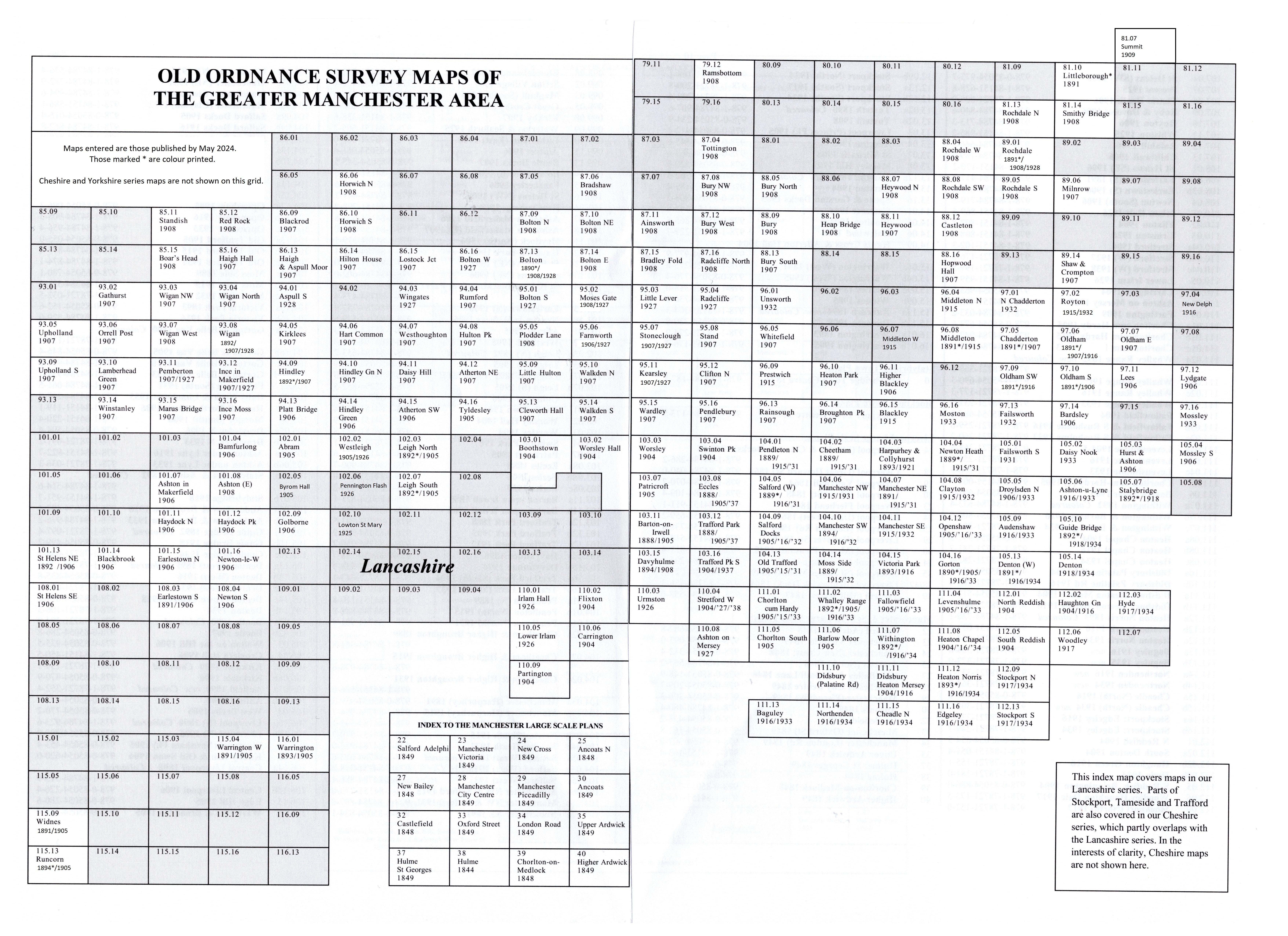
Here is an Index Map to our Manchester maps.
We have also published 17 very Large Scale Plans, taken from the very early 5 foot plans in the 1840s. See separate page for details.
We also publish a series of smaller scale Inch to the Mile maps. Much of the area is covered by the following map:
85 Manchester & District 1896 - published 1999; intro by Chris Makepeace
For full details of this series visit the One Inch page.
 Most maps in the Godfrey Edition are taken from the 25 inch to the mile map and reduced to about 15 inches to the mile.
For a full list of English maps, return to the England page.
You can order maps direct from our On-line Mapshop.
Most maps in the Godfrey Edition are taken from the 25 inch to the mile map and reduced to about 15 inches to the mile.
For a full list of English maps, return to the England page.
You can order maps direct from our On-line Mapshop.
Alan Godfrey Maps, Prospect Business Park, Leadgate, Consett, DH8 7PW. Tel 01207 583388
The Godfrey Edition / sales@alangodfreymaps.co.uk / 16 October 2024