
Old Ordnance Survey Maps of Salford
This is our coverage of the City of Salford. Salford became a county borough in 1889 and was granted city status in 1926. The present
County Borough of the City of Salford was created in 1974 with the amalgamation of Salford with the Borough of Eccles, the Borough of Swinton & Pendlebury,
Irlam Urban District and Worsley Urban District. At the same time it became one of the ten metropolitan boroughs in the new county of Greater Manchester. It is
now a unitary authority.
All maps are available from our On-line Mapshop.
The following titles are taken from the OS 25" maps and reduced to a scale of approximately 14 inches to the mile.
They are extremely detailed, showing individual houses, details such as railway tracks, pathways,
pubs, factories and even minutiae such as fountains and signal posts. Each covers an area of a mile and a half by one mile, and includes an introduction.
These are our maps for Salford in our Lancashire series:
095.09 Little Hulton 1907 - published 2007; intro by Alan Godfrey
095.10 Walkden North & Blackleach 1907 - published 2003; intro by Alan Godfrey
095.12 Clifton (North) & Wet Earth Colliery 1907 - published 2008; intro by Alan Godfrey
095.13 Cleworth Hall 1907 - published 2007; intro by Alan Godfrey
095.14 Walkden South 1907 - published 2003; intro by Alan Godfrey
095.15 Wardley 1907 - published 1999; intro by Paul Hindle
095.16 Pendlebury 1907 - published 1997; intro by Chris Makepeace
096.13 Rainsough, Kersal & Hilton Park 1907- published 2004; intro by Chris Makepeace
103.01 Boothstown & Astley Green 1904 - publ 2005; intro by Alan Godfrey
103.02 Worsley Hall 1904 - published 2004; intro by Alan Godfrey
103.03 Worsley 1904 - published 2003; intro by Alan Godfrey
103.04 Swinton Park & Irlan o'th'Heights 1907 - published 1997; intro by Chris Makepeace
103.07 Patricroft & Monton 1905 - published 2006; intro by Chris Makepeace
103.08a Eccles 1888 - published 2015; intro by Chris Makepeace
103.08b Eccles 1905 - published 2003; intro by Chris Makepeace
103.08c Eccles 1937 - published 2015; intro by Alan Godfrey
103.11 Barton upon Irwell 1888 - published 1996; intro by Nick Burton. On the reverse is a
six-inch scale map of Eccles, Barton and Patricroft in 1845.
103.12 Trafford Park 1905 - published 1997; intro by Nick Burton.
103.15a Davyhulme 1898 - published 1996; intro by Chris Makepeace.
103.15b Davyhulme 1904 - published 2015; intro by Chris Makepeace.
104.01a Pendleton North 1889 - published 1999; intro by Paul Hindle
104.01b Pendleton North 1915 - published 2015; intro by Chris Makepeace
104.01c Pendleton North 1931 - published 2015; intro by Alan Godfrey
104.02a Cheetham & Higher Broughton 1889 - published 2016; intro by Chris Makepeace
104.02b Cheetham & Higher Broughton 1915 - published 2016; intro by Alan Godfrey
104.02c Cheetham & Higher Broughton 1931 - published 2003; intro by Chris Makepeace
104.05a Salford West 1889 - published 2012; intro by Chris Makepeace  104.05b Salford West 1916 - published 2001; intro by Chris Makepeace
104.05c Salford West 1931 - published 2015; intro by Alan Godfrey
104.06a Manchester NW & Central Salford 1915 - published 2001; intro by Chris Makepeace
104.06b Manchester NW & Central Salford 1931 - published 2015; intro by Alan Godfrey
104.09a Salford Docks 1905 - published 1985; intro by Chris Makepeace
104.09b Salford Docks 1916 - published 2015; intro by Chris Makepeace
104.09c Salford Docks & Ordsall 1932 - published 2015; intro by Alan Godfrey
104.10a Manchester SW 1894 - published 1995; intro by Chris Makepeace
104.10b Manchester SW 1916 - published 2011; intro by Chris Makepeace
104.10c Manchester SW 1932 - published 2016; intro by Alan Godfrey
104.13a Old Trafford 1905 - published 1985; intro by Chris Makepeace
104.13b Old Trafford 1915 - published 2015; intro by Chris Makepeace
104.13c Old Trafford 1931 - published 2015; intro by Alan Godfrey
110.01 Irlam Hall 1926 - published 2005; intro by Chris Makepeace
110.02 Flixton 1904 - published 2005; intro by Chris Makepeace
110.03 Urmston 1926 - published 2005; intro by Chris Makepeace
110.05 Lower Irlam & Cadishead 1926 - published 2006; intro by Chris Makepeace
110.09 Partington 1904 - published 2007; intro by Chris Makepeace
104.05b Salford West 1916 - published 2001; intro by Chris Makepeace
104.05c Salford West 1931 - published 2015; intro by Alan Godfrey
104.06a Manchester NW & Central Salford 1915 - published 2001; intro by Chris Makepeace
104.06b Manchester NW & Central Salford 1931 - published 2015; intro by Alan Godfrey
104.09a Salford Docks 1905 - published 1985; intro by Chris Makepeace
104.09b Salford Docks 1916 - published 2015; intro by Chris Makepeace
104.09c Salford Docks & Ordsall 1932 - published 2015; intro by Alan Godfrey
104.10a Manchester SW 1894 - published 1995; intro by Chris Makepeace
104.10b Manchester SW 1916 - published 2011; intro by Chris Makepeace
104.10c Manchester SW 1932 - published 2016; intro by Alan Godfrey
104.13a Old Trafford 1905 - published 1985; intro by Chris Makepeace
104.13b Old Trafford 1915 - published 2015; intro by Chris Makepeace
104.13c Old Trafford 1931 - published 2015; intro by Alan Godfrey
110.01 Irlam Hall 1926 - published 2005; intro by Chris Makepeace
110.02 Flixton 1904 - published 2005; intro by Chris Makepeace
110.03 Urmston 1926 - published 2005; intro by Chris Makepeace
110.05 Lower Irlam & Cadishead 1926 - published 2006; intro by Chris Makepeace
110.09 Partington 1904 - published 2007; intro by Chris Makepeace
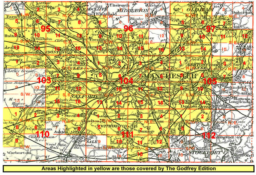
 Click on the thumbnail right for an index map for the Manchester area maps in our
Lancashire series.
Click on the thumbnail right for an index map for the Manchester area maps in our
Lancashire series.
The following large scale map, taken from the Five feet to the Mile Series, will also be of interest:
22 Salford Adelphi 1848 - published 1994; intro by Nick Burton
See the Manchester 5 Foot Page for further details of this series.
We also publish a series of smaller scale Inch to the Mile maps. This is the principal map for the area:
85 Manchester & District 1896 - published 1999; intro by Chris Makepeace
For details of this series visit the One Inch page.
 Most maps in the Godfrey Edition are taken from the 25 inch to the mile map and reduced to about 15 inches to the mile.
For a full list of English maps, return to the England page
You can order maps direct from our On-line Mapshop.
Most maps in the Godfrey Edition are taken from the 25 inch to the mile map and reduced to about 15 inches to the mile.
For a full list of English maps, return to the England page
You can order maps direct from our On-line Mapshop.
Alan Godfrey Maps, Prospect Business Park, Leadgate, Consett, DH8 7PW. Tel 01207 583388
The Godfrey Edition / sales@alangodfreymaps.co.uk / 4 April 2018
 Click on the thumbnail right for an index map for the Manchester area maps in our
Lancashire series.
Click on the thumbnail right for an index map for the Manchester area maps in our
Lancashire series.