
Old Ordnance Survey Maps of The Potteries and Newcastle
These detailed maps normally cover an area of about one and a half miles by one mile. Each map includes an introduction.
They are available through our On-line Mapshop.
These are the maps in today's Staffordshire County. They are taken from the OS 25" maps and reduced to a scale of approximately
15 inches to the mile. They are extremely detailed, showing individual houses, details such as railway tracks, pathways,
pubs, factories and even minutiae such as fountains and signal posts. Each covers an area a mile by a mile and a half and includes an introduction.
 These are the maps we publish for the Potteries & Newcastle:
06.15 Kidsgrove (West) 1897 - published 2013; intro by Derrick Pratt
06.16 Kidsgrove 1898 - published 2012; intro by Derrick Pratt
11.04 Tunstall (N) & Goldenhill 1898 - published 2011; intro by Malcolm Nixon
11.06 Audley 1898 - published 2016; intro by Malcolm Nixon
11.08a Tunstall 1877 - published 2012; intro by Derrick Pratt
11.08b Tunstall 1898 - published 1995; intro by Alan Godfrey
11.10 Halmer End & Alsagers Bank 1922 - published 2023; intro by Barrie Trinder
11.11 Chesterton 1922 - published 2023; intro by Barrie Trinder
11.12a Longport & Porthill 1898 - published 2004; intro by Malcolm Nixon
11.12b Longport & Porthill 1922 - published 2023; intro by Barrie Trinder
11.14 Scot Hay & Alsager Bank 1922 - published 2023; intro by Barrie Trinder
11.15 Knutton & Apedale Iron Works 1922 - published 2023; intro by Barrie Trinder
11.16 Wolstanton 1898 - published 2007; intro by Malcolm Nixon
12.01 Great Chell 1876 - published 2011; intro by Malcolm Nixon
12.05a Smallthorne & East Tunstall 1898 - publ 2012; intro by Derrick Pratt
12.05b Smallthorne & East Tunstall 1922 - publ 1996; intro by Alan Godfrey
12.06 Milton (North) 1898 - published 2008; intro by Malcolm Nixon
12.09a Burslem 1877 - publ 2011; intro by Derrick Pratt  12.09b Burslem 1898 - publ 1994; intro by Alan Godfrey
12.09c Burslem & Cobridge 1922 - publ 2022; intro by Barrie Trinder
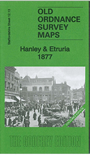
12.13a Hanley & Etruria 1877 - publ 2011; intro by Derrick Pratt
12.13b Hanley & Etruria 1898 - publ 1993; intro by Alan Godfrey
12.13c Hanley & Etruria 1923 - publ 2022; intro by Barrie Trinder
12.14 Hanley East & Bucknall 1898 - publ 2003; intro by Malcolm Nixon
17.02 Keele (North) 1898 - publ 2023; intro by Barrie Trinder
17.03 Silverdale 1898 - publ 2003; intro by Malcolm Nixon
17.04a Newcastle under Lyme 1877 - publ 2011; intro by Derrick Pratt
17.04b Newcastle under Lyme 1898 - publ 1989; intro by Dave Adams
17.04c Newcastle under Lyme 1922 - publ 2023; intro by Barrie Trinder
18.01a Stoke, Shelton & Hartshill 1898 - publ 1993, rev 2015; intro by Alan Godfrey
18.01b Stoke on Trent 1923 - publ 2022; intro by Barrie Trinder
18.02 Hanley SE (Joiner's Sq & Berry Hill) 1898 - publ 2018; intro by Malcolm Nixon
18.05a Stoke upon Trent (South) 1898 - publ 1993; intro by Alan Godfrey
18.05b Stoke upon Trent (South) 1923 - publ 2022; intro by Barrie Trinder
18.06a Fenton 1922 - publ 2004; intro by Malcolm Nixon
18.06b Fenton 1937 - publ 2024; intro by Barrie Trinder
18.07 Longton (Adderley Green) 1898 - published 2018; intro by Malcolm Nixon
18.09 Trent Vale & Hanford 1898 - published 2009; intro by Malcolm Nixon
18.10 Longton (West) 1898 - publ 1999; intro by Alan Godfrey
18.11 Longton (East) 1922 - publ 2004; intro by Malcolm Nixon
18.13 Trentham 1924 - published 2009; intro by Malcolm Nixon
12.09b Burslem 1898 - publ 1994; intro by Alan Godfrey
12.09c Burslem & Cobridge 1922 - publ 2022; intro by Barrie Trinder
12.13a Hanley & Etruria 1877 - publ 2011; intro by Derrick Pratt
12.13b Hanley & Etruria 1898 - publ 1993; intro by Alan Godfrey
12.13c Hanley & Etruria 1923 - publ 2022; intro by Barrie Trinder
12.14 Hanley East & Bucknall 1898 - publ 2003; intro by Malcolm Nixon
17.02 Keele (North) 1898 - publ 2023; intro by Barrie Trinder
17.03 Silverdale 1898 - publ 2003; intro by Malcolm Nixon
17.04a Newcastle under Lyme 1877 - publ 2011; intro by Derrick Pratt
17.04b Newcastle under Lyme 1898 - publ 1989; intro by Dave Adams
17.04c Newcastle under Lyme 1922 - publ 2023; intro by Barrie Trinder
18.01a Stoke, Shelton & Hartshill 1898 - publ 1993, rev 2015; intro by Alan Godfrey
18.01b Stoke on Trent 1923 - publ 2022; intro by Barrie Trinder
18.02 Hanley SE (Joiner's Sq & Berry Hill) 1898 - publ 2018; intro by Malcolm Nixon
18.05a Stoke upon Trent (South) 1898 - publ 1993; intro by Alan Godfrey
18.05b Stoke upon Trent (South) 1923 - publ 2022; intro by Barrie Trinder
18.06a Fenton 1922 - publ 2004; intro by Malcolm Nixon
18.06b Fenton 1937 - publ 2024; intro by Barrie Trinder
18.07 Longton (Adderley Green) 1898 - published 2018; intro by Malcolm Nixon
18.09 Trent Vale & Hanford 1898 - published 2009; intro by Malcolm Nixon
18.10 Longton (West) 1898 - publ 1999; intro by Alan Godfrey
18.11 Longton (East) 1922 - publ 2004; intro by Malcolm Nixon
18.13 Trentham 1924 - published 2009; intro by Malcolm Nixon
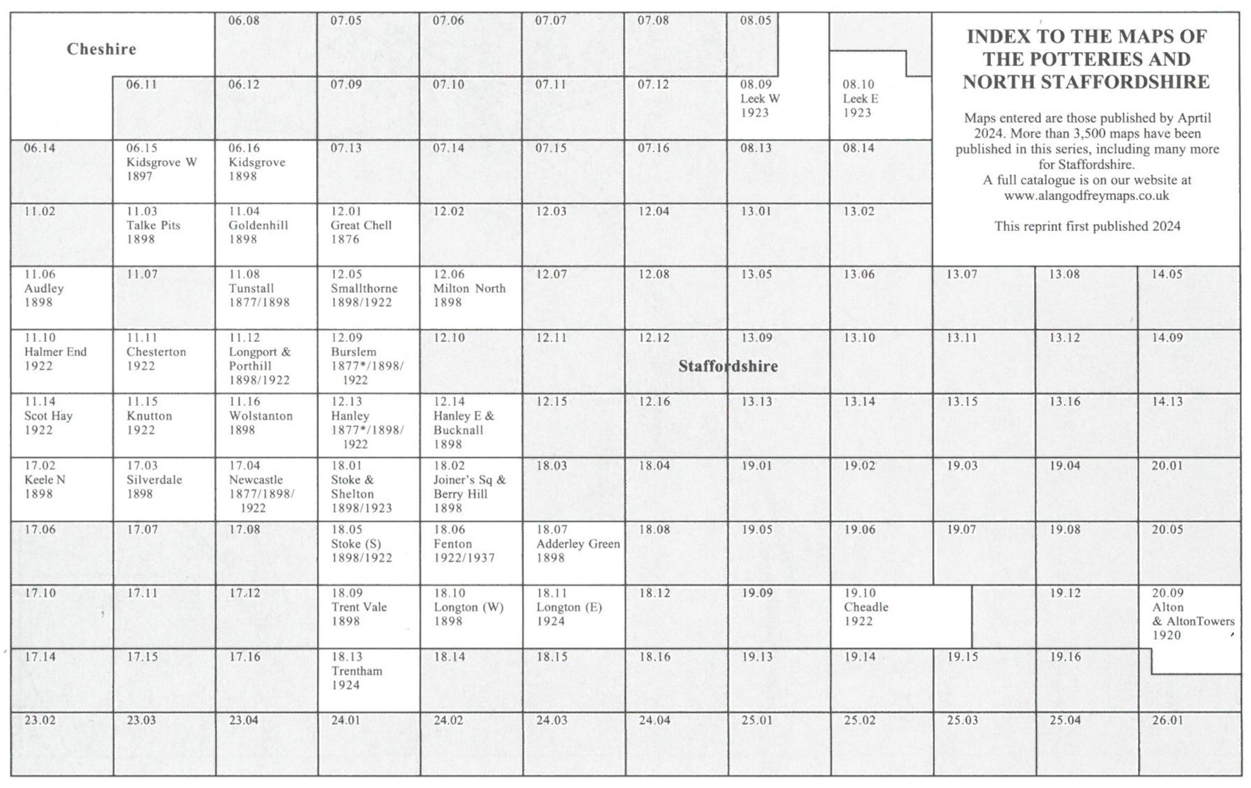
Here is an index map for The Potteries and Newcastle maps.
 The area is also covered by the following Inch to the Mile map:
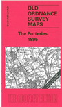
123 The Potteries 1895 - publ 2005; intro by Malcolm Nixon
 Most maps in the Godfrey Edition are taken from the 25 inch to the mile map and reduced to about 15 inches to the mile.
For a full list of English maps, return to the England page
Most maps in the Godfrey Edition are taken from the 25 inch to the mile map and reduced to about 15 inches to the mile.
For a full list of English maps, return to the England page
You can order maps direct from our On-line Mapshop.
Alan Godfrey Maps, Prospect Business Park, Leadgate, Consett, DH8 7PW. Tel 01207 583388
The Godfrey Edition / sales@alangodfreymaps.co.uk / 9 January 2024