
Old Ordnance Survey Maps of Northamptonshire
We have a range of detailed maps for Northamptonshire towns and we also cover the whole county at the Inch to the Mile scale. Here are the details.
All maps are available from our On-line Mapshop.
Northamptonshire County Council was formed in 1889. At the same time the Soke of Peterborough became an independent county and its maps are listed on a separate page.
For a summary of the county's administrative history go to This Page.
The following maps are all taken from the OS 25" maps and reduced to a scale of approximately 15 inches to the mile. Each map includes an introduction.
 These are the maps we publish for towns in Northamptonshire:
17.03 Corby 1899 -published 2001; intro by Barrie Trinder
19.05 Oundle 1899-published 2025; intro by Barrie Trinder
24.03 Desborough 1924-published 2026; intro by Barrie Trinder
24.08 Rothwell 1924-published 2002; intro by Barrie Trinder
25.10 Kettering North 1899 -published 1999; intro by Barrie Trinder
25.14 Kettering South 1899 -published 1998; intro by Barrie Trinder
26.15 Thrapston 1899 -published 2001; intro by Barrie Trinder
35.12 Braunston 1899-published 2025; intro by Barrie Trinder
39.07 Wellingborough 1899 -published 1998; intro by Barrie Trinder
40.01 Irthlingborough 1924 -published 2005; intro by Barrie Trinder
40.05 Higham Ferrers 1924 -published 2005; intro by Barrie Trinder
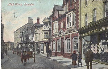
40.09 Rushden (West) 1923 -published 2005; intro by Barrie Trinder
40.10 Rushden (East) 1923 -published 2005; intro by Barrie Trinder
43.12 Weedon Bec 1899-published 2026; intro by Barrie Trinder
45.01 Kingsthorpe 1924 -published 2025; intro by Barrie Trinder
45.05a Northampton North 1899 -published 2000; intro by Barrie Trinder
45.05b Northampton North 1924 -published 2025; intro by Barrie Trinder
45.09a Northampton 1899 -published 1996; intro by Elizabeth Lockwood
45.09b Northampton 1924 -published 2025; intro by Barrie Trinder
56.06 Towcester 1899 -published 1999; intro by Barrie Trinder
62.06 King's Sutton 1920 -published 2025; intro by Barrie Trinder
63.02 Brackley 1920 -published 2005; intro by Barrie Trinder
The county is also covered in our series of One Inch Maps; here are the principal sheets.
158 Peterborough & District 1908 - published 2006; intro by Barrie Trinder. Includes a map of Deeping St James
170 Market Harborough & District 1905 - published 2004; intro by Steph Mastoris. Includes a map of Lubenham
171 Rockingham Forest & Kettering 1905 - published 2001; intro by Barrie Trinder. Includes a map of Rushton
185 Central Northants 1906 - published 2005; intro by Barrie Trinder. Includes a map of Weedon Beck
186 Wellingborough, Rushden & District 1897 - published 2000; intro by Barrie Trinder. Includes a map of Finedon
201 Kineton & Banbury 1893 - published 2003; intro by Barrie Trinder. Includes a map of Kineton
202 Towcester & District 1899 - published 2003; intro by Barrie Trinder. Includes a map of Blisworth
Follow this link for further details of the Inch to the Mile series.
 For maps of Peterborough go to the Soke of Peterborough page.
Most maps in the Godfrey Edition are taken from the 25 inch to the mile map and reduced to about 15 inches to the mile.
For a full list of English maps, return to the England page
For maps of Peterborough go to the Soke of Peterborough page.
Most maps in the Godfrey Edition are taken from the 25 inch to the mile map and reduced to about 15 inches to the mile.
For a full list of English maps, return to the England page
This list shows all our maps for the county. We try to keep a full range in print but inevitably some titles fall out of print from time to time.
These are noted in our On-line Mapshop.
Alan Godfrey Maps, Prospect Business Park, Leadgate, Consett, DH8 7PW. Tel 01207 583388
The Godfrey Edition / sales@alangodfreymaps.co.uk / 2 January 2026
 These are the maps we publish for towns in Northamptonshire: