
Old Ordnance Survey Inch to the Mile Maps
These maps normally cover an area of about 18 miles by 12 miles and are especially good at showing railways, roads and canals, and at giving
a broad view of a wider area. Each includes an introduction and a more detailed map of a small town or village.
They are available through our On-line Mapshop
 Here is information about Sheet 171:
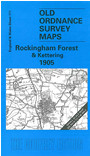
One Inch Sheet 171 Rockingham Forest & Kettering 1905 - published 2001; intro by Barrie Trinder. ISBN.978-1-84151-345-4
This One Inch to the Mile map covers much of NE Northants, including the area known as Rockingham Forest. Smaller areas of Huntingdonshire, Leicestershire and Rutland are
also included. Coverage stretches from Rushton eastward to Hemington and Winwick, and from Blatherwycke Park southward to
Kettering and Thrapston. The other town shown is Oundle, served by the LNWR Northampton to Peterborough line, which runs through the map. On the back we include an extract from Northants Sheet 25.01, showing the village of
Rushton in 1899.
It is not possible to list the many hamlets, farmsteads and other topographical features shown on these maps. However, you might find it useful if we here list the majority of the principal villages
and church parishes that are included on this map. Links are given for those for which detailed large-scale maps are also available.
Huntingdonshire: Elton, Old Weston, Winwick.
Leicestershire: Bringhurst, Drayton, Great Easton.
Northamptonshire: Aldwinkle St Peter, Apethorpe, Armston, Ashton, Barnwell All Saints, Barnwell St Andrew, Barton Seagrave, Benefield, Blatherwycke, Brigstock, Bulwick, Clapton, Corby,
Cotterstock, Cottingham, Cranford St Andrew, Deene, Deenethorpe, East Carlton, Fotheringhay, Geddington, Glapthorn, Grafton Underwood, Great Oakley, Great Weldon, Gretton, Hemington, Islip, Kettering, Laxton,
Little Oakley, Little Weldon, Lowick, Lutton, Middleton, Nassington, Newton, Oundle, Pilton, Polebrook, Rockingham, Rushton, Slipton, Southwick, Stanion, Stoke Doyle, Sudborough, Tansor, Thorpe Malsor, Thrapston,
Thurning, Titchmarsh, Twywell, Wadenhoe, Warkton, Warmington, Weekley, Woodnewton.
Rutland: Caldecott.
Index maps are available showing the areas covered by the Inch to the Mile maps. Go to This page
You can order maps direct from our On-line Mapshop. For a full list of Inch to the Mile maps go to the Inch to the Mile page,
where you will also find details of prices. For information on the rest of the series, go to The Index Page.
Alan Godfrey Maps, Prospect Business Park, Leadgate, Consett, Co Durham, DH8 7PW / sales@alangodfreymaps.co.uk / 16 April 2011