
Old Ordnance Survey Maps of Kirklees MBC
This is our coverage of Kirklees, historically part of the West Riding of Yorkshire. The Metropolitan Borough of Kirklees was formed in 1974 with
the amalgamation of the County Borough of Dewsbury, County Borough of Huddersfield, Batley Borough, Spenborough Borough, Colne Valley Urban District, Denby Dale Urban District,
Heckmondwike Urban District, Holmfirth Urban District, Kirkburton Urban District, Meltham Urban District, and Mirfield Urban District.
At the same time it became part of the new West Yorkshire Metropolitan County. Since 1986 it has been a unitary authority.
All maps are available from our On-line Mapshop.
The following titles are taken from the OS 25" maps and reduced to a scale of approximately 14 inches to the mile.
Each covers an area of a mile and a half by one mile, and includes an introduction.
 These are the maps for Kirklees in our Yorkshire series:
217.13 East Bierley 1905 - published 2015; intro by Ruth Strong
231.04a Oakenshaw, Low Moor & Wyke 1893 - published 2017; intro by Ruth Strong  231.04b Oakenshaw, Low Moor & Wyke 1905 - published 2015; intro by Alan Godfrey
232.01 Hunsworth 1905 - published 2014; intro by Alan Godfrey
232.02 Birkenshaw & Oakwell Hall 1905 - published 2014; intro by Alan Godfrey
232.03 Gildersome Street 1906 - published 2013; intro by Alan Godfrey
232.05 Cleckheaton 1905 - published 2003; intro by John Hargreaves
232.06 Gomersal & Birstall 1905 - published 2004; intro by John Hargreaves
232.07 Upper Batley 1906 - published 2012; intro by Alan Godfrey
232.08 Morley (South) 1906 - published 2013; intro by Alan Godfrey
232.09 Liversedge (Hightown) & South Cleckheaton 1905 - published 2015; intro by Alan Godfrey
232.10 Liversedge & North Heckmondwike 1905 - published 2003; intro by Michael Popplewell
232.11a Batley 1892 - published 2012; intro by Alan Godfrey
232.11b Batley 1905 - published 1993; intro by Gordon Dickinson
232.12 Lower Soothill & Woodkirk 1892 - published 2012; intro by Alan Godfrey
232.13 Roberttown & Hartshead 1905 - published 2014; intro by Alan Godfrey
232.14 Heckmondwike 1905 - published 2005; intro by John Hargreaves
232.15a Staincliffe & Batley Carr 1892 - published 2013; intro by Alan Godfrey
232.15b Staincliffe & Batley Carr 1906 - published 1994; intro by Gordon Dickinson
232.16 Hanging Heaton 1892 - published 2012; intro by Alan Godfrey
246.05 Holywell Green 1907 - published 2011; intro by John Hargreaves
246.10 Huddersfield (Lindley cum Quarmby) 1905 - published 2009; intro by Edgar Holroyd-Doveton
246.11 Huddersfield (North) 1905 - published 1990; intro by Gordon Dickinson
246.14 Huddersfield (West) 1905 - published 2008; intro by Edgar Holroyd-Doveton
246.15a Central Huddersfield 1889 - published 2011; intro by Alan Godfrey.
246.15b Central Huddersfield 1905 - published 1990; intro by Gordon Dickinson
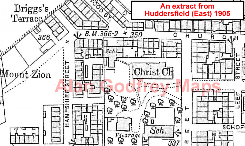
246.16 Huddersfield (East) 1905 - published 2010; intro by Alan Godfrey
247.01 Mirfield (NW): Battyeford & Roe Head 1905 - published 2008; intro by Alan Godfrey
247.02 Mirfield (NE): Wellhouse & Northorpe 1905 - published 2008; intro by Alan Godfrey
247.03a Dewsbury 1889 - published 2011; intro by Alan Godfrey.
247.03b Dewsbury 1905 - published 1994; intro by Gordon Dickinson
247.04 Earlsheaton 1905 - published 2009; intro by Alan Godfrey
247.05 Mirfield (SW) 1930 - published 2008; intro by Alan Godfrey
247.06 Mirfield & Ravensthorpe 1905 - published 2008; intro by Alan Godfrey
247.07 Thornhill Lees 1905 - published 2008; intro by Alan Godfrey
247.08 Ossett (SW) & Combs 1905 - published 2009; intro by Alan Godfrey
231.04b Oakenshaw, Low Moor & Wyke 1905 - published 2015; intro by Alan Godfrey
232.01 Hunsworth 1905 - published 2014; intro by Alan Godfrey
232.02 Birkenshaw & Oakwell Hall 1905 - published 2014; intro by Alan Godfrey
232.03 Gildersome Street 1906 - published 2013; intro by Alan Godfrey
232.05 Cleckheaton 1905 - published 2003; intro by John Hargreaves
232.06 Gomersal & Birstall 1905 - published 2004; intro by John Hargreaves
232.07 Upper Batley 1906 - published 2012; intro by Alan Godfrey
232.08 Morley (South) 1906 - published 2013; intro by Alan Godfrey
232.09 Liversedge (Hightown) & South Cleckheaton 1905 - published 2015; intro by Alan Godfrey
232.10 Liversedge & North Heckmondwike 1905 - published 2003; intro by Michael Popplewell
232.11a Batley 1892 - published 2012; intro by Alan Godfrey
232.11b Batley 1905 - published 1993; intro by Gordon Dickinson
232.12 Lower Soothill & Woodkirk 1892 - published 2012; intro by Alan Godfrey
232.13 Roberttown & Hartshead 1905 - published 2014; intro by Alan Godfrey
232.14 Heckmondwike 1905 - published 2005; intro by John Hargreaves
232.15a Staincliffe & Batley Carr 1892 - published 2013; intro by Alan Godfrey
232.15b Staincliffe & Batley Carr 1906 - published 1994; intro by Gordon Dickinson
232.16 Hanging Heaton 1892 - published 2012; intro by Alan Godfrey
246.05 Holywell Green 1907 - published 2011; intro by John Hargreaves
246.10 Huddersfield (Lindley cum Quarmby) 1905 - published 2009; intro by Edgar Holroyd-Doveton
246.11 Huddersfield (North) 1905 - published 1990; intro by Gordon Dickinson
246.14 Huddersfield (West) 1905 - published 2008; intro by Edgar Holroyd-Doveton
246.15a Central Huddersfield 1889 - published 2011; intro by Alan Godfrey.
246.15b Central Huddersfield 1905 - published 1990; intro by Gordon Dickinson
246.16 Huddersfield (East) 1905 - published 2010; intro by Alan Godfrey
247.01 Mirfield (NW): Battyeford & Roe Head 1905 - published 2008; intro by Alan Godfrey
247.02 Mirfield (NE): Wellhouse & Northorpe 1905 - published 2008; intro by Alan Godfrey
247.03a Dewsbury 1889 - published 2011; intro by Alan Godfrey.
247.03b Dewsbury 1905 - published 1994; intro by Gordon Dickinson
247.04 Earlsheaton 1905 - published 2009; intro by Alan Godfrey
247.05 Mirfield (SW) 1930 - published 2008; intro by Alan Godfrey
247.06 Mirfield & Ravensthorpe 1905 - published 2008; intro by Alan Godfrey
247.07 Thornhill Lees 1905 - published 2008; intro by Alan Godfrey
247.08 Ossett (SW) & Combs 1905 - published 2009; intro by Alan Godfrey
 259.11 Marsden 1904 - published 2002; intro by Alan Godfrey
260.03 Huddersfield (South) 1905 - published 1996; intro by Gordon Dickinson
260.09 Meltham (North) & Helme 1904 - published 2013; intro by Edgar Holroyd-Doveton
260.13 Meltham (South) 1904 - published 2013; intro by Edgar Holroyd-Doveton
272.03 Holmfirth 1904 - published 1999; intro by G C Dickinson
259.11 Marsden 1904 - published 2002; intro by Alan Godfrey
260.03 Huddersfield (South) 1905 - published 1996; intro by Gordon Dickinson
260.09 Meltham (North) & Helme 1904 - published 2013; intro by Edgar Holroyd-Doveton
260.13 Meltham (South) 1904 - published 2013; intro by Edgar Holroyd-Doveton
272.03 Holmfirth 1904 - published 1999; intro by G C Dickinson
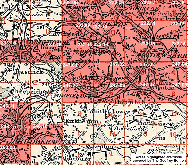
You might find this Index Map useful for the Dewsbury area
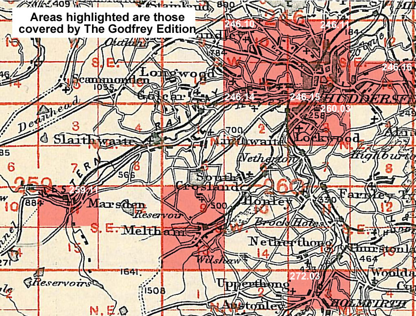
You might find this Index Map useful for the Huddersfield area.
The area is also covered in our Inch to the Mile series:
Sheet 77 Calderdale & Huddersfield 1902- published 2000; intro by David Hey. Includes a map of Almondbury
For further details of our One Inch Maps, visit the One Inch page.
 Most maps in the Godfrey Edition are taken from the 25 inch to the mile map and reduced to about 15 inches to the mile.
For a full list of English maps, return to the Yorkshire page
You can order maps direct from our On-line Mapshop.
Most maps in the Godfrey Edition are taken from the 25 inch to the mile map and reduced to about 15 inches to the mile.
For a full list of English maps, return to the Yorkshire page
You can order maps direct from our On-line Mapshop.
Alan Godfrey Maps, Prospect Business Park, Leadgate, Consett, DH8 7PW. Tel 01207 583388
The Godfrey Edition / sales@alangodfreymaps.co.uk / 5 December 2017
 259.11 Marsden 1904 - published 2002; intro by Alan Godfrey