We have very good coverage for Kirklees Metropolitan Borough, which was formed in 1974 from the Dewsbury and Huddersfield County Boroughs, Batley and Spenborough Municipal Boroughs, and Colne Valley, Denby Dale, Heckmondwike, Holmfirth, Kirkburton, Meltham and Mirfield Urban Districts.
The following titles are all taken from the OS 25" maps and reduced to a scale of approximately 14 inches to the mile. Each covers an area of a mile and a half by one mile, and includes an introduction. Click on the links below for further details. All maps are available from our On-line Mapshop.
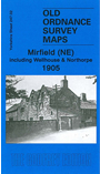 Here are the details of maps for Mirfield NE:

This detailed map covers the NE area of Mirfield, including Wellhouse, Northorpe and the area known as Little London City. Features include both Northorpe stations, Spring Place Mills, Northorpe Hall, Highfield House, Bolderstone Hall, Primrose, Crossley Hill, Low Fold, Towngate, Wellhouse Moravian chapel, Upper Crossley, Dark Lane Colliery. On the reverse we include railway timetables for the Bradford-Wakefield and Halifax-Mirfield lines.
The map links up with sheets 232.14 Heckmondwike to the north, 247.01 Mirfield NE to the west, 247.03 Dewsbury to the east and 247.06 Mirfield & Ravensthorpe to the south.