We have very good coverage for Kirklees Metropolitan Borough, which was formed in 1974 from the Dewsbury and Huddersfield County Boroughs, Batley and Spenborough Municipal Boroughs, and Colne Valley, Denby Dale, Heckmondwike, Holmfirth, Kirkburton, Meltham and Mirfield Urban Districts.
The following titles are all taken from the OS 25" maps and reduced to a scale of approximately 14 inches to the mile. Each covers an area of a mile and a half by one mile, and includes an introduction. Click on the links below for further details. All maps are available from our On-line Mapshop.
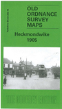 Here are the details of maps for Heckmondwike:

This detailed map covers much of Heckmondwike and the area to the south, with coverage southward to Liversedge Park Farm and westward to Balm Field and the Huddersfield Road. The many features include the disused Park Farm Colliery, Lighthouse Tannery, Dewsbury Moor House, Kilpin Hill Mills, St James church, Market Place, LNWR and LYR stations with railway approaches, Flush Mills, Walkley Mills, Spen Vale Mills, Norristhorpe, Swashland, Milton Square, Headland, Liversedge Hall, Strawberry Bank Colliery, Spen Valley Carpet Works, Wellington Mills, High Street, tramways etc. An 1889 directory of Heckmondwike is included on the reverse.
The map links up with sheet 232.10 Liversedge to the north, 232.13 Roberttown to the west, 232.15 Staincliffe to the east and 247.02 Mirfield NE to the south.