We have very good coverage for Kirklees Metropolitan Borough, which was formed in 1974 from the Dewsbury and Huddersfield County Boroughs, Batley and Spenborough Municipal Boroughs, and Colne Valley, Denby Dale, Heckmondwike, Holmfirth, Kirkburton, Meltham and Mirfield Urban Districts.
The following titles are all taken from the OS 25" maps and reduced to a scale of approximately 14 inches to the mile. Each covers an area of a mile and a half by one mile, and includes an introduction. Click on the links below for further details. All maps are available from our On-line Mapshop.
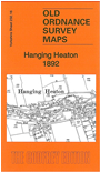 Here are the details of maps for Hanging Heaton:

This detailed map covers an area just east of Batley and Dewsbury which includes Hanging Heaton, Shaw Cross and Chidswell.
Features include Shaw Cross Colliery, Gawthorpe Reservoir, Owl Mills, Owl House, Soothill Colliery with tramway, St Paul's church, Greenhill Mills, Brewery, Gas Works, Chickenley Heath Branch. Directories of Hanging Heaton and Soothill are included on the reverse.
The map links up with sheet 232.12 Lower Soothill to the north, 232.15 Staincliffe to the west, 247.04 Earlsheaton to the south.