Old Ordnance Survey Maps of Cornwall
We have a range of detailed maps for Cornwall's towns and we also cover the whole county at the Inch to the Mile scale.
All maps are available from our On-line Mapshop.
Cornwall County Council was formed in 1889. There was a reorganisation in 1974, with a county council and six Districts; Caradon, Carrick, Kerrier,
North Cornwall, Penwith, and Restormel. However, in 2009 the Districts were abolished and Cornwall became a unitary authority.
The Isles of Scilly is a unitary authority in its own right.
See This Page for a summary of the county's local government history.
 These are the maps we publish for Cornwall:
10.07 Boscastle 1905 - published 2006; intro by Tom Greeves
10.13 Tintagel 1905 - published 2007; intro by Tom Greeves
14.11 Camelford 1905 - published 2006; intro by Joanna Raymond-Barker
25.07 Wadebridge 1906 - published 2009; intro by Richard Oliver
30.01 Gunnislake (North) 1905 - published 2004; intro by Tom Greeves
30.05 Gunnislake (South) & Albaston 1905 - published 2004; intro by Tom Greeves
34.02 Bodmin 1906 - published 2009; intro by Richard Oliver
39.03 Newquay (West) 1933 - published 2014; intro by Tony Clifford
39.04 Newquay (East) 1933 - published 2014; intro by Tony Clifford
50.08 St Austell 1933 - published 2011; intro by Richard Oliver
51.02 St Blazey 1933 - published 2014; intro by Tony Clifford
51.06 St Blazey Gate 1933 - published 2014; intro by Tony Clifford
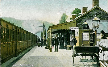
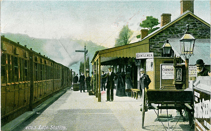
53.02 Looe 1905 - published 2002; intro by Alan Godfrey
57.12 Truro (North) 1906 - published 2014; intro by Tony Clifford
57.16 Truro (South) 1906 - published 2014; intro by Tony Clifford
59.12 Mevagissey 1905 see One Inch 353
61.12 St Ives 1906 - published 2012; intro by Tony Clifford
63.07 Redruth 1906 - published 1999; intro by Terry Knight
63.09 Camborne 1906 - published 2015; intro by Tony Clifford
69.01 Hayle & Lelant 1876 - published 2007; intro by Tony Clifford
71.07 Penryn 1906 - published 2005; intro by Tony Clifford
71.12 Falmouth 1878 - published 2012; intro by Richard Oliver
74.02 Penzance 1877 - published 2013; intro by Tony Clifford  76.10 Helston 1906 - published 2005; intro by Tony Clifford
We also cover the whole county in our Inch to the Mile series. These are the principal maps for the county:
307/308 The Hartland Peninsula 1894 published 2009; intro by Richard Oliver. Includes a map of Stratton
322 Trevalga, Trevena & Tintagel Head 1894-1908 published 2010; intro by Richard Oliver. Includes a map of Trevalga.
323 Holsworthy & the Upper Tamar 1894 published 2009; intro by Richard Oliver. Includes a map of Holsworthy
335/346 Newquay & Trevose Head 1894 published 2009; intro by Richard Oliver. Includes a map of St Agnes.
336 Padstow, Wadebridge & Bodmin Moor 1905 published 2009; intro by Richard Oliver. Includes a map of Padstow.
337 Middle Tamar & Caradon 1894 published 2001; intro by Richard Oliver. Includes a map of Calstock.
347 Bodmin, Lostwithiel & The China Clay District 1894 published 2009; intro by Richard Oliver. Includes a map of Lostwithiel.
348 Plymouth to Polperro 1894 published 2005; intro by Tom Greeves. Includes a map of Polperro.
351 Penzance & St Ives Bay 1888 published 2001; intro by Peter Waverley. Includes a map of St Just.
352 Fal Estuary & Camborne 1890 published 2000; intro by Kim Cooper. Includes a map of Praze-an-Beeble.
353 Mevagissey 1894-1905 published 2009; intro by Richard Oliver. Includes a detailed map of Mevagissey.
357/360 Isles of Scilly 1896 published 2008; intro by Tom Greeves. Includes a map of Hugh Town.
359 The Lizard 1894 published 2009; intro by Richard Oliver. Includes a map of Manaccan.
For further details visit the One Inch page.
 Most maps in the Godfrey Edition are taken from the 25 inch to the mile map and reduced to about 15 inches to the mile.
Return to the page for adjacent counties. For a full list of English maps, return to the England page
You can order maps direct from our On-line Mapshop.
This list shows all our maps for the area. We try to keep a full range in print but inevitably some titles fall out of print from time to time.
These are noted in our On-line Mapshop.
Most maps in the Godfrey Edition are taken from the 25 inch to the mile map and reduced to about 15 inches to the mile.
Return to the page for adjacent counties. For a full list of English maps, return to the England page
You can order maps direct from our On-line Mapshop.
This list shows all our maps for the area. We try to keep a full range in print but inevitably some titles fall out of print from time to time.
These are noted in our On-line Mapshop.
Alan Godfrey Maps, Prospect Business Park, Leadgate, Consett, DH8 7PW. Tel 01207 583388
The Godfrey Edition / sales@alangodfreymaps.co.uk / 13 January 2018
 These are the maps we publish for Cornwall: