
Old Ordnance Survey Maps of the City of Bradford MBC
This is our coverage of Bradford, historically part of the West Riding of Yorkshire.
Bradford became a Municipal Borough in 1847, a County Borough in 1889 and was granted City status in 1897. In 1899 its
boundaries were extended to include Eccleshill, Idle, North Bierley, Thornton, Tong and Wyke; In 1930 Clayton was added. The present
Metropolitan Borough was formed in 1974 with the amalgamation of the City of Bradford with Keighley Borough, Baildon Urban District, Bingley Urban District, Denholme Urban District, Ilkley Urban District, Shipley Urban District,
Silsden Urban District and some outlying villages including Queensbury. At the same time it became part of the new West Yorkshire Metropolitan County. Since 1986 it has been a unitary authority.
All maps are available from our On-line Mapshop.
 The following titles are taken from the OS 25" maps and reduced to a scale of approximately 14 inches to the mile. Each includes an introduction.
The following maps are taken from the highly detailed Five-foot plans, and reduced to a scale of A Yard to the Mile.
They show the area in even greater detail.
Bradford 5 Central Bradford (North) 1848-66 - published 2024; intro by Barrie Trinder
Bradford 8 Central Bradford (South) 1848-66 - published 2024; intro by Barrie Trinder
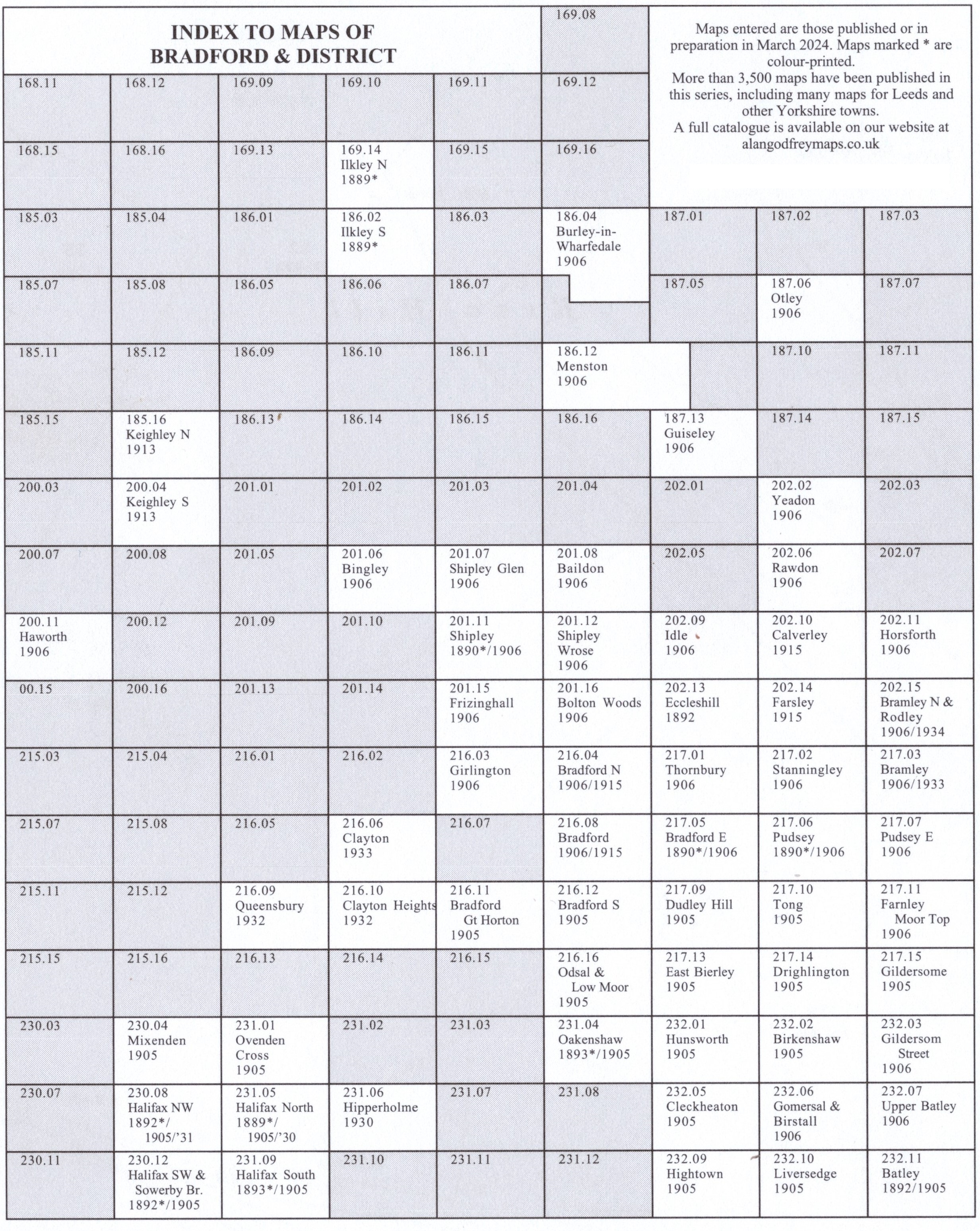
Here is a Bradford index grid.
The area is also covered in our smaller scale Inch to the Mile maps. This is the principal map for the area:
Sheet 69 Mid Airedale 1858-70- published 1998; intro by Gordon Dickinson. Includes a map of Bramhope.
For further details of our One Inch Maps, visit the One Inch page.
 Most maps in the Godfrey Edition are taken from the 25 inch to the mile map and reduced to about 15 inches to the mile.
For a full list of English maps, return to the England page
You can order maps direct from our On-line Mapshop.
This list shows all te principal maps for the borough. We try to keep a full range in print but inevitably some titles fall out of print from time to time.
These are noted in our On-line Mapshop.
Most maps in the Godfrey Edition are taken from the 25 inch to the mile map and reduced to about 15 inches to the mile.
For a full list of English maps, return to the England page
You can order maps direct from our On-line Mapshop.
This list shows all te principal maps for the borough. We try to keep a full range in print but inevitably some titles fall out of print from time to time.
These are noted in our On-line Mapshop.
Alan Godfrey Maps, Prospect Business Park, Leadgate, Consett, DH8 7PW. Tel 01207 583388
The Godfrey Edition / sales@alangodfreymaps.co.uk / 15 April 2025
