
Old Ordnance Survey Maps of Wigan
This is our coverage of Wigan. Wigan, historically in Lancashire, was a Borough in the 13th century and was made a County Borough in 1889; it annexed Pemberton Urban District in 1904.
Leigh became a County Borough in 1899. The current Wigan Metropolitan Borough was created in 1974 with the amalgamation of Leigh County Borough, Wigan County Borough,
Abram Urban District, Aspull Urban District, Atherton Urban District, Hindley Urban District, Ince-in-Makerfield Urban District, Orrell Urban District, Standish Urban District, together with parts of
Ashton-in-Makerfield, Billinge & Winstanley, and Golborne Urban Districts, and some parishes from Wigan Rural District. At the same time it became part of the new Greater Manchester
Metropolitan County. It is now a unitary authority.
All maps are available from our On-line Mapshop.
The following titles are taken from the OS 25" maps and reduced to a scale of approximately 14 inches to the mile.
They are extremely detailed, showing individual houses, details such as railway tracks, pathways,
pubs, factories and even minutiae such as fountains and signal posts. Each covers an area of a mile and a half by one mile, and includes an introduction.
 These are the maps for Wigan in our Lancashire series:
85.11 Standish 1908 - publ 2011; intro by Alan Godfrey
85.12 Red Rock n& Worthington Lakes 1908 - published 2013; intro by Derrick Pratt
85.15 Standish (Boar's Head) 1907 - publ 2011; intro by Alan Godfrey
85.16 Haigh Hall 1907 - publ 2012; intro by Alan Godfrey
86.09 Blackrod 1907 - published 2013; intro by Derrick Pratt
86.13 Haigh & Aspull Moor 1907 - publ 2011; intro by Alan Godfrey
86.14 Hilton House 1907 - published 2013; intro by Derrick Pratt
93.03 Wigan (NW) 1907 - publ 2006; intro by Alan Godfrey
93.02 Gathurst & Crooke 1907 - publ 2009; intro by Alan Godfrey
93.03 Wigan (NW) 1907 - publ 2006; intro by Alan Godfrey
93.04 Wigan North 1907 - published 2002; introduction by Alan Godfrey
93.05 Upholland 1907 - publ 2009; intro by Alan Godfrey
93.06 Orrell Post & Kitt Green 1907 - publ 2010; intro by Alan Godfrey
93.07 Wigan West 1908 - publ 1988, 2nd Ed 2007; intro by Alan Godfrey
93.08a Wigan 1892 - publ 2021; intro by Kay Parrott
93.08b Wigan 1907 - publ 1988, 2nd Ed 2007; intro by Alan Godfrey
93.08c Wigan 1928 - publ 2007; intro by Alan Godfrey
93.09 Upholland (South) 1907 - publ 2010; intro by Alan Godfrey
93.10 Lamberhead Green & Orrell Mount 1907 - publ 2009; intro by Alan Godfrey
93.11a Pemberton 1907 - publ 2000; intro by Paul Hindle
93.11b Pemberton 1927 - publ 2010; intro by Alan Godfrey
93.12a Ince in Makerfield 1907 - publ 2012; intro by Derrick Pratt
93.12b Ince in Makerfield 1927 - publ 2001; intro by Alan Godfrey
93.14 Winstanley 1907 - publ 2009; intro by Alan Godfrey
93.15 Wigan (Marus Bridge) 1907 - publ 2009; intro by Alan Godfrey
93.16 Ince Moss 1907 - publ 2001; intro by Alan Godfrey
94.01 Aspull (South) 1928 - publ 2011; intro by Alan Godfrey
94.05 Kirkless & Hindley Hall 1907 - publ 2001; intro by Alan Godfrey
94.06 Hart Common & Dobb Brow 1907 - published 2013; intro by Derrick Prat
94.09a Hindley 1892 - publ 2021; intro by Alan Godfrey  94.09b Hindley 1907 - publ 2001; intro by Alan Godfrey
94.10 Hindley Green (North) 1907 - publ 2001; intro by Alan Godfrey
94.11 Daisy Hill & Bag Lane 1907 - publ 2015; intro by Alan Godfrey
94.12 Atherton (NE) 1907 - publ 2009; intro by Alan Godfrey
94.13 Platt Bridge & Bickershaw Lane 1906 - publ 2002; intro by Alan Godfrey
94.14 Hindley Green 1906 - publ 2010; intro by Alan Godfrey
94.15 Atherton SW & Howe Bridge 1906 - published 2003; intro by Paul Hindle
94.16 Tyldesley & Atherton (SE) 1905 - publ 2003; intro by Alan Godfrey
95.13 Cleworth Hall 1907 - published 2007; intro by Alan Godfrey
101.04 Bamfurlong & Bryn Gates 1906 - publ 2005; intro by Alan Godfrey
101.07 Ashton in Makerfield 1906 - publ 2004; intro by Alan Godfrey
101.08 Ashton in Makerfield (E) & Edge Green 1906 - publ 2004; intro by Alan Godfrey
101.11 Haydock (North) 1906 - publ 2010; intro by Kay Parrott
101.12 Haydock Park 1906 - publ 2010; intro by Kay Parrott
101.16 Newton-le-Willows 1906 published 2013; intro by Alan Godfrey
102.01 Abram 1906 published 2013; intro by Alan Godfrey
102.02a Westleigh 1905 - publ 2012; intro by Derrick Pratt
102.02b Westleigh 1926 - publ 2021; intro by Alan Godfrey
102.03a Leigh North 1892 - publ 2013; intro by Derrick Pratt
102.03b Leigh North 1905 - publ 1990; intro by Nick Burton
102.06 Pennington Flash & Plank Lane 1926 - publ 2021; intro by Alan Godfrey
102.07a Leigh South 1892 - publ 2013; intro by Derrick Pratt
102.07b Leigh South 1905 - publ 1990; intro by Nick Burton
102.09 Golborne 1906 published 2013; intro by Alan Godfrey
102.10 Lowton St Mary's 1925 published 2021; intro by Alan Godfrey
103.01 Boothstown & Astley Green 1904 - publ 2005; intro by Alan Godfrey
94.09b Hindley 1907 - publ 2001; intro by Alan Godfrey
94.10 Hindley Green (North) 1907 - publ 2001; intro by Alan Godfrey
94.11 Daisy Hill & Bag Lane 1907 - publ 2015; intro by Alan Godfrey
94.12 Atherton (NE) 1907 - publ 2009; intro by Alan Godfrey
94.13 Platt Bridge & Bickershaw Lane 1906 - publ 2002; intro by Alan Godfrey
94.14 Hindley Green 1906 - publ 2010; intro by Alan Godfrey
94.15 Atherton SW & Howe Bridge 1906 - published 2003; intro by Paul Hindle
94.16 Tyldesley & Atherton (SE) 1905 - publ 2003; intro by Alan Godfrey
95.13 Cleworth Hall 1907 - published 2007; intro by Alan Godfrey
101.04 Bamfurlong & Bryn Gates 1906 - publ 2005; intro by Alan Godfrey
101.07 Ashton in Makerfield 1906 - publ 2004; intro by Alan Godfrey
101.08 Ashton in Makerfield (E) & Edge Green 1906 - publ 2004; intro by Alan Godfrey
101.11 Haydock (North) 1906 - publ 2010; intro by Kay Parrott
101.12 Haydock Park 1906 - publ 2010; intro by Kay Parrott
101.16 Newton-le-Willows 1906 published 2013; intro by Alan Godfrey
102.01 Abram 1906 published 2013; intro by Alan Godfrey
102.02a Westleigh 1905 - publ 2012; intro by Derrick Pratt
102.02b Westleigh 1926 - publ 2021; intro by Alan Godfrey
102.03a Leigh North 1892 - publ 2013; intro by Derrick Pratt
102.03b Leigh North 1905 - publ 1990; intro by Nick Burton
102.06 Pennington Flash & Plank Lane 1926 - publ 2021; intro by Alan Godfrey
102.07a Leigh South 1892 - publ 2013; intro by Derrick Pratt
102.07b Leigh South 1905 - publ 1990; intro by Nick Burton
102.09 Golborne 1906 published 2013; intro by Alan Godfrey
102.10 Lowton St Mary's 1925 published 2021; intro by Alan Godfrey
103.01 Boothstown & Astley Green 1904 - publ 2005; intro by Alan Godfrey
These maps are taken from the large scale Five eet to the Mile maps:
Wigan 5 Wigan Town Centre 1847 - publ 2025; intro by Alan Godfrey
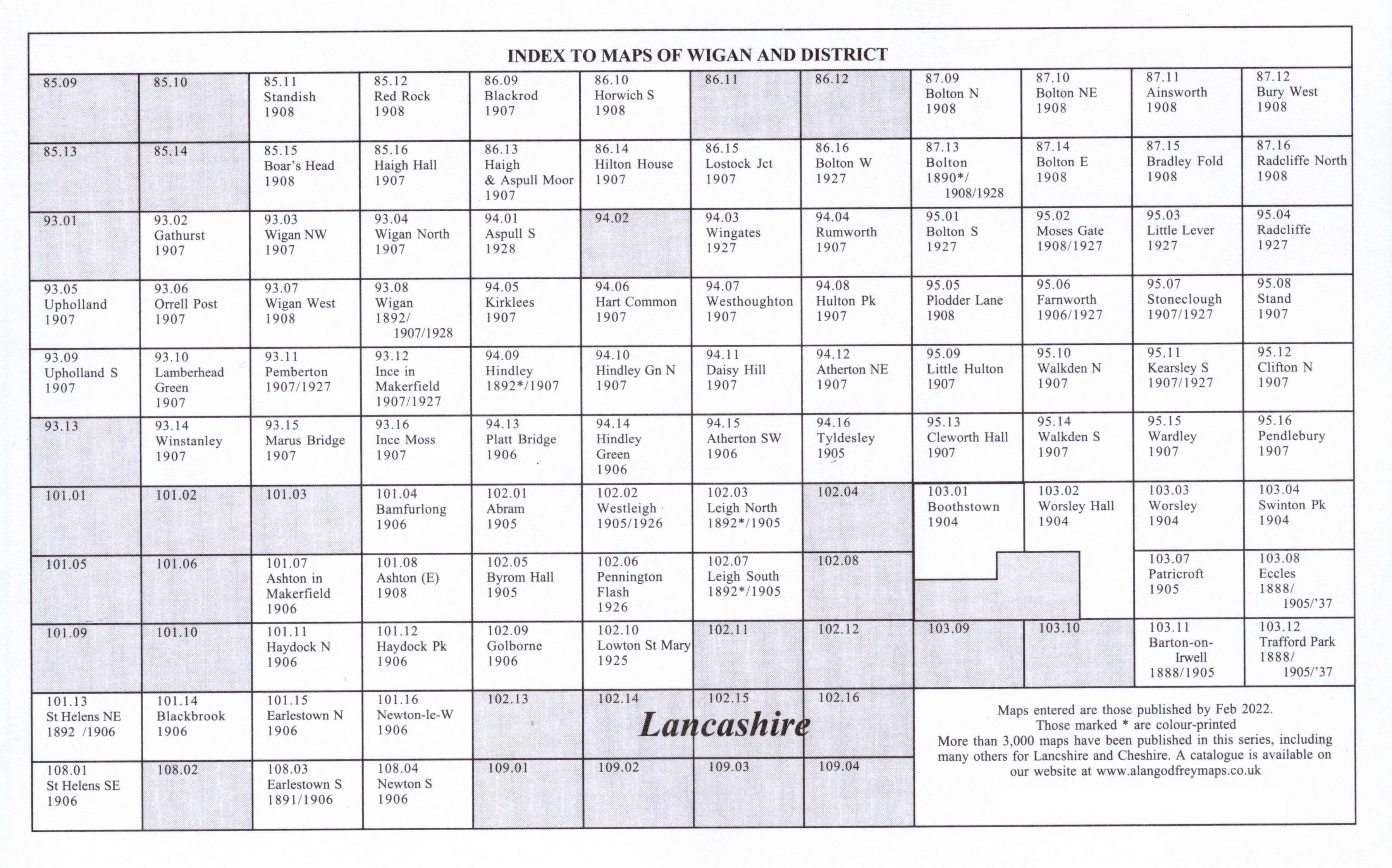
Here is an Index Map for our Wigan maps.
There is also a one inch to the mile map covering the wider area:
84 South Lancashire Coalfield 1907 - published 1999; Introduction by Alan Crosby.
For further details of our Inch to the Mile maps go to the One Inch page
 Most maps in the Godfrey Edition are taken from the 25 inch to the mile map and reduced to about 15 inches to the mile.
For a full list of English maps, return to the England page.
You can order maps direct from our On-line Mapshop.
Most maps in the Godfrey Edition are taken from the 25 inch to the mile map and reduced to about 15 inches to the mile.
For a full list of English maps, return to the England page.
You can order maps direct from our On-line Mapshop.
Alan Godfrey Maps, Prospect Business Park, Leadgate, Consett, DH8 7PW. Tel 01207 583388
The Godfrey Edition / sales@alangodfreymaps.co.uk / 21 March 2025