
Old Ordnance Survey Maps of Ealing
We have very good coverage for the London Borough of Ealing, which was formed in 1965 from the Municipal Boroughs of Acton, Ealing and Southall. The area includes maps
from both our London and Middlesex series, which link up with each other.
All maps are available from our On-line Mapshop.
The following titles are all taken from the OS 25" maps and reduced to a scale of approximately 14 inches to the mile.
They are extremely detailed, showing individual houses, details such as railway tracks, pathways,
pubs, factories and even minutiae such as fountains and signal posts. Each covers an area of a mile and a half by one mile, and includes an introduction.
 These are the principal maps for Ealing in our London series:
45a Perivale 1894 - published 1989, 2nd Ed 2002; intro by Peter Hounsell
45b Perivale & Pitshanger 1935 - published 2009; intro by Peter Hounsell
55a Hanwell Village 1894 - published 1994; intro by Maureen Gooding
55b Hanwell Village 1934 - published 2009; intro by Jonathan Oates
56a Ealing 1894 - published 1991; intro by Peter Hounsell
56b Ealing 1913 - published 2017; intro by Alan Godfrey
56c Ealing 1934 - published 2008; intro by Peter Hounsell
57a Acton Town & Ealing Common 1864 - published 1990; intro by Pamela Taylor
57b Ealing Common & West Acton 1894 - published 2005; intro by Jonathan Oates
57c Ealing Common & West Acton 1934 - published 2007; intro by Jonathan Oates
58a East Acton & Wormwood Scrubs 1872 - published 2005; intro by John Griffiths
58b East Acton & Wormwood Scrubs 1894 - published 2005; intro by John Griffiths
58c East Acton & Wormholt 1913 - published 1985; intro by Rosemary Clarkson
69a Hanwell & Norwood Green 1894 - published 1991, rev 2006; intro by Maureen Gooding
69b Hanwell & Norwood Green 1934 - published 2009; intro by Jonathan Oates
70a South Ealing 1894 - published 1994; intro by Alan Godfrey
70b South Ealing 1913 - published 2020; intro by Pamela Taylor
70c South Ealing 1934 - published 2007; intro by Jonathan Oates
71a South Acton & Gunnersbury 1893 - published 1990; intro by Pamela Taylor
71b South Acton & Gunnersbury Park 1913 - published 2021; intro by Pamela Taylor
71c South Acton & Gunnersbury Park 1935 - published 2007; intro by Jonathan Oates
 These are the principal maps for Ealing in our Middlesex series:
10.14 Ruislip (SE) 1940 - published 2010; intro by Peter Hounsell
10.15 South Harrow & Northolt Park 1935 - published 2009; intro by Alan Godfrey
10.16 Sudbury 1936 - published 2008; intro by Alan Godfrey
15.02 Northolt 1935 - published 2013; intro by Pamela Taylor
15.03 North Greenford 1938 - published 2008; intro by Frances Hounsell
15.04 North Perivale & South Sudbury 1935 - published 2009; intro by Peter Hounsell
15.06 Yeading 1894 - published 2002; intro by Frances & Peter Hounsell
15.07a Greenford 1896 - published 1991; intro by Frances Hounsell
15.07b Greenford 1939 - published 2008; intro by Peter Hounsell
15.10a Southall 1894 - published 2001; intro by Jonathan Oates
15.10b Southall 1935 - published 2022; intro by Deborah Cooke
15.13 Hayes (South) 1935 - published 2004; intro by John Griffiths
15.14a Southall Green 1913 - published 2006; intro by Alan A Jackson
15.14b Southall Green 1935 - published 2012; intro by Pamela Taylor
16.01 Alperton & Stonebridge 1936 - published 2008; intro by Alan Godfrey
16.05a Hanger Hill 1895 - published 1991; intro by Maureen Gooding
16.05b Park Royal & Hanger Hill 1935 - published 1935; intro by Alan A Jackson
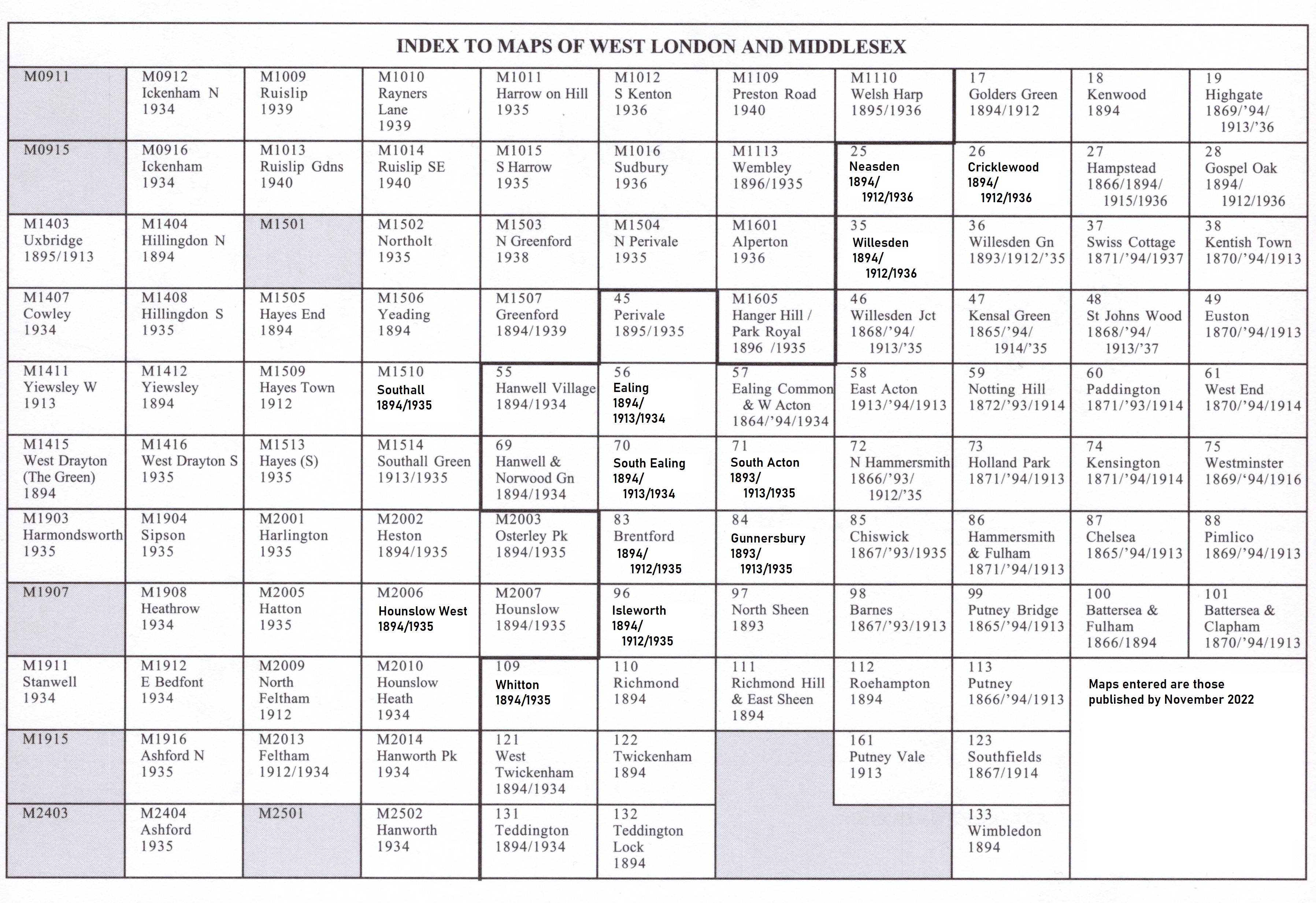
Here is an index map for the West London maps.
 Most maps in the Godfrey Edition are taken from the 25 inch to the mile map and reduced to about 15 inches to the mile.
For a full list of English maps, return to the England page
Most maps in the Godfrey Edition are taken from the 25 inch to the mile map and reduced to about 15 inches to the mile.
For a full list of English maps, return to the England page
You can order maps direct from our On-line Mapshop.
Alan Godfrey Maps, Prospect Business Park, Leadgate, Consett, DH8 7PW. Tel 01207 583388
The Godfrey Edition / sales@alangodfreymaps.co.uk / 9 March 2022