
Old Ordnance Survey Maps of Stockport MBC
This is our coverage of Stockport. Stockport, historically part of Cheshire, became a County Borough in 1889. In the early 20th century
it expanded into Lancashire by absorbing Reddish and the Heatons. The present Metropolitan Borough of Stockport was formed in 1974 as the amalgamation of the County Borough of Stockport with
Bredbury & Romiley Urban District, Cheadle & Gatley Urban District, Hazel Grove & Bramhall Urban District, and Marple Urban District. At
the same time it bceame part of Greater Manchester. Our coverage includes maps in both the Cheshire and Lancashire series.
All maps are available from our On-line Mapshop. Here are the shop links to the Lancashire series maps or
the Cheshire series maps.
The following titles are taken from the OS 25" maps and reduced to a scale of approximately 14 inches to the mile.
They are extremely detailed, showing individual houses, details such as railway tracks, pathways,
pubs, factories and even minutiae such as fountains and signal posts. Each covers an area of a mile and a half by one mile, and includes an introduction.
These are our maps for Stockport in our Cheshire series:
10.12 Bredbury (West) & Brinnington 1907 - published 2005; intro by Chris Makepeace
10.14 Heaton Mersey 1907 - published 2013; intro by Chris Makepeace
10.15 Central Stockport 1897 - published 1996; intro by Chris Makepeace
10.16 Stockport (East) 1897 - published 2009; intro by Chris Makepeace
11.09 Woodley 1897 - published 2009; intro by Chris Makepeace
11.13 Romiley 1897 - published 2002; intro by Chris Makepeace
11.14 Compstall 1907 - published 2004; intro by Chris Makepeace
18.03 Timperley 1897 - published 2009; intro by Chris Makepeace
19.01 Gatley 1897 - published 2009; intro by Chris Makepeace
19.02 Cheadle & Cheadle Heath 1897 - published 2003; intro by Chris Makepeace
19.03 Stockport (South) 1907 - published 2002; intro by Chris Makepeace
19.04 Stockport (Offerton & Foggbrook) 1907 - published 2010; intro by Chris Makepeace
19.06 Cheadle Hulme (North) 1907 - published 2014; intro by Chris Makepeace
19.07 Bramhall Grange 1907 - published 2014; intro by Chris Makepeace
19.08 Hazel Grove 1897 - published 2006; intro by Chris Makepeace
19.10 Cheadle Hulme (South) 1907 - published 2003; intro by Chris Makepeace
19.11 Bramhall (North) 1907 - published 2004; intro by Chris Makepeace
19.16 Poynton (West) 1896 - published 2012; intro by Chris Makepeace
20.13 Poynton (East) 1907 - published 2003; intro by Chris Makepeace
20.01 Marple (Rose Hill) & Chadkirk 1896 - published 2009; intro by Chris Makepeace
20.02 Marple 1896 - published 1999; intro by Chris Makepeace
20.09 High Lane (North) 1907 - published 2022; intro by Chris Makepeace
20.10 Disley (North) & High Lane 1907 - published 2007; intro by Chris Makepeace
20.13 Poynton (East) 1907 - published 2003; intro by Chris Makepeace
20.14 Disley 1907 - published 1998; intro by Chris Makepeace
20.15 Higher Disley & Furness Vale 1907 - published 2008; intro by Chris Makepeace
The following highly detailed Town Plans are taken from the Large Scale 1:1,056 map and reduced to 'A Yard to the Mile':
Stockport 5 Stockport North 1873-92 - published 2025; intro by Chris Makepeace
Stockport 8 Stockport Town Centre 1873 - published 2008; intro by Chris Makepeace
Stockport 11 Stockport Town Centre 1873-93 - published 2025; intro by Chris Makepeace
These are the maps for Stockport in our Lancashire series:
105.13a Denton West & Gorton Bridge 1891 - published 2018; intro by Chris Makepeace  105.13b Denton West 1916 - published 1996; intro by Jill Cronin
105.13c Denton West & Gorton Bridge 1934 - published 2017; intro by Alan Godfrey
111.08a Heaton Chapel 1904 - published 1998; intro by Chris Makepeace
111.08b Heaton Chapel 1916 - published 2019; intro by Chris Makepeace
111.08c Heaton Chapel 1934 - published 2019; intro by Alan Godfrey
111.10 Didsbury (Palatine Road) 1904 - published 1992; intro by Chris Makepeace
111.11 Didsbury Heaton Mersey 1904 - published 1992; intro by Chris Makepeace
111.12a Heaton Norris 1893 - published 2013; intro by Chris Makepeace
111.12b Stockport (Heaton Norris) 1916 - published 1998; intro by Chris Makepeace
111.12c Heaton Norris & Heaton Moor 1934 - published 2018; intro by Alan Godfrey
111.15a Cheadle (North) 1916 - published 1996; intro by Chris Makepeace
111.15b Cheadle (North) 1934 - published 2020; intro by Chris Makepeace
111.16a Stockport (Edgeley & Cheadle Heath) 1916 - published 2019; intro by Chris Makepeace
111.16b Stockport (Edgeley & Cheadle Heath) 1934 - published 2019; intro by Alan Godfrey
112.01 North Reddish & SW Denton 1904 - published 1994; intro by Jill Cronin
112.05 South Reddish & Brinnington 1904 - published 1997; intro by Chris Makepeace
112.06 Woodley & Haughton Dale 1917 - published 2018; intro by Chris Makepeace
112.09a Stockport (North) 1917 - published 2018; intro by Chris Makepeace
112.09b Stockport (North) 1934 - published 2018; intro by Alan Godfrey
112.13a Stockport (South) 1917 - published 2018; intro by Chris Makepeace
112.13b Stockport (South) 1934 - published 2019; intro by Alan Godfrey
105.13b Denton West 1916 - published 1996; intro by Jill Cronin
105.13c Denton West & Gorton Bridge 1934 - published 2017; intro by Alan Godfrey
111.08a Heaton Chapel 1904 - published 1998; intro by Chris Makepeace
111.08b Heaton Chapel 1916 - published 2019; intro by Chris Makepeace
111.08c Heaton Chapel 1934 - published 2019; intro by Alan Godfrey
111.10 Didsbury (Palatine Road) 1904 - published 1992; intro by Chris Makepeace
111.11 Didsbury Heaton Mersey 1904 - published 1992; intro by Chris Makepeace
111.12a Heaton Norris 1893 - published 2013; intro by Chris Makepeace
111.12b Stockport (Heaton Norris) 1916 - published 1998; intro by Chris Makepeace
111.12c Heaton Norris & Heaton Moor 1934 - published 2018; intro by Alan Godfrey
111.15a Cheadle (North) 1916 - published 1996; intro by Chris Makepeace
111.15b Cheadle (North) 1934 - published 2020; intro by Chris Makepeace
111.16a Stockport (Edgeley & Cheadle Heath) 1916 - published 2019; intro by Chris Makepeace
111.16b Stockport (Edgeley & Cheadle Heath) 1934 - published 2019; intro by Alan Godfrey
112.01 North Reddish & SW Denton 1904 - published 1994; intro by Jill Cronin
112.05 South Reddish & Brinnington 1904 - published 1997; intro by Chris Makepeace
112.06 Woodley & Haughton Dale 1917 - published 2018; intro by Chris Makepeace
112.09a Stockport (North) 1917 - published 2018; intro by Chris Makepeace
112.09b Stockport (North) 1934 - published 2018; intro by Alan Godfrey
112.13a Stockport (South) 1917 - published 2018; intro by Chris Makepeace
112.13b Stockport (South) 1934 - published 2019; intro by Alan Godfrey
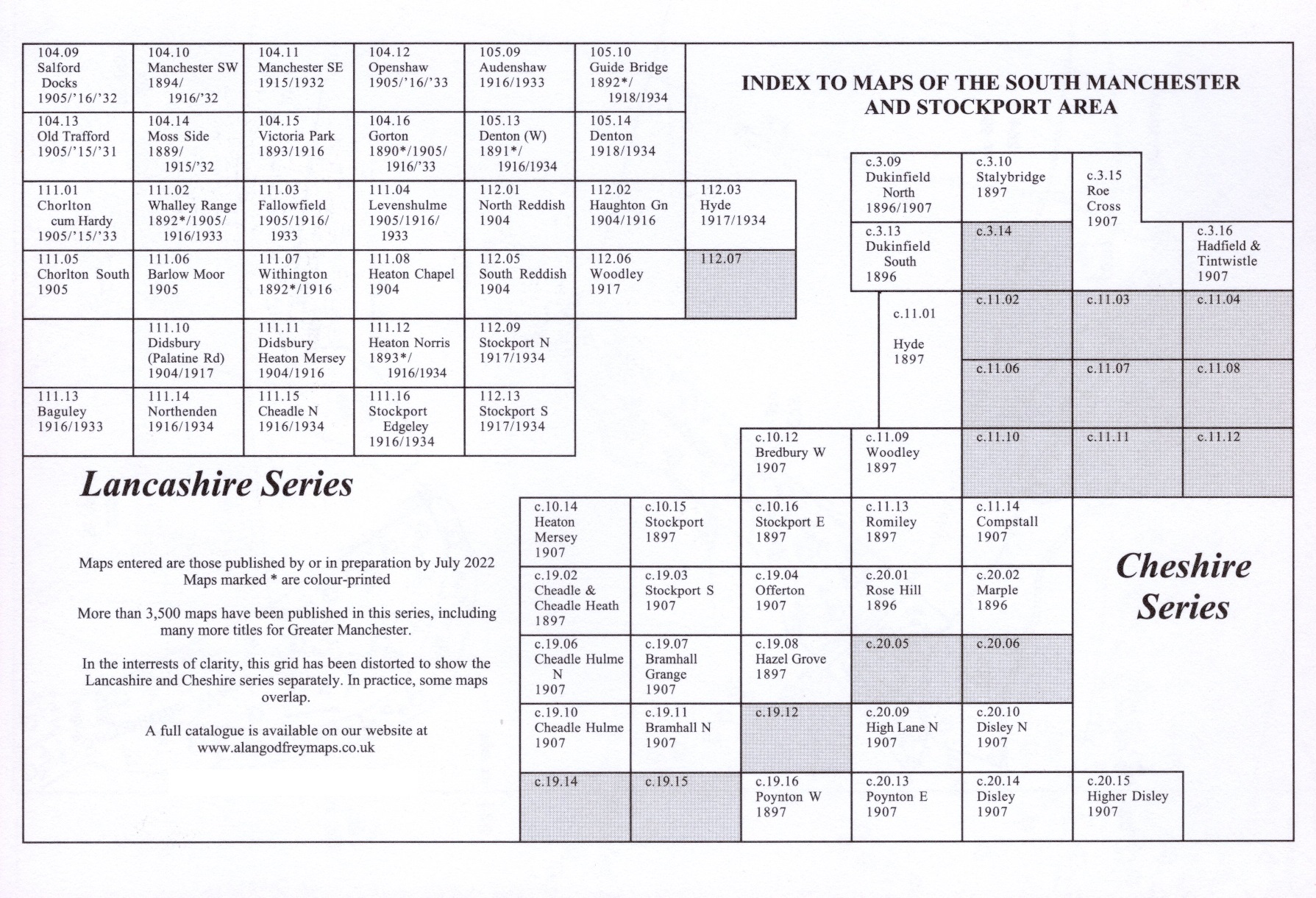
Here is an Index Map to our Stockport maps.
We also publish a series of smaller scale Inch to the Mile maps. Much of the area is covered by the following maps:
98 Stockport, Altrincham & NE Cheshire 1912 - published 2003; intro by Chris Makepeace
For details of this series visit the One Inch page.
 Most maps in the Godfrey Edition are taken from the 25 inch to the mile map and reduced to about 15 inches to the mile.
For a full list of English maps, return to the England page
All maps are available from our On-line Mapshop. Here are the shop links to the Lancashire series maps or
the Cheshire series maps.
Most maps in the Godfrey Edition are taken from the 25 inch to the mile map and reduced to about 15 inches to the mile.
For a full list of English maps, return to the England page
All maps are available from our On-line Mapshop. Here are the shop links to the Lancashire series maps or
the Cheshire series maps.
Alan Godfrey Maps, Prospect Business Park, Leadgate, Consett, DH8 7PW. Tel 01207 583388
The Godfrey Edition / sales@alangodfreymaps.co.uk / 30 May 2025