Old Ordnance Survey Maps of Gateshead
This is our coverage of Gateshead MBC. The Metropolitan Borough of Gateshead was formed in 1974 with the amalgamation of
the County Borough of Gateshead, Blaydon Urban District, Felling Urban District, Whickham Urban District, Ryton Urban District plus a smaller part of Chester-le-Street Rural District.
The following titles are all taken from the OS 25" maps and reduced to a scale of approximately 14 inches to the mile. Each map includes an introduction.
For a summary of Durham's local government history visit This Page.
All maps are available from our On-line Mapshop. They are very detailed and each includes an introduction.
 These are the Gateshead maps in our Tyneside series:
Sheet 17a Elswick & Dunston Riverside 1894 - published 1982, 2nd Edition 2008; intro by Roy Young
Sheet 17b Elswick & Dunston Riverside 1913 - published 1989; intro by Jimmy Donald
Sheet 17c Elswick, New Benwell & Dunston Riverside 1937 - published 2019; intro by Alan Godfrey
Sheet 18a Newcastle & Gateshead 1894 - published 1981, 2nd Edition 1983, 3rd Edition 1987; intro by Alan Godfrey
Sheet 18b Newcastle & Gateshead 1914 - published 1985, 2nd Edition 2002; intro by John Griffiths
Sheet 18c Newcastle & Gateshead 1940 - published 2015; intro by Anthea Lang
Sheet 19a Gateshead (East) 1895 - published 1981, 2nd Edition 1990; intro by Iain Watson
Sheet 19b Gateshead (East) 1913 - published 2014; intro by Anthea Lang
Sheet 19A.2 St Anthony's & Bill Quay 1912 - published 1985; intro by Alan Godfrey
Sheet 19A.3 St Anthony's & Bill Quay 1941 - published 2016; intro by Anthea Lang
Sheet 22a Dunston 1894 - published 1981, rev 1982, 2nd Edition 1992; intro by Andrew Maslivec
Sheet 22b Dunston 1914 - published 2017; intro by Anthea Lang
Sheet 23a Gateshead South (Bensham, Teams & Shipcote) 1894 - published 1981, 3rd Edition 2014; intro by Alan Godfrey
Sheet 23b Gateshead South (Bensham, Teams & Shipcote) 1914 - published 2015; intro by Anthea Lang
Sheet 24a Felling 1894 - published 1982, 2nd Ed 1989, 3rd Ed 2023; intro by Anthea Lang
Sheet 24b Felling 1914 - published 2015; intro by Anthea Lang
Sheet 26a Scotswood & Derwenthaugh 1895 - published 1983, 3rd ed 2009; intro by Roy Young (Map formerly Durham Sheet 2.14)
Sheet 26b Scotswood & Derwenthaugh 1914 - published 2018; intro by Anthea Lang
Sheet 26c Scotswood & Derwenthaugh 1937 - published 2019; intro by Alan Godfrey
Sheet 27a Whickham & Swalwell 1895 - published 1982, 2nd Edition 1996; intro by Robert Forsythe
Sheet 27b Whickham & Swalwell 1914 - published 2017; intro by Anthea Lang
Sheet 27c Whickham & Swalwell 1940 - published 2018; intro by Alan Godfrey
Sheet 28a Blaydon & Stella 1895 - published 1983, 2nd Edition 2003; intro by John Griffiths
Sheet 28b Blaydon & Stella 1914 - published 2018; intro by Anthea Lang
These are the Gateshead maps in our Co Durham series: The two series do link up with each other.
Sheet 01.11 Wylam & Clara Vale 1895 - published 1999; intro by John Griffiths
Sheet 01.12 Ryton 1895 - published 1983, 2nd Edition 2013; intro by Anthea Lang
Sheet 05.11 Chopwell 1915 - published 2018; intro by Neil Gander
Sheet 05.15 Blackhall Mill & Hamsterley Colliery 1915 - published 2018; intro by Anthea Lang
Sheet 06.07 Lobley Hill & Low Streetgate 1895 - published 2017; intro by Anthea Lang
Sheet 06.08a Low Fell 1895 - published 1982, 2nd Edition 2003; intro by John Griffiths
Sheet 06.08b Low Fell 1914 - published 2015; intro by Anthea Lang
Sheet 06.09 Rowlands Gill 1895 - published 2000; intro by Jennifer Gill
Sheet 06.14 Old Marley Hill 1895 - published 2017; intro by Alan Godfrey
Sheet 07.02 Heworth, Pelaw & Wardley 1895 - published 1984, 2nd Edition 2013; intro by Alan Godfrey
Sheet 07.05a Gateshead Fell & Sheriff Hill 1895 - published 1982 (as Sheriff Hill), 2nd Edition 2003; intro by John Griffiths
Sheet 07.05b Gateshead Fell 1914 - published 2021; intro by Anthea Lang
Sheet 07.09 Wrekenton & Eighton Banks 1895 - published 1983, 2nd Edition 2013; intro by Anthea Lang
Sheet 07.13 Birtley (North) 1940 - published 2014; intro by Anthea Lang
Sheet 13.01 Birtley 1895 - published 1982, 2nd Edition 2013; intro by Alan Godfrey
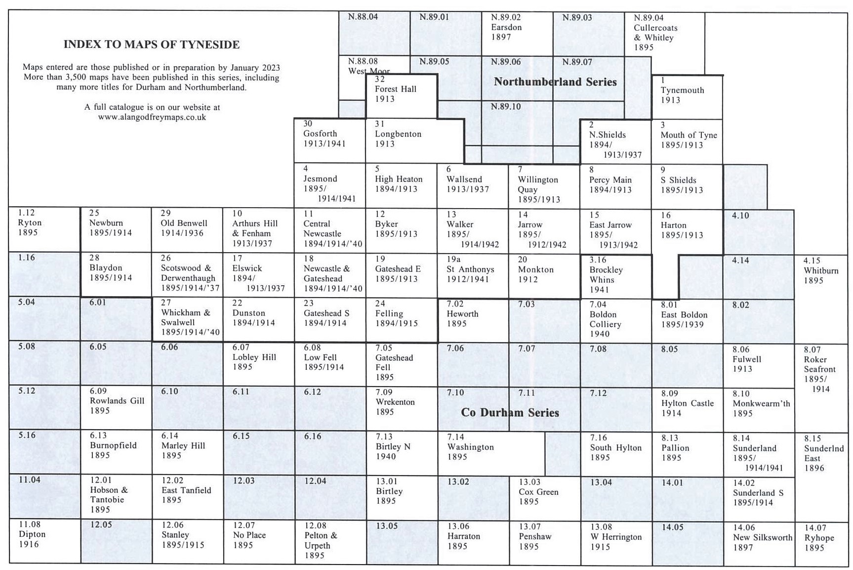
Here is an Index Map for our Tyneside maps.
 Most maps in the Godfrey Edition are taken from the 25 inch to the mile map and reduced to about 15 inches to the mile.
For a full list of English maps, return to the England page
You can order maps direct from our On-line Mapshop.
This list shows all our maps for the area. We try to keep a full range in print but inevitably some titles fall out of print from time to time.
These are noted in our On-line Mapshop.
Most maps in the Godfrey Edition are taken from the 25 inch to the mile map and reduced to about 15 inches to the mile.
For a full list of English maps, return to the England page
You can order maps direct from our On-line Mapshop.
This list shows all our maps for the area. We try to keep a full range in print but inevitably some titles fall out of print from time to time.
These are noted in our On-line Mapshop.
Alan Godfrey Maps, Prospect Business Park, Leadgate, Consett, DH8 7PW. Tel 01207 583388
The Godfrey Edition / sales@alangodfreymaps.co.uk / 28 April 2023