 Here are the details of maps for north Birtley:

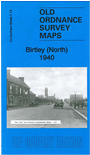
This very detailed map covers the northern part of Birtley.
Features include Bowes Railway, Pelaw Main Wagonway, Vale Pit (disused), North Side, Dunkirk, Longbank Quarry, Elizabethville area, Eighton Lodge, Long Acre, etc. On the reverse we include a section of the earlier1895 map, before Elizabethville was developed.
The map links up with Co Durham 7.09 Wrekenton to the north, 7.14 Washington to the east and 13.01 Birtley to the south.
Maps in the Godfrey Edition are taken from the 25 inch to the mile map and reduced to about 15 inches to the mile. For a full list of maps for England, return to the England page.
Alan Godfrey Maps, Prospect Business Park, Leadgate, Consett, Co Durham, DH8 7PW / sales@alangodfreymaps.co.uk / 14 January 2018