Old Ordnance Survey Maps of Cumberland
We have a range of detailed maps for Cumberland towns and we also cover the whole county at the Inch to the Mile scale. Here are the details.
All maps are available from our On-line Mapshop.
Cumberland County Council governed from 1889-1974. Since 1974 the county has been part of Cumbria. See This page for a summary of its local government history.
The following maps are all taken from the OS 25" maps and reduced to a scale of approximately 15 inches to the mile.
They are extremely detailed, showing individual houses, details such as railway tracks, pathways,
pubs, factories and even minutiae such as fountains and signal posts. Each map includes an introduction.
 These are the maps we publish for towns in Cumberland:
18.05 Brampton 1924 - published 2005; intro by Alan Godfrey
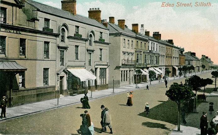
20.11 Silloth & Port Carlisle 1923 - published 2007; intro by Alan Godfrey
23.03 Carlisle NW 1924 - published 1990; intro by Dennis Perriam
23.04 Carlisle NE 1924 - published 1990; intro by Robert Bell
23.07 Carlisle SW 1924 - published 1990; intro by Dennis Perriam
23.08 Carlisle SE 1924 - published 1990; intro by Robert Bell
29.05 Wigton 1924 - published 2014; intro by Alan Godfrey
34.09 Alston 1898 - published 2005; intro by Alan Godfrey
34.15 Nenthead 1898 - published 2007; intro by Alan Godfrey
44.08a Maryport 1899 - published 1990; intro by Stephen White
44.08b Maryport 1922 - published 2022; intro by Sarah Lee
45.05 Maryport East 1923 - published 2022; intro by Sarah Lee
53.07 Workington North 1923 - published 1991; intro by Anne Dick
53.11 Workington South 1923 - published 1991; intro by Anne Dick
54.04a Cockermouth 1898 - published 1991; intro by Alan Godfrey
54.04b Cockermouth 1923 - published 2022; intro by Sarah Lee
58.04a Penrith 1923 - published 2015; intro by Alan Godfrey
58.04b Penrith 1923 - published 1990; intro by John Hurst
64.06a Keswick 1898 - published 1990; intro by Mike Greatbatch
64.06b Keswick 1923 - published 2022; intro by Sarah Lee
67.02 Whitehaven 1923 - published 1990; intro by Anne Dick
67.06 Whitehaven (South) 1923 published 1990; intro by Anne Dick
67.12 Cleator Moor 1923 - published 2022; intro by Barrie Trinder
72.08 Egremont 1923 - published 2022; intro by Barrie Trinder
90.03 Millom 1897 - published 2022; intro by Barrie Trinder
We also cover the area in our Inch to the Mile series. Here are the principal sheets:
11/12 Longtown, Bewcastle & District 1902- publication 2004; intro by John Griffiths. Includes a
detailed map of Longtown itself.
16/22 Maryport & Silloth 1903- published 2007; intro by Paul Hindle. Includes a map of Risehow.
17 Carlisle & The Solway Firth 1895 - published 2008; intro by Barrie Trinder. Includes a map of Kirkbride.
18 Brampton & District 1903 - published 2008; intro by Barrie Trinder. Includes a map of Wetheral.
23 Caldbeck, Wigton & the Northern Fells 1903 - published 2004; intro by Paul Hindle. Includes a map of Aspatria.
24 Penrith, Inglewood & Hartside 1903 - published 2002, 2nd Edition 2013; intro by Neil Gander. Includes a map of Kirkoswald.
25 Alston Moor & Upper Weardale 1903 - published 2001; intro by Robert Forsythe. Includes a map of Bolt's Burn, Rookhope.
28 Whitehaven & Workington 1903-14- published 2007; intro by Paul Hindle. Includes a map of St Bees
29 Keswick & the Northern Lake District 1903- published 2007; intro by Paul Hindle. Includes a map of Buttermere.
37/47 Ravenglass & Sellafield 1875- published 2008; intro by Alan Godfrey. Includes a map of Gosforth.
38 Coniston & Ambleside 1895 - published 2011; intro by Derrick Pratt. Includes a map of Coniston.
48 North Furness 1896 - published 2002; intro by Alan Crosby. Includes a map of Cartmel.
For further details visit the One Inch page.
 Most maps in the Godfrey Edition are taken from the 25 inch to the mile map and reduced to about 15 inches to the mile.
For a full list of English maps, return to the England page
You can order maps direct from our On-line Mapshop.
Most maps in the Godfrey Edition are taken from the 25 inch to the mile map and reduced to about 15 inches to the mile.
For a full list of English maps, return to the England page
You can order maps direct from our On-line Mapshop.
This list shows all our maps for the county. We try to keep a full range in print but inevitably some titles fall out of print from time to time.
These are noted in our On-line Mapshop.
Alan Godfrey Maps, Prospect Business Park, Leadgate, Consett, DH8 7PW. Tel 01207 583388
The Godfrey Edition / sales@alangodfreymaps.co.uk / 19 August 2022
 These are the maps we publish for towns in Cumberland: