Old Ordnance Survey Maps of Cheshire
This is our coverage of Cheshire, historically the County Palatine of Chester. In 1974 the county was divided into eight administrative districts, Chester, Congleton,
Crewe & Nantwich, Ellesmere Port & Neston, Halton, Macclesfield, Vale Royal and Warrington. In 1998 Halton and Warrington became unitary authorities.
In 2009 the remainder of the county was divided into two unitary authorities, Chester West & Chester, which included Chester, Ellesmere Port &
Neston, and Vale Royal; and Cheshire East, which included Congleton, Crewe & Nantwich, and Macclesfield. This page lists all the Cheshire maps in these districts.
See separate pages for the Cheshire maps in Stockport, Tameside and
Trafford, which became part of Greater Manchester in 1974, and Wirral, which became
part of Merseyside. These all remain unitary auhorities.
All maps are available from our On-line Mapshop.
The following titles are all taken from the OS 25" maps and reduced to a scale of approximately 14 inches to the mile.
They are extremely detailed, showing individual houses, details such as railway tracks, pathways,
pubs, factories and even minutiae such as fountains and signal posts. Each covers an area of a mile and a half by one mile, and includes an introduction.
These are the maps for Cheshire:
17.05 Thelwall 1908 - published 2003; intro by Chris E Makepeace
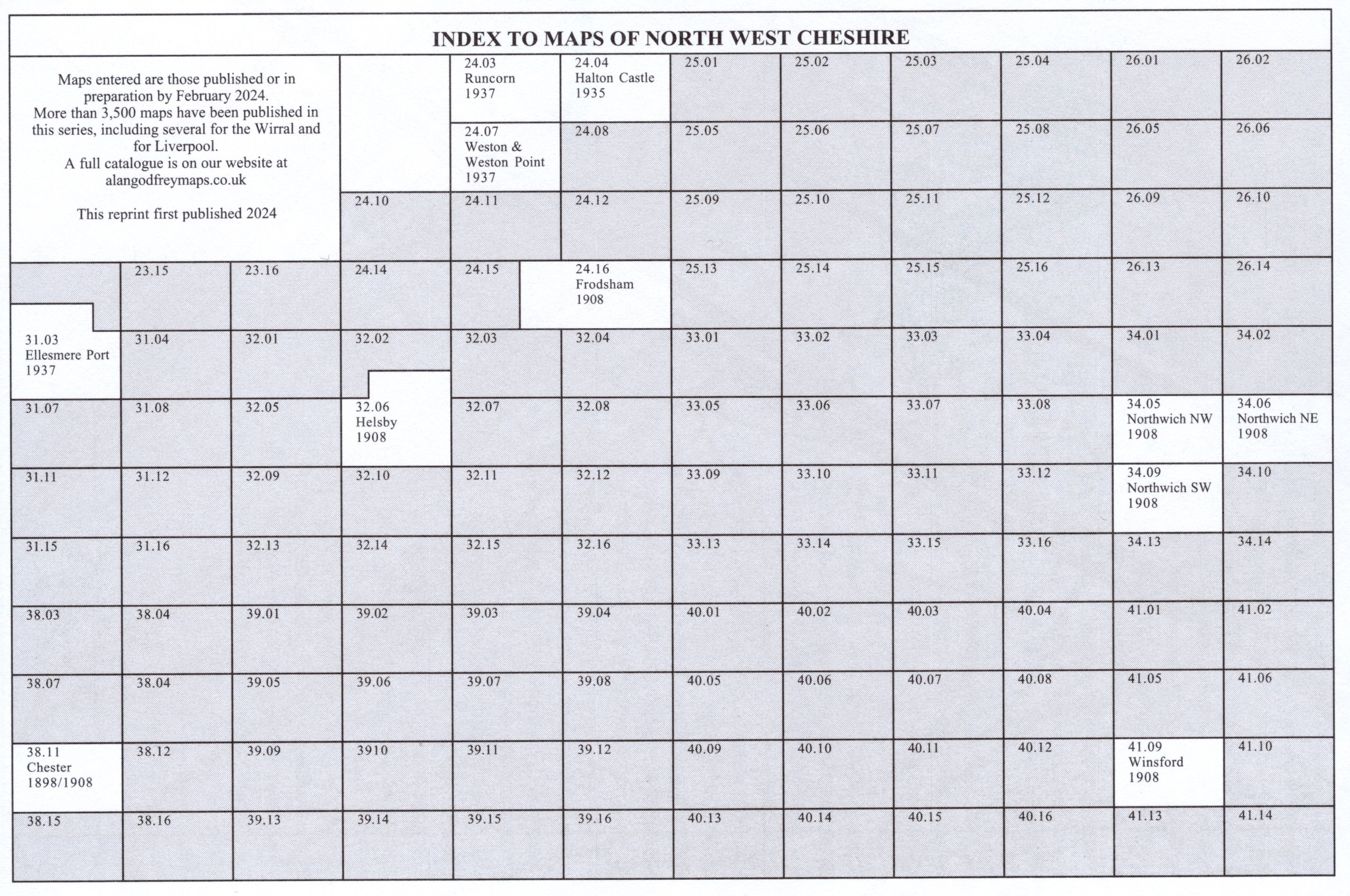
24.03 Runcorn 1937 - published 2023; intro by Alan Godfrey
24.04 Halton Castle & East Runcorn 1935 - published 2023; intro by Alan Godfrey
24.07 Weston & Weston Point 1937 - published 2024; intro by Alan Godfrey
24.16 Frodsham 1908 - published 2023; intro by Alan Godfrey
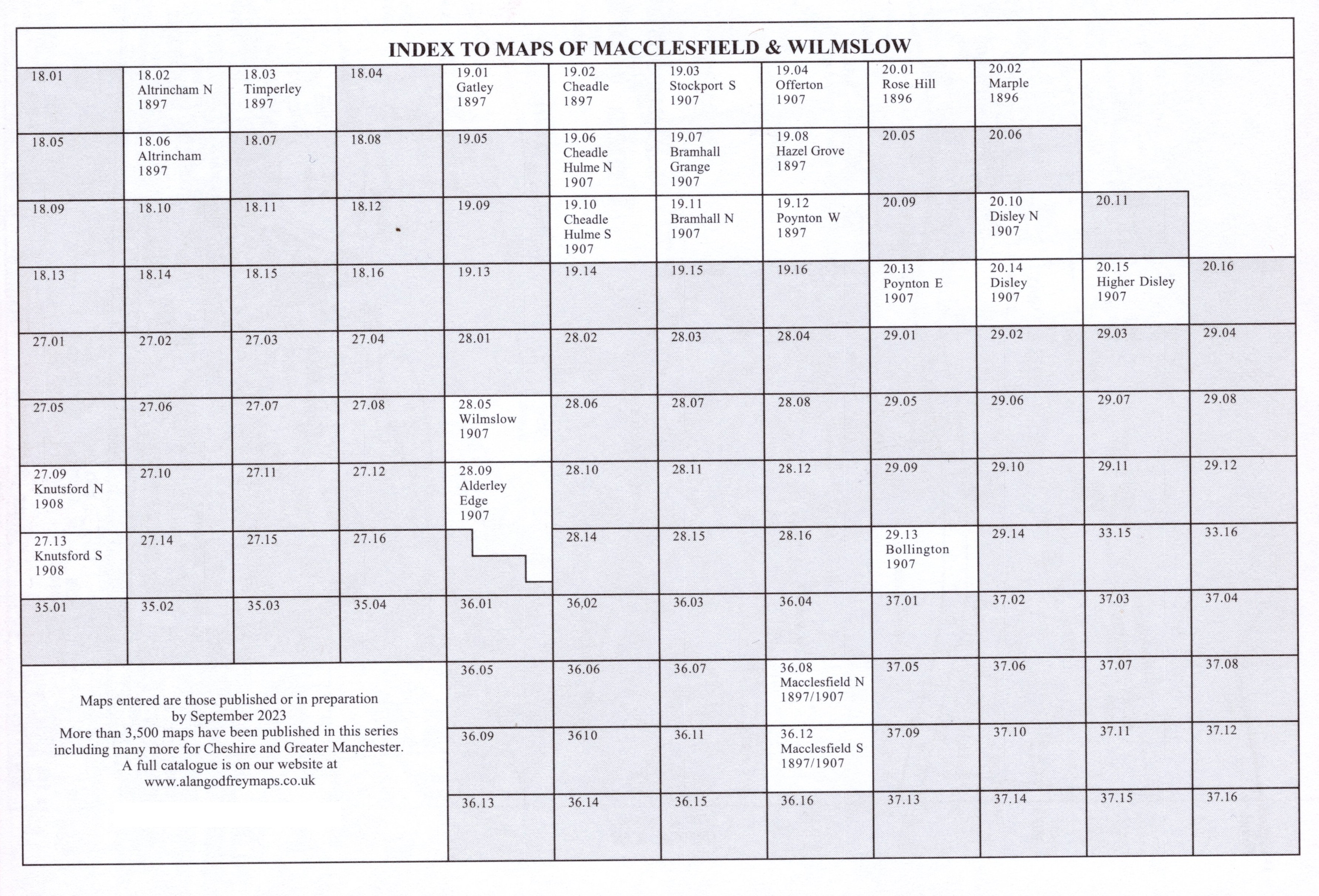
27.09 Knutsford (North) 1908 - published 2005; intro by Derrick Pratt
27.13 Knutsford (South) 1908 - published 2004; intro by Derrick Pratt
28.05 Wilmslow 1907 - published 2023; intro by Chris E Makepeace
28.09 Alderley Edge 1907 - published 2023; intro by Chris E Makepeace
29.13 Bollington 1907 - published 2005; intro by Chris E Makepeace
31.03 Ellesmere Port 1937 - published 2024; intro by Kay Parrott
32.06 Helsby 1908 - published 2023; intro by Alan Godfrey
34.05 Northwich NW & Winnington 1908 - publ 2004; intro by Derrick Pratt
34.06 Northwich NE 1908 - publ 2004; intro by Derrick Pratt
34.09 Northwich SW 1908 - publ 2004; intro by Derrick Pratt
36.08a Macclesfield (North) 1897 - publ 2023; intro by Chris E Makepeace
36.08b Macclesfield (North) 1907 - publ 2001; intro by Chris E Makepeace
36.12a Macclesfield (South) 1897 - publ 1998; intro by Chris E Makepeace
36.12b Macclesfield (South) 1907 - publ 2023; intro by Chris E Makepeace
38.11a Chester 1898 - publ 1989; intro by Simon Harrison
38.11b Chester 1908 - publ 2004; intro by Derrick Pratt
41.09 Winsford 1908 - publ 2007; intro by Derrick Pratt
41.11 Middlewich 1908 - publ 2010; intro by Derrick Pratt
51.02 Congleton 1897 - publ 2011; intro by Derrick Pratt
56.07a Crewe 1874 - publ 2011; intro by Derrick Pratt
56.07b Crewe 1908 - publ 1994; intro by Alan Godfrey
56.08 Crewe (East) 1908 - publ 1994; intro by Alan Godfrey
56.13 Nantwich 1908 - publ 2002; intro by Alan Crosby
57.07 Alsager 1908 - publ 2004; intro by Malcolm Nixon
Here are index grids for North West Cheshire and North East Cheshire.
We also publish a series of smaller scale Inch to the Mile maps, and all of Cheshire is covered. The main maps for the county are:
096 Liverpool & The Wirral 1904 includes a map of Wirral Colliery
097 The Lower Mersey, Runcorn & Warrington 1913 includes a map of Preston Brook
098 Stockport, Altrincham & NE Cheshire 1912 includes a map of Adlington Hall
109 Chester & Central Cheshire 1905 includes a map of Tattenhall
110 Macclesfield, Congleton & District 1898 includes a map of Elworth
122 Whitchurch, Nantwich & English Maelor 1905 includes a map of Holt & Farndon
For full details of this series visit the One Inch page.
 Most maps in the Godfrey Edition are taken from the 25 inch to the mile map and reduced to about 15 inches to the mile.
For a full list of English maps, return to the England page
We do try to keep maps in print wherever possible, but inevitably some fall out of print from to time. These are all noted on our
On-line Mapshop.
Most maps in the Godfrey Edition are taken from the 25 inch to the mile map and reduced to about 15 inches to the mile.
For a full list of English maps, return to the England page
We do try to keep maps in print wherever possible, but inevitably some fall out of print from to time. These are all noted on our
On-line Mapshop.
Alan Godfrey Maps, Prospect Business Park, Leadgate, Consett, DH8 7PW. Tel 01207 583388
The Godfrey Edition / sales@alangodfreymaps.co.uk / 4 April 2024