
Old Ordnance Survey Maps of the Wirral
This is our coverage of Wirral. The Metropolitan Borough of Wirral was formed in 1974 with the amalgamation
of the County Borough of Birkenhead, County Borough of Wallasey, Municipal Borough of Bebington, Hoylake Urban District and Wirral Urban District. At
the same time it became part of the new Metropolitan County of Merseyside.
All maps are available from our On-line Mapshop.
The following titles are all taken from the OS 25" maps and reduced to a scale of approximately 14 inches to the mile.
Each covers an area of a mile and a half by one mile, and includes an introduction.
These are our maps for Wirral:
07.07a New Brighton 1909 - published 1989; introduction by Carol Bidston
07.07b New Brighton 1935 - published 2008; introduction by Derrick Pratt
07.10a Wallasey Village 1898 - published 1990; intro by Carol Bidston
07.10b Wallasey Village 1909 - published 2018; intro by Kay Parrott
07.11a Liscard & Egremont 1898 - published 1988; intro by Carol Bidston
07.11b Liscard & Egremont 1909 - published 2018; intro by Kay Parrott
07.14 Bidston 1898 - published 1991; intro by Carol Bidston
07.15 Poulton cum Seacombe 1909 - published 1989; intro by Carol Bidston
12.03 Hoylake 1909 - published 1991; intro by David Thompson
12.07 Hoylake cum Kirby 1909 - published 1991; intro by David Thompson. This also includes
a map of Hilbre Island.
12.11 West Kirby 1909 - published 1991; intro by David Thompson.
13.02 Bidston Hill 1909 - published 1991; intro by Carol Bidston
13.03a Birkenhead 1899 - published 2018; intro by Kay Parrott
13.03b Birkenhead 1909 - published 1988, 2nd Edition 2019; intro by David Thompson & Kay Parrott
13.04 Birkenhead & Tranmere Waterfront 1909 - published 2019; intro by Kay Parrott
13.07 Tranmere & Oxton 1909 - published 1989; intro by David Thompson
13.12 Rock Ferry & New Ferry - published 1990; intro by David Thompson
13.16 Port Sunlight & Bebington 1897 - published 1990; intro by David Thompson
22.14 Neston & Parkgate 1909 - published 2004; intro by Kay Parrott
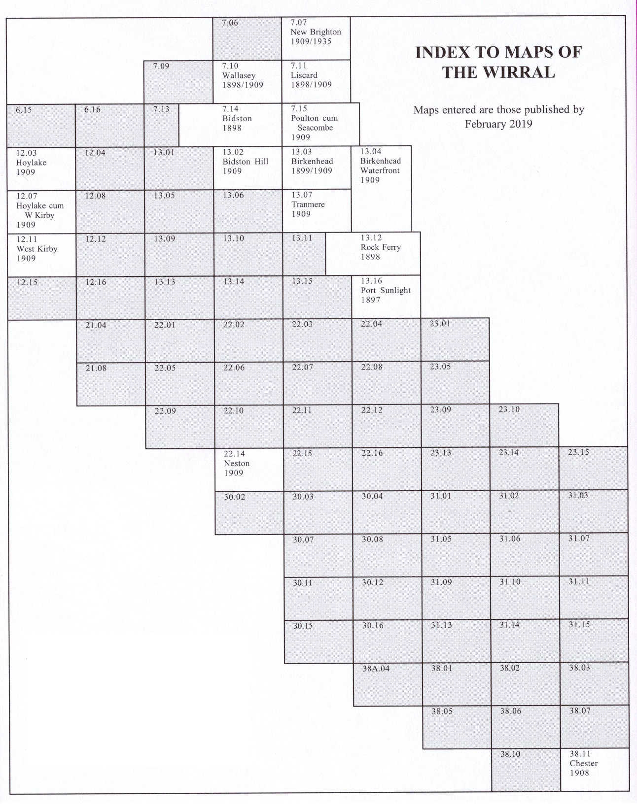
Here is an Index Map to our maps of the Wirral.
We also publish a series of smaller scale Inch to the Mile maps. The Wirral is covered by the following map:
96 Liverpool & The Wirral 1904 - published 2003; intro by Derrick Pratt
For details of this series visit the One Inch page.
 Most maps in the Godfrey Edition are taken from the 25 inch to the mile map and reduced to about 15 inches to the mile.
For a full list of North West maps, return to the North West page
Most maps in the Godfrey Edition are taken from the 25 inch to the mile map and reduced to about 15 inches to the mile.
For a full list of North West maps, return to the North West page
Alan Godfrey Maps, Prospect Business Park, Leadgate, Consett, DH8 7PW. Tel 01207 583388
The Godfrey Edition / sales@alangodfreymaps.co.uk / 8 September 2022