
Old Ordnance Survey Maps of Sunderland
This is our coverage of the City of Sunderland. The Metropolitan Borough of Sunderland was formed in 1974 with the amalgamation of
the County Borough of Sunderland, Hetton Urban District, Houghton-le-Spring Urban District, Washington Urban District plus smaller parts of Chester-le-Street Rural District and Easington Rural District. It was granted city status in 1992.
All maps are available from our On-line Mapshop.
The following titles are all taken from the OS 25" maps and reduced to a scale of approximately 14 inches to the mile. Each includes an introduction.
 These are the maps we publish for Sunderland:
07.10 Springwell & Great Usworth 1895 - published 2026; intro by Anthea Lang
07.14 Washington 1896 - published 1997; intro by David Butler
07.16 South Hylton 1895 - published 2014; intro by Alan Godfrey
08.01a East Boldon 1895 - published 2006; intro by David Butler
08.01b East Boldon 1939 - published 2023; intro by Anthea Lang
08.06 Sunderland (Fulwell) 1913 - published 2020; intro by Alan Godfrey
08.07a Roker Seafront 1895 - published 2023; intro by Alan Godfrey
08.07b Roker Seafront 1914 - published 2018; intro by Anthea Lang
08.09 Hylton Castle & Castletown 1914 - published 2020; intro by Alan Godfrey
08.10a Monkwearmouth & Southwick 1895 - published 1983, 2nd edition 2019; intro by Tom Corfe & Alan Godfrey
08.10b Monkwearmouth & Southwick 1914 - published 2026; intro by John Griffiths
08.13 Sunderland (Pallion) 1895 - published 2006; intro by John Griffiths
08.14a Central Sunderland 1895 - published 1982, 2nd Edition 2001; intro by John Griffiths
08.14b Central Sunderland 1914 - published 2016; intro by Alan Godfrey
08.14c Central Sunderland 1941 - published 2023; intro by David & Helene Farn
08.15 Sunderland (East) 1895 - published 1983, 2nd Edition 2014; intro by Alan Godfrey
13.03 Cox Green & Washington Station 1895 - published 2016; intro by Alan Godfrey
13.06 Harraton & Fatfield 1895 - published 2017; intro by Alan Godfrey
13.07 Penshaw 1895 - published 2016; intro by Alan Godfrey
13.08 West Herrington 1915 - published 2023; intro by Alan Godfrey
13.12 Newbottle, Philadelphia & New Herrington 1895 - published 2017; intro by Alan Godfrey
13.15 Fencehouses & New Lambton 1895 - published 2016; intro by Alan Godfrey
13.16a Houghton-le-Spring 1856 - published 2022; intro by Alan Godfrey  13.16b Houghton-le-Spring 1895 - published 2001; intro by John Griffiths
14.02a Sunderland (South) 1895 - published 1982, 2nd Edition 2006; intro by David Butler
14.02b Sunderland (South) 1914 - published 2022; intro by David & Helene Farn
14.06 New Silksworth, Tunstall & Ryhope Colliery 1895 - published 2020; intro by Alan Godfrey
14.07 Ryhope Village 1895 - published 2009; intro by Alan Godfrey
20.04 Hetton Downs & Rainton Bridge 1895 - published 2006; intro by David Butler.
20.08 Hetton-le-Hole & East Rainton 1895 - published 2007; intro by David Butler.
21.03 Seaham Harbour 1895 - published 1984, 2nd Edition 2010; intro by Alan Godfrey
13.16b Houghton-le-Spring 1895 - published 2001; intro by John Griffiths
14.02a Sunderland (South) 1895 - published 1982, 2nd Edition 2006; intro by David Butler
14.02b Sunderland (South) 1914 - published 2022; intro by David & Helene Farn
14.06 New Silksworth, Tunstall & Ryhope Colliery 1895 - published 2020; intro by Alan Godfrey
14.07 Ryhope Village 1895 - published 2009; intro by Alan Godfrey
20.04 Hetton Downs & Rainton Bridge 1895 - published 2006; intro by David Butler.
20.08 Hetton-le-Hole & East Rainton 1895 - published 2007; intro by David Butler.
21.03 Seaham Harbour 1895 - published 1984, 2nd Edition 2010; intro by Alan Godfrey
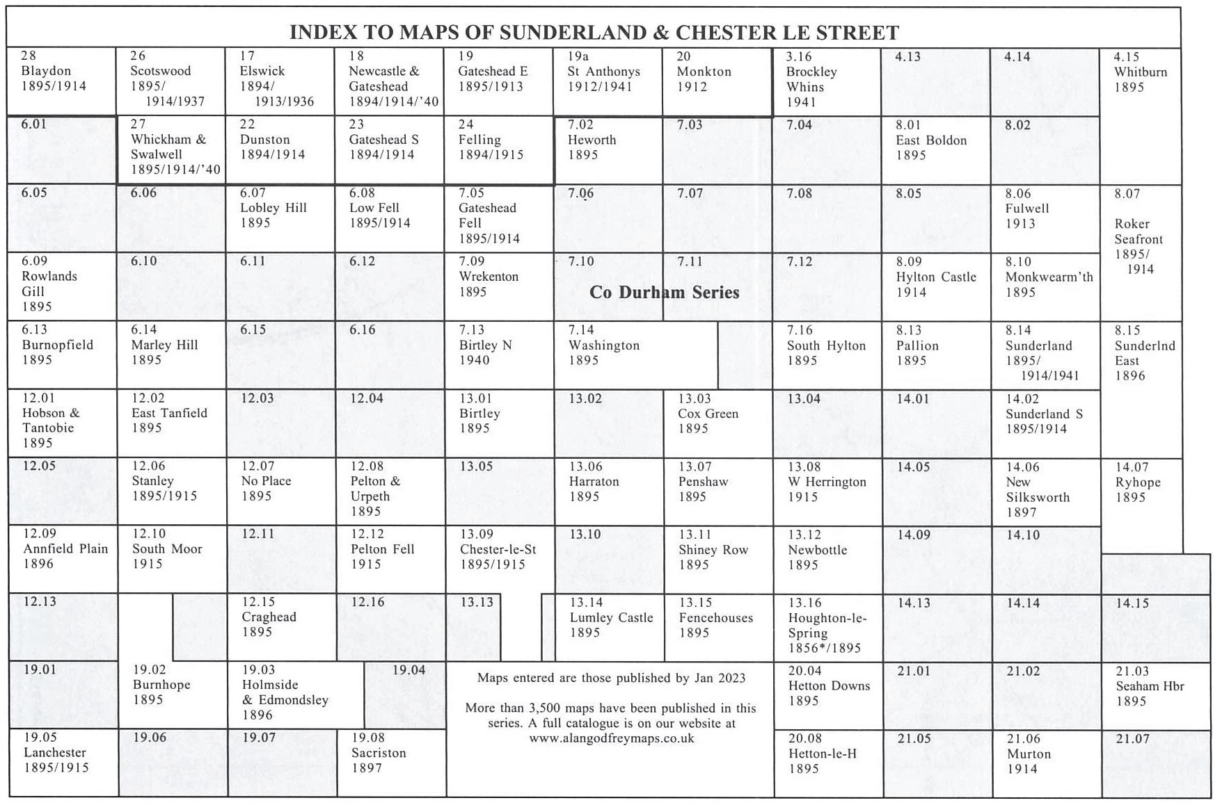
Here is an Index Map to our Sunderland maps.
Also in the Godfrey Edition, some of our One Inch to the Mile maps cover the Sunderland area:
.15/21 Tynemouth, Sunderland & the NE Coalfield 1895 includes a map of Whitburn
.20/21 Tyneside & Wearside 1878
.27 Hartlepool & East Durham 1913 with a map of Trimdon village
Go to the One Inch page for further details of this series.
 Most maps in the Godfrey Edition are taken from the 25 inch to the mile map and reduced to about 15 inches to the mile.
For a full list of English maps, return to the England page
Most maps in the Godfrey Edition are taken from the 25 inch to the mile map and reduced to about 15 inches to the mile.
For a full list of English maps, return to the England page
Alan Godfrey Maps, Prospect Business Park, Leadgate, Consett, DH8 7PW. Tel 01207 583388
The Godfrey Edition / sales@alangodfreymaps.co.uk / 28 May 2026