
Old Ordnance Survey Maps of Leeds
This is our coverage of the City of Leeds. This is a metropolitan district formed in 1974 with the amalgamation of the County Borough of Leeds
with Morley Municipal Borough, Pudsey Municipal Borough, Aireborough Urban District, Garforth Urban District, Horsforth Urban District, Otley Urban District, Rothwell Urban District, plus some outlying parishes. It
is a unitary authority with city and borough status.
All maps are available from our On-line Mapshop.
 The following maps for Leeds are taken from the OS 25" maps and reduced to a scale of approximately 14 inches to the mile.
They are extremely detailed, showing individual houses, details such as railway tracks, pathways,
pubs, factories and even minutiae such as fountains and signal posts. Each covers an area of a mile and a half by one mile, and includes an introduction.
The following maps for Leeds are taken from the OS 25" maps and reduced to a scale of approximately 14 inches to the mile.
They are extremely detailed, showing individual houses, details such as railway tracks, pathways,
pubs, factories and even minutiae such as fountains and signal posts. Each covers an area of a mile and a half by one mile, and includes an introduction.
172.14 Wetherby 1907 - published 2020; intro by Alan Godfrey
187.06 Otley 1906 - published 2004; introduction by Suzanne Grahame
187.12 Bramhope 1906 - published 2022; intro by Alan Godfrey
187.13 Guiseley 1906 - published 2002; intro by Alan Godfrey
189.07 Boston Spa & Thorp Arch 1906 - published 2021; intro by Alan Godfrey
202.02 Yeadon 1906 - published 2002; intro by Suzanne Grahame
202.05 Apperley Bridge & Thackley 1906 - published 2025; intro by Martin Handley
202.06 Rawdon 1906 - published 2012; intro by Ruth Strong
202.07 Horsforth (North) 1906 - published 2024; intro by Martin Handley
202.10 Calverley 1915 - published 2009; intro by Ruth Strong
202.11a Horsforth 1906 - published 1995; intro by G C Dickinson
202.11b Horsforth 1934 - published 2024; intro by Martin Handley
202.12 Horsforth Woodside & West Park 1906 - published 1995; intro by G C Dickinson
202.13 Eccleshill 1892 - published 2010; intro by Ruth Strong
202.14 Farsley 1915 - published 2008; intro by Ruth Strong
202.15a Bramley (North) & Rodley 1906 - published 2007; intro by Suzanne Grahame
202.15b Bramley (North) & Rodley 1934 - published 2010; intro by Ruth Strong
202.16 Kirkstall 1906 - published 1994; intro by G C Dickinson
203.07 Shadwell & North Roundhay 1906 - published 2023; intro by Martin Handley
203.09a Meanwood & Far Headingley 1906 - published 1996; intro by G C Dickinson
203.09b Meanwood & Far Headingley 1919 - published 2022; intro by Alan Godfrey
203.10a Chapel Allerton & Gledhow 1906 - published 1996; intro by G C Dickinson
203.10b Chapel Allerton & Gledhow 1919 - published 2021; intro by Alan Godfrey
203.11 Roundhay Park 1906 - published 1996; intro by G C Dickinson
203.13a Headingley 1890 - published 2016; intro by Alan Godfrey  203.13b Headingley 1906 - published 1992; intro by G C Dickinson
203.13c Headingley 1934 - published 2008; intro by G C Dickinson
203.14a Leeds (Harehills, Buslingthorpe & Chapeltown Rd) 1890 - published 2018; intro by Alan Godfrey
203.14b Leeds (Harehills, Buslingthorpe & Chapeltown Rd) 1906 - published 1992; intro by G C Dickinson
203.14c Leeds (Harehills, Buslingthorpe & Chapeltown Rd) 1919 - published 2021; intro by G C Dickinson
203.15 Leeds (Oakwood & Gipton) 1906 - published 2023; intro by Martin Handley
203.16 Seacroft 1906 - published 2022; intro by Martin Handley
204.15 Aberford & Parlington 1906 - published 2021; intro by Alan Godfrey
217.02 Stanningley 1906 - published 2009; intro by Ruth Strong
217.03a Bramley 1906 - published 2001; intro by Alan Godfrey
217.03b Bramley 1933 - published 2010; intro by Ruth Strong
217.04 Upper Armley 1906 - published 2001; intro by Alan Godfrey
217.06a Pudsey (Chapeltown & Fulneck) 1890 - published 2011; intro by Ruth Strong.
217.06b Pudsey (Chapeltown & Fulneck) 1906 - published 2002; intro by G C Dickinson
217.07 Pudsey (East) & Farnley Hall 1906 - published 2009; intro by Ruth Strong
217.08 Wortley & Old Farnley 1906 - published 2002; intro by Alan Godfrey
217.10 Tong 1905 - published 2012; intro by Ruth Strong
217.11 Farnley Moor Top 1906 - published 2015; intro by Ruth Strong
217.12 New Farnley 1906 - published 2016; intro by Ruth Strong
217.14 Drighlington (W) 1905 - published 2013; intro by Ruth Strong
217.15 Gildersome 1905 - published 2014; intro by Ruth Strong
218.01a Leeds (NW) 1889 - published 2011; intro by Alan Godfrey.
218.01b Leeds (NW) 1908 - published 1989; intro by G C Dickinson
218.02a Leeds (NE) 1890 - published 2011; intro by Alan Godfrey
218.02b Central Leeds 1906 - published 1988; intro by G C Dickinson
218.02c Leeds (NE) 1919 - published 2022; intro by Martin Handley
218.03 East Leeds 1906 - published 1998; intro by G C Dickinson
218.04 Cross Gates & Halton (North) 1906 - published 1999; intro by G C Dickinson
218.05a Leeds SW: Holbeck & New Wortley 1888 - published 2011; intro by Alan Godfrey
218.05b Leeds SW: Holbeck & New Wortley 1906 - published 1987; intro by G C Dickinson
218.05c Leeds SW: Holbeck & New Wortley 1915 - published 2024; intro by Alan Godfrey
218.06a Leeds (SE) 1890 - published 2011; intro by Alan Godfrey.
218.06b Leeds (SE) 1906 - published 1989; intro by G C Dickinson
218.06c Leeds (SE) 1919 - published 2022; intro by Alan Godfrey
218.07 Leeds (Osmondthorpe & Neville Hill) 1906 - published 2001; intro by G C Dickinson
218.08 Temple Newsam 1905 - published 2017; intro by Alan Godfrey
218.09 Beeston & Beeston Hill 1905 - published 2002; intro by G C Dickinson
218.10a Hunslet 1890 - published 2014; intro by G C Dickinson
218.10b Hunslet 1905 - published 1995; intro by G C Dickinson
218.11 Thorpe Stapleton 1905 - published 2023; intro by Martin Handley
218.15 Rothwell Haigh 1905 - published 2016; intro by Alan Godfrey
218.16 Woodlesford 1905 - published 2016; intro by Alan Godfrey
219.06 Garforth 1906 - published 2020; intro by Alan Godfrey
219.13 Swillington 1905 - published 2022; intro by Alan Godfrey
219.14 Kippax 1905 - published 2020; intro by Alan Godfrey
232.02 Birkenshaw & Oakwell Hall 1905 - published 2014; intro by Alan Godfrey
232.03 Gildersome Street 1906 - published 2013; intro by Alan Godfrey
232.04a Morley 1891 - published 2013; intro by Alan Godfrey
232.04b Morley 1906 - published 1993; intro by G C Dickinson
232.08 Morley (South) 1906 - published 2013; intro by Alan Godfrey
233.03 Rothwell 1905 - published 2016; intro by Alan Godfrey
233.04 Oulton 1905 - published 2016; intro by Alan Godfrey
233.06 Thorpe on the Hill & Ardsley Station 1906 - published 2024; intro by Martin Handley
233.07 Lofthouse & Ouzelwell Green 1905 - published 2024; intro by Martin Handley
233.10 East Ardsley 1906 - published 2024; intro by Martin Handley
233.11 Lofthouse Gate & Outwood 1913 - published 2021; intro by Alan Godfrey
234.02 Allerton Bywater 1905 - published 2020; intro by Alan Godfrey
203.13b Headingley 1906 - published 1992; intro by G C Dickinson
203.13c Headingley 1934 - published 2008; intro by G C Dickinson
203.14a Leeds (Harehills, Buslingthorpe & Chapeltown Rd) 1890 - published 2018; intro by Alan Godfrey
203.14b Leeds (Harehills, Buslingthorpe & Chapeltown Rd) 1906 - published 1992; intro by G C Dickinson
203.14c Leeds (Harehills, Buslingthorpe & Chapeltown Rd) 1919 - published 2021; intro by G C Dickinson
203.15 Leeds (Oakwood & Gipton) 1906 - published 2023; intro by Martin Handley
203.16 Seacroft 1906 - published 2022; intro by Martin Handley
204.15 Aberford & Parlington 1906 - published 2021; intro by Alan Godfrey
217.02 Stanningley 1906 - published 2009; intro by Ruth Strong
217.03a Bramley 1906 - published 2001; intro by Alan Godfrey
217.03b Bramley 1933 - published 2010; intro by Ruth Strong
217.04 Upper Armley 1906 - published 2001; intro by Alan Godfrey
217.06a Pudsey (Chapeltown & Fulneck) 1890 - published 2011; intro by Ruth Strong.
217.06b Pudsey (Chapeltown & Fulneck) 1906 - published 2002; intro by G C Dickinson
217.07 Pudsey (East) & Farnley Hall 1906 - published 2009; intro by Ruth Strong
217.08 Wortley & Old Farnley 1906 - published 2002; intro by Alan Godfrey
217.10 Tong 1905 - published 2012; intro by Ruth Strong
217.11 Farnley Moor Top 1906 - published 2015; intro by Ruth Strong
217.12 New Farnley 1906 - published 2016; intro by Ruth Strong
217.14 Drighlington (W) 1905 - published 2013; intro by Ruth Strong
217.15 Gildersome 1905 - published 2014; intro by Ruth Strong
218.01a Leeds (NW) 1889 - published 2011; intro by Alan Godfrey.
218.01b Leeds (NW) 1908 - published 1989; intro by G C Dickinson
218.02a Leeds (NE) 1890 - published 2011; intro by Alan Godfrey
218.02b Central Leeds 1906 - published 1988; intro by G C Dickinson
218.02c Leeds (NE) 1919 - published 2022; intro by Martin Handley
218.03 East Leeds 1906 - published 1998; intro by G C Dickinson
218.04 Cross Gates & Halton (North) 1906 - published 1999; intro by G C Dickinson
218.05a Leeds SW: Holbeck & New Wortley 1888 - published 2011; intro by Alan Godfrey
218.05b Leeds SW: Holbeck & New Wortley 1906 - published 1987; intro by G C Dickinson
218.05c Leeds SW: Holbeck & New Wortley 1915 - published 2024; intro by Alan Godfrey
218.06a Leeds (SE) 1890 - published 2011; intro by Alan Godfrey.
218.06b Leeds (SE) 1906 - published 1989; intro by G C Dickinson
218.06c Leeds (SE) 1919 - published 2022; intro by Alan Godfrey
218.07 Leeds (Osmondthorpe & Neville Hill) 1906 - published 2001; intro by G C Dickinson
218.08 Temple Newsam 1905 - published 2017; intro by Alan Godfrey
218.09 Beeston & Beeston Hill 1905 - published 2002; intro by G C Dickinson
218.10a Hunslet 1890 - published 2014; intro by G C Dickinson
218.10b Hunslet 1905 - published 1995; intro by G C Dickinson
218.11 Thorpe Stapleton 1905 - published 2023; intro by Martin Handley
218.15 Rothwell Haigh 1905 - published 2016; intro by Alan Godfrey
218.16 Woodlesford 1905 - published 2016; intro by Alan Godfrey
219.06 Garforth 1906 - published 2020; intro by Alan Godfrey
219.13 Swillington 1905 - published 2022; intro by Alan Godfrey
219.14 Kippax 1905 - published 2020; intro by Alan Godfrey
232.02 Birkenshaw & Oakwell Hall 1905 - published 2014; intro by Alan Godfrey
232.03 Gildersome Street 1906 - published 2013; intro by Alan Godfrey
232.04a Morley 1891 - published 2013; intro by Alan Godfrey
232.04b Morley 1906 - published 1993; intro by G C Dickinson
232.08 Morley (South) 1906 - published 2013; intro by Alan Godfrey
233.03 Rothwell 1905 - published 2016; intro by Alan Godfrey
233.04 Oulton 1905 - published 2016; intro by Alan Godfrey
233.06 Thorpe on the Hill & Ardsley Station 1906 - published 2024; intro by Martin Handley
233.07 Lofthouse & Ouzelwell Green 1905 - published 2024; intro by Martin Handley
233.10 East Ardsley 1906 - published 2024; intro by Martin Handley
233.11 Lofthouse Gate & Outwood 1913 - published 2021; intro by Alan Godfrey
234.02 Allerton Bywater 1905 - published 2020; intro by Alan Godfrey
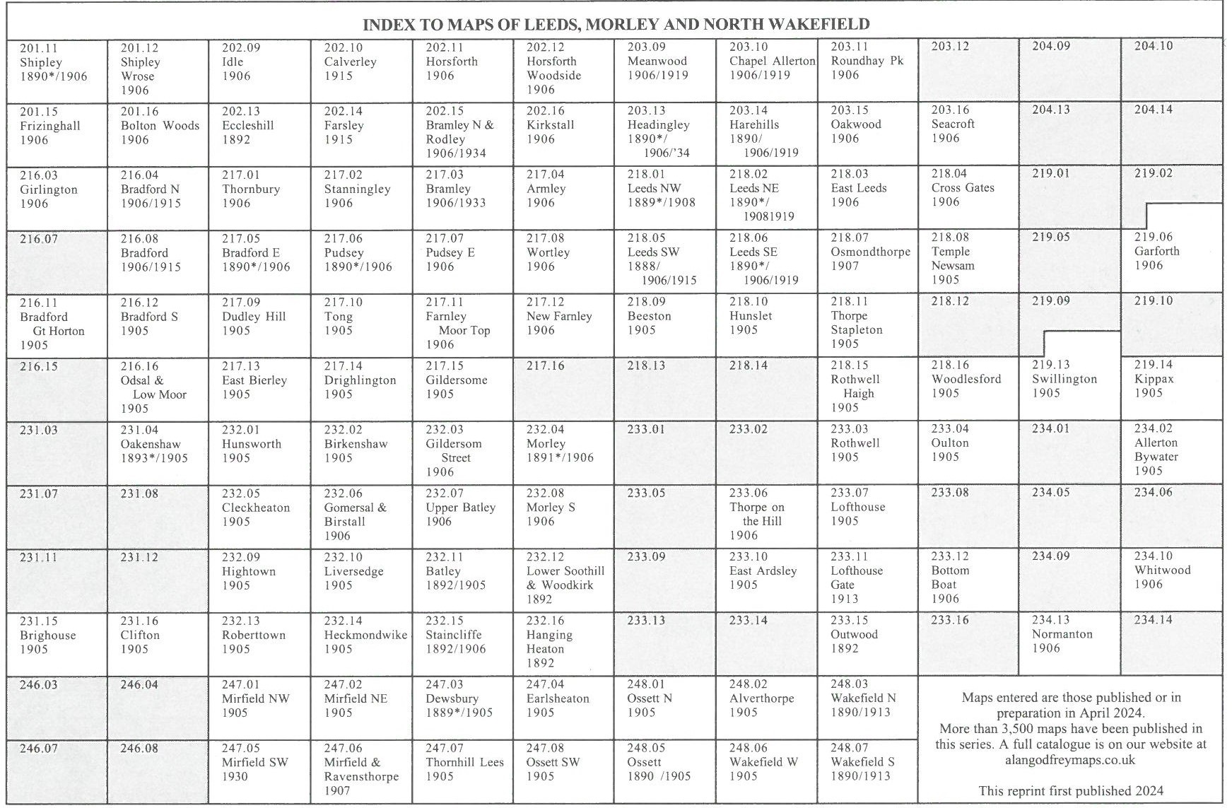
The following index map might also be useful: Leeds index map
 The following maps are taken from the highly detailed Five-foot plans, and reduced to a scale of A Yard to the Mile.
They show the area in even greater detail.
The following maps are taken from the highly detailed Five-foot plans, and reduced to a scale of A Yard to the Mile.
They show the area in even greater detail.
Leeds 10 Leeds (Town Hall & Park Square) 1847-63 - published 2006; intro by G C Dickinson
Leeds 11 Leeds (Headrow) 1847 - published 2005; intro by G C Dickinson
Leeds 12 Leeds (Marsh Lane & Mabgate) 1847 - publ 2024; intro by Alan Godfrey
Leeds 14 Leeds Stations 1847-63 - published 2005; intro by John Gough
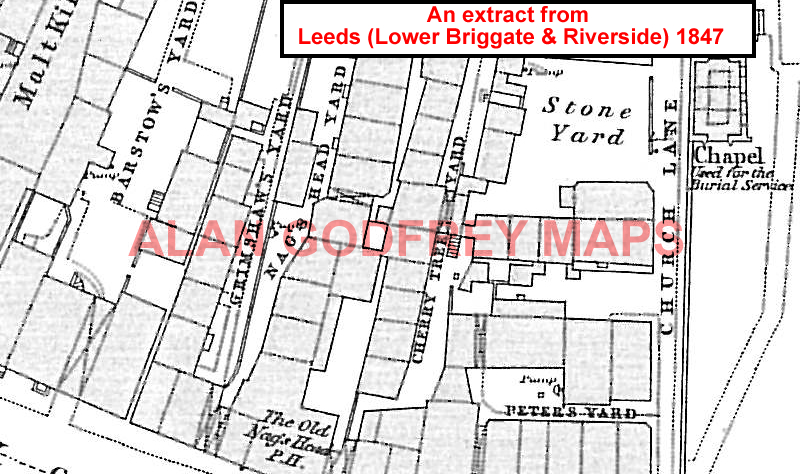
Leeds 15 Leeds (Lower Briggate & Riverside) 1847 - publ 2005; intro by G C Dickinson
Leeds 18 Holbeck 1847 - publ 2024; intro by Alan Godfrey
Leeds 19 Leeds (Pottery Field) 1847 - publ 2009; intro by Suzanne Grahame
The following index map might also be useful: Leeds town plans index map

 There is also an Inch to the Mile map which covers much of the Leeds area:
Sheet 70 Leeds, Wetherby & District 1910.
For further details of our One Inch Maps, visit the One Inch page.
Most maps in the Godfrey Edition are taken from the 25 inch to the mile map and reduced to about 15 inches to the mile.
They cost just £ 3.50 each (Coloured editions £ 4.00). For a full list of English maps, return to the England page
You can order maps direct from our On-line Mapshop.
Alan Godfrey Maps, Prospect Business Park, Leadgate, Consett, DH8 7PW. Tel 01207 583388
The Godfrey Edition / sales@alangodfreymaps.co.uk / 15 April 2025
 The following maps are taken from the highly detailed Five-foot plans, and reduced to a scale of A Yard to the Mile.
They show the area in even greater detail.
The following maps are taken from the highly detailed Five-foot plans, and reduced to a scale of A Yard to the Mile.
They show the area in even greater detail.