
 Here are the details of maps for Shooters Hill:

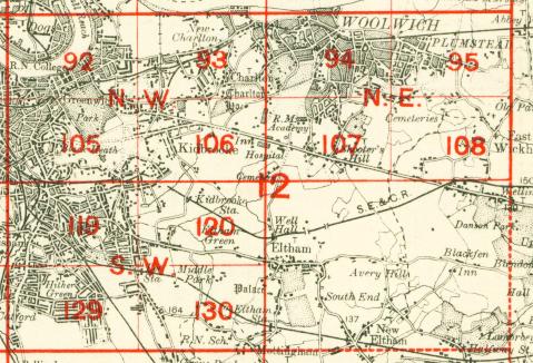
We have published three versions of this map, showing how the area developed across the years. It covers an area stretching from the Brook Hospital eastward to Oxleas Wood and Woodlands Farm; from Genesta Road, Plumstead southward to Severndroog Castle. The map is therefore dominated by the old Roman Road, now largely followed by Shooters Hill Road. Other features include Herbert Hospital, Shrapnel Barracks, Royal Military Academy, tramways, and some of the southern streets of Woolwich and Plumstead, including part of Herbert Road, Cantwell Road and Woolwich Common.
The 1866 map has another map on the reverse. This is the six-inch to the mile map, Kent Sheet 2sw of 1894, giving a good picture of a wider area, including Charlton, Kidbroke, Woolwich and part of Plumstead. The 1894 and 1914 maps have extracts from street directories.
The map links up with Sheets 94 Woolwich to the north, 106 Kidbrooke to the west, and 108 East Wickham & Welling to the east.
 Follow this link for a complete list of our London maps .