
 Here are the details of maps for Kidbrooke & Blackheath:

We have published two versions of this map, showing how the area developed across the years. The maps each cover the same area, stretching from The Paragon eastward to the Brook Hospital (which is right on the margin of the map); and from Lyvedon Road southward to Kidbrooke Green. The map therefore covers the eastern part of Blackheath village, much of Shooters Hill Road, and the northern part of Kidbrooke. Features include Morden College, St James church, St Nicholas church site, Blackheath & Charlton Cottage Hospital, St John's church, Old Dover Road, St John's Road, Royal Horse Infirmary (Remount Depot No.2 on the 1914 map). The 1914 version includes street directories for Blackheath Park, Kidbrooke Grove, Kidbrooke Park Road, Liskeard Gardens, Old Dover Road, The Paragon, St Johns Park, Shooters Hill Road. However the 1894 map has a bonus on the reverse for it includes about half of the 1st Edition 1867 map. If you are buying just one version we therefore recommend the 1894 map as providing extra good value.
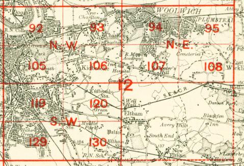
The map links up with London Sheets 93 Charlton to the north, 105 Blackheath to the west, 107 Shooters Hill to the east, 120 Eltham to the south.
 Follow this link for a complete list of our London maps .