
Old Ordnance Survey Maps of Furness
We have a range of detailed maps for the Furness towns and we also cover the whole of Lancashire at the Inch to the Mile scale. Here are the details.
All maps are available from our On-line Mapshop.
Since 1974 this area has been part of Cumbria. See This page for a summary of its local government history.
The following maps are all taken from the OS 25" maps and reduced to a scale of approximately 15 inches to the mile.
They are extremely detailed, showing individual houses, details such as railway tracks, pathways,
pubs, factories and even minutiae such as fountains and signal posts. Each map includes an introduction.
 These are the maps we publish for towns in 'Lancashire over the Water':
16.03 Ulverston 1911 - published 1992; introduction by John Marsh
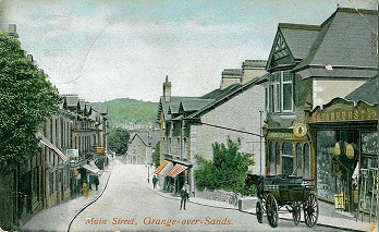
17.04 Grange over Sands 1910 - published 2002; intro by Alan Crosby
21.04 Furness Abbey 1931 - published 2005; intro by Alan Godfrey
21.07 Barrow in Furness (NW) 1911 - published 1991; intro by Ron Smith
21.08 Barrow in Furness (NE) 1911 - published 1991; intro by Ron Smith
21.11 Barrow in Furness (West) 1908 - published 1991; intro by Ron Smith
21.12 Barrow in Furness (East) 1908 - published 1991; intro by Ron Smith
21.15 Barrow in Furness (South) 1908 - published 1991; intro by Ron Smith
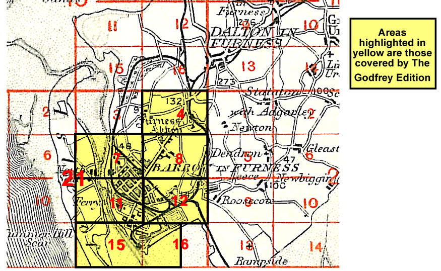
You might find this index map useful.
We also cover the area in our Inch to the Mile series. Here are the principal sheets:
38 Coniston & Ambleside 1895 - published 2011; intro by Derrick Pratt. Includes a map of Coniston..
48 North Furness 1896- published 2002; intro by Alan Crosby. Includes a large scale map of Cartmel.
49 Kirkby Lonsdale & District 1876- published 2002; intro by Paul Hindle. Includes a large scale map of Beetham
58 Barrow-in-Furness & Walney Island 1896- published 2005; intro by Alan Godfrey. Includes a large scale map of Stank.
See the One Inch page for further details of the Inch to the Mile maps.
 Most maps in the Godfrey Edition are taken from the 25 inch to the mile map and reduced to about 15 inches to the mile.
For a full list of English maps, return to the England page
You can order maps direct from our On-line Mapshop.
Most maps in the Godfrey Edition are taken from the 25 inch to the mile map and reduced to about 15 inches to the mile.
For a full list of English maps, return to the England page
You can order maps direct from our On-line Mapshop.
Alan Godfrey Maps, Prospect Business Park, Leadgate, Consett, DH8 7PW. Tel 01207 583388
The Godfrey Edition / sales@alangodfreymaps.co.uk / 15 January 2018
 These are the maps we publish for towns in 'Lancashire over the Water':