
Old Ordnance Survey Maps of Barnsley MBC
This is our coverage of Barnsley, historically part of the West Riding of Yorkshire. Today's Metropolitan Borough of Barnsley was formed in 1974 with the amalgamation of
the County Borough of Barnsley, Cudworth Urban District, Darfield Urban District, Darton Urban District, Dearne Urban District, Dodworth Urban District,
Hoyland Nether Urban District, Penistone Urban District, Royston Urban District, Wombwell Urban District, Worsborough Urban District, Penistone Rural District,
and some outlying parishes. At the same time it became part of the new South Yorkshire Metropolitan County. Since 1986 it has been a unitary authority.
All maps are available from our On-line Mapshop.
The following titles are taken from the OS 25" maps and reduced to a scale of approximately 14 inches to the mile.
They are extremely detailed, showing individual houses, details such as railway tracks, pathways,
pubs, factories and even minutiae such as fountains and signal posts. Each covers an area of a mile and a half by one mile, and includes an introduction.
These are the maps for Barnsley in our Yorkshire series:
262.12 Royston 1904 - published 2009; intro by Alan Godfrey
263.13 Carlton Main 1914 - published 2006; intro by Alan Godfrey
273.15 Penistone & Thurlstone 1903 - published 1999; intro by David Hey
274.04 Monk Bretton & Smithies 1904 - published 2013; intro by Melvyn Jones
274.07 Barnsley 1890 - published 2012; intro by Melvyn Jones  274.07 Barnsley 1904 - published 1986; intro by Harold Taylor
274.08 Barnsley (NE) 1904 - published 1990; intro by Gordon Dickinson
274.10 Dodworth 1904 - published 2001; intro by Melvyn Jones
274.11 Barnsley South 1904 - published 1990; intro by Gordon Dickinson
274.12 Barnsley (SE) 1904 - published 1991; intro by Gordon Dickinson
274.16 Worsborough Dale & Worsborough Bridge 1904 - published 2001; intro by Melvyn Jones
275.01 Cudworth 1904 - published 2006; intro by Alan Godfrey
275.02 Grimethorpe 1929 - published 2005; intro by Melvyn Jones
275.13 Wombwell (NW) & Mitchell Main 1904 - published 2004; intro by Melvyn Jones
275.14 Darfield & Wombwell (North) 1904 - published 2003; intro by Melvyn Jones
281.12 Stocksbridge 1903 - published 2001; intro by David Hey
282.08 Hoyland Nether & Hoyland Common 1903 - published 2002; intro Melvyn Jones
283.02 Wombwell (South) & Lundhill 1901 - published 2003; intro by Melvyn Jones
283.04 Bolton upon Dearne 1901 - published 2012; intro by Melvyn Jones
283.05 Elsecar 1901 - published 2003; intro by Melvyn Jones
283.07 Wath upon Dearne 1901 - published 1988; intro by Alex Fleming
283.08 Manvers Main 1901 - published 1993; intro by Alex Fleming
274.07 Barnsley 1904 - published 1986; intro by Harold Taylor
274.08 Barnsley (NE) 1904 - published 1990; intro by Gordon Dickinson
274.10 Dodworth 1904 - published 2001; intro by Melvyn Jones
274.11 Barnsley South 1904 - published 1990; intro by Gordon Dickinson
274.12 Barnsley (SE) 1904 - published 1991; intro by Gordon Dickinson
274.16 Worsborough Dale & Worsborough Bridge 1904 - published 2001; intro by Melvyn Jones
275.01 Cudworth 1904 - published 2006; intro by Alan Godfrey
275.02 Grimethorpe 1929 - published 2005; intro by Melvyn Jones
275.13 Wombwell (NW) & Mitchell Main 1904 - published 2004; intro by Melvyn Jones
275.14 Darfield & Wombwell (North) 1904 - published 2003; intro by Melvyn Jones
281.12 Stocksbridge 1903 - published 2001; intro by David Hey
282.08 Hoyland Nether & Hoyland Common 1903 - published 2002; intro Melvyn Jones
283.02 Wombwell (South) & Lundhill 1901 - published 2003; intro by Melvyn Jones
283.04 Bolton upon Dearne 1901 - published 2012; intro by Melvyn Jones
283.05 Elsecar 1901 - published 2003; intro by Melvyn Jones
283.07 Wath upon Dearne 1901 - published 1988; intro by Alex Fleming
283.08 Manvers Main 1901 - published 1993; intro by Alex Fleming
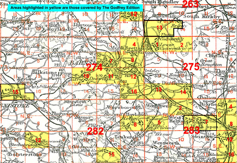
The following index map might also be useful: Barnsley index map
We also publish a series of small scale Inch to the Mile maps covering most of the country. The following is the principal sheet for the area:
87 Dearne Valley & Barnsley 1908-13 - published 2001; intro by Melvyn Jones. Includes a map of Grimethorpe.
For further details of our One Inch Maps, visit the One Inch page.
 Most maps in the Godfrey Edition are taken from the 25 inch to the mile map and reduced to about 15 inches to the mile.
For a full list of Yorkshire maps, return to the Yorkshire page
You can order maps direct from our On-line Mapshop.
Most maps in the Godfrey Edition are taken from the 25 inch to the mile map and reduced to about 15 inches to the mile.
For a full list of Yorkshire maps, return to the Yorkshire page
You can order maps direct from our On-line Mapshop.
Alan Godfrey Maps, Prospect Business Park, Leadgate, Consett, DH8 7PW. Tel 01207 583388
The Godfrey Edition / sales@alangodfreymaps.co.uk / 28 January 2018