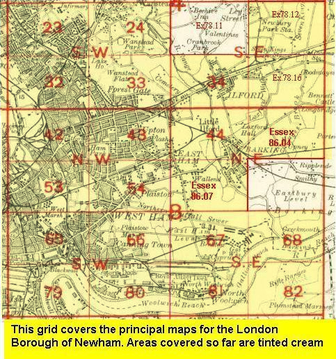
Old Ordnance Survey Maps of Newham
We have excellent coverage for the London Borough of Newham, which was formed in 1965 from the two County Boroughs of East Ham and West Ham, plus the North Woolwich part of the former Municipal Borough of Woolwich. The area includes maps
from both our London and Essex series, which link up with each other. All maps are available from our On-line Mapshop.
The following titles are all taken from the OS 25" maps and reduced to a scale of approximately 14 inches to the mile.
They are extremely detailed, showing individual houses, details such as railway tracks, pathways,
pubs, factories and even minutiae such as fountains and signal posts. Each covers an area of a mile and a half by one mile,
and includes an introduction.
 These are the principal maps for Newham in our London series:
32.1 Leyton 1863-67 - published 2007; intro by Alan Godfrey.
32.2 Leyton 1894 - published 1985; intro by Jonathan Evans
32.3 Leyton 1914 - published 1992; intro by Isobel Watson
33.2 Wanstead Flats 1893 - published 1986; intro by Janice Brooker
33.3 Wanstead Flats 1915 - published 1992; intro by Isobel Watson
34.2 Ilford 1894 - published 1992; intro by Stephen Pewsey
42.1 Stratford 1867 - published 2002; intro by David Mander
42.2 Stratford 1893 - published 1984, 2nd edition 2018; intros by Howard Bloch and Isobel Watson.
42.3 Stratford 1914 - published 1991, 2nd edition 2016; intro by Alan Godfrey
43.1 Upton, Plashet & Forest Gate 1867 - published 2006; intro by Tony Clifford
43.2 Forest Gate 1894 - published 1986; intro by Janice Brooker
43.3 Forest Gate 1915 - published 2019; intro by Alan Godfrey
43.4 Forest Gate 1939 - published 2020; intro by Tony Kirby
44.2 East Ham & Barking 1894 - published 1996; intro by Stephen Pewsey
44.3 East Ham & Barking 1915 - published 1999; intro by Tony Clifford
53.1 Bow, Bromley & West Ham 1867 - published 2007; intro by Isobel Watson
53.2 Bow, Bromley & West Ham 1893 - published 1991; intro by Isobel Watson
53.3 Bow, Bromley & West Ham 1914 - published 1992; intro by Isobel Watson
54.1 Plaistow 1867 - published 2005; intro by Alan Godfrey
54.2 Plaistow 1894 - published 1986; intro by Janice Brooker
54.3 Plaistow 1914 - published 2010; intro by Alan Godfrey
54.34Plaistow 1939 - published 2020; intro by Tony Kirby
65.1 Poplar & Canning Town 1867 - published 2001; intro by Alan Godfrey
65.2 Poplar 1894 - published 2001; intro by Isobel Watson
65.3 Poplar 1914 - published 1990; intro by Isobel Watson
66.1 Custom House & Plaistow Marsh 1867 - published 2005; intro by Alan Godfrey
66.2 Canning Town & Custom House 1894 - published 1986; intro by Stephen Pewsey
66.3 Canning Town & Custom House 1914 - published 1994; intro by Stephen Pewsey
67.2 Beckton 1894 - published 1987; intro by Stephen Pewsey
67.3 Beckton 1914 - published 2000; intro by Tony Clifford
68.2 Creekmouth 1894 - published 1989; intro by Stephen Pewsey
68.3 Creekmouth 1914 - published 2000; intro by Tony Clifford
 79.1 West India Docks 1867 - published 1991; intro by Oliver Harris
79.1 West India Docks 1894 - published 2000; intro by Alan Godfrey
79.1 West India Docks 1914 - published 1991; intro by David Mander
80.1 Silvertown 1867 - published 2006; intro by Alan Godfrey
80.2 Silvertown 1893 - published 1986; intro by Howard Bloch
80.3 Silvertown 1914 - published 2016; intro by Barrie Trinder
81.1 North Woolwich 1869 - published 1986; intro by Howard Bloch
81.2 North Woolwich 1894 - published 1988; intro by Howard Bloch
81.3 North Woolwich 1914 - published 2016; intro by Barrie Trinder
79.1 West India Docks 1867 - published 1991; intro by Oliver Harris
79.1 West India Docks 1894 - published 2000; intro by Alan Godfrey
79.1 West India Docks 1914 - published 1991; intro by David Mander
80.1 Silvertown 1867 - published 2006; intro by Alan Godfrey
80.2 Silvertown 1893 - published 1986; intro by Howard Bloch
80.3 Silvertown 1914 - published 2016; intro by Barrie Trinder
81.1 North Woolwich 1869 - published 1986; intro by Howard Bloch
81.2 North Woolwich 1894 - published 1988; intro by Howard Bloch
81.3 North Woolwich 1914 - published 2016; intro by Barrie Trinder
 Part of Newham is also covered in our Essex series:
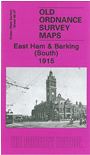
86.07n East Ham & Barking (South) 1915 - published 2007; intro by Tony Clifford & Alan Godfrey. ISBN.978-1-84784-081-3
 Most maps in the Godfrey Edition are taken from the 25 inch to the mile map and reduced to about 15 inches to the mile.
For a full list of English maps, return to the England page
You can order maps direct from our On-line Mapshop.
This list shows all our maps for the borough. We try to keep a full range in print but inevitably some titles fall out of print from time to time.
These are noted in our On-line Mapshop.
Most maps in the Godfrey Edition are taken from the 25 inch to the mile map and reduced to about 15 inches to the mile.
For a full list of English maps, return to the England page
You can order maps direct from our On-line Mapshop.
This list shows all our maps for the borough. We try to keep a full range in print but inevitably some titles fall out of print from time to time.
These are noted in our On-line Mapshop.
Alan Godfrey Maps, Prospect Business Park, Leadgate, Consett, DH8 7PW. Tel 01207 583388
The Godfrey Edition / sales@alangodfreymaps.co.uk / 21 February 2020