
 Here are the details of maps for Poplar:

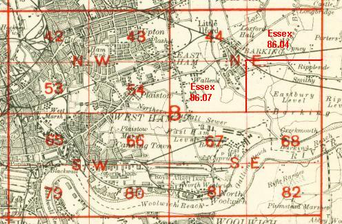
We have published three versions of this map, showing how the area developed across the years. The maps each cover the same area, stretching from Upper North Street at Poplar eastward to Rathbone Street at Canning Town; and from Empson Street and Bromley Gasworks southward to Poplar High Street and Blackwall station. The maps are therefore very busy ones, covering much of Poplar and south Bromley west of the River Lea and part of Canning Town to the east. Features on the maps include the East India Dock, Bow Creek, Bromley Marsh, Thames Iron Works, a stretch of the North London Railway with Poplar station, Poplar Gas Works, GER Wharf, Thames Plate Glass Works, Victoria Dock Road, Limehouse Cut, East India Dock Road, West Marsh, tramways, Brunswick Road, a stretch of the GER Woolwich line, with Canning Town station, Poplar Workhouse, Glasshouse Wharf, and many streets of packed housing. Each map includes extracts from street directories.
The map links up with London Sheets 53 Bow to the north, 64 Stepney to the west, 66 Canning Town to the east, 79 West India Docks to the south.
 Follow this link for a complete list of our London maps .