
 Here are the details of maps for East Ham & Barking (S):

This detailed map fills an important gap in the series, linking the London and Essex groups. Coverage stretches from Ladysmith Avenue eastward to St Mary's Road Barking, and from Caledon Road southward to Norman Road. Features include the municipal centre of East Ham, with Town Hall, Central Hall, tram depot, Baths and Technical College; to the east is part of Barking town centre, including the Abbey ruins and St Margaret's church. Other features include tramways, incl that over Barking Creek; River Roding, sewage works, Jews Cemetery, Central Park, St Bartholomew's church, Wallend, Barking Road Recreation Ground, and the swathe of new streets developed either side of East Ham High Street South. On the reverse are the private resident lists for East Ham and Barking from a 1922 directory.
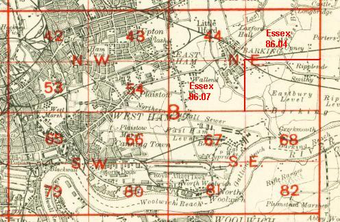
An index map showing the areas covered by this and adjacent maps is available here
The map links up with London Sheets 44 East Ham & Barking to the north, 54 Plaistow to the west,
Beckton to the south, 86.08 Barking SE to the east.