Old Ordnance Survey One-Inch Maps


These maps are taken from the famous OS "Inch to the Mile" Maps. Though obviously far less detailed than the large scale maps for which we are perhaps better known, they provide an invaluable overview of a wider area, typically 18 miles across by 12 miles down. For transport historians they are invaluable for showing old railways, while all historians need them for their close depiction of topography, including parish boundaries. These maps also mean that we can offer historical coverage for small villages where a large scale map would not be commercially viable. We intend to publish the whole of England and Wales in this series. Almost 200 titles are now available and we aim to publish three new titles each month. The maps include historical notes and all (except the double-sided Tyneside title) also include a large scale map of a small town or village in the area.

The maps are neatly folded and each includes a specially written introduction to the area. Maps can be purchased on our On-line Mapshop where further information about titles is given. Visit the One Inch Page for a full list of Inch to the Mile Maps, or The Index Page for a full list to the series and details of Prices.

Here is information about Sheet 255:

  • One Inch Sheet 255 South Chilterns 1886 - published 1997; introduction by Elizabeth Lockwood

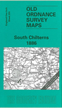
    This early Inch to the Mile map covers the southern part of Buckinghamshire, with small portions of Berkshire, Hertfordshire and Middlesex also coming onto the map. Coverage stretches from Hurley and West Wycombe eastward to Ruislip, and from Sarratt and Little Missenden southward to Maidenhead. Features on this leafy map include Burnham Beeches, Shardeloes, Cassiobury Park, Penn Wood. The Metropolitan Railway has not yet arrived, apart from the Watford & Rickmansworth Railway. Further west the only line to High Wycombe is that from Maidenhead. On the reverse we include an extract from Bucks Sheet 48.07 covering Chalfont St Peter, with an early directory.


    It is not possible to list the many hamlets, farmsteads and other topographical features shown on these maps. However, you may find it useful if we list the towns and principal villages or church parishes that are included on this map. Links are given for those for which detailed large-scale maps are also available.

  • Berkshire: Cookham, Hurley, Maidenhead.
  • Buckinghamshire: Amersham, Beaconsfield, Bradenham, Burnham, Chalfont St Giles, Chalfont St Peter, Chenies, Chesham Bois, Denham, Farnham Royal, Great Marlow, Hedgerley, Hedsor, High Wycombe, Iver, Little Marlow, Little Missenden, Penn, Stoke Poges, Taplow, West Wycombe, Wexham, Wooburn.
  • Hertfordshire: Chorleywood, Rickmansworth, Sarratt.
  • Middlesex: Cowley, Harefield, Hayes, Hillingdon, Ickenham, Ruislip, Uxbridge.

    For a full list of Inch to the Mile maps go to the One Inch Page; or for a fuller list of local maps go to the Buckinghamshire page.

    You can order maps direct from our On-line Mapshop. For other information and prices, and other areas, go to The Index Page.


    The Godfrey Edition / godfreyedition@btinternet.com / 31 January 2006