
Old Ordnance Survey Maps of Liverpool
This is our coverage of the City of Liverpool. Liverpool, historically in Lancashire, was a borough in the 13th century. It became a City in 1880 and a County Borough in 1889.
In 1974 it was reincorporated as a Metropolitan Borough in the new metropolitan county of Merseyside.
All maps are available from our On-line Mapshop.
The following titles are taken from the OS 25" maps and reduced to a scale of approximately 14 inches to the mile.
They are extremely detailed. Each covers an area of a mile and a half by one mile, and includes an introduction.
 These are the City of Liverpool maps in our Lancashire series. Some outlying areas are also included:
099.09a Waterloo & Seaforth 1907 - published 2023; intro by Kay Parrott
099.09b Waterloo & Seaforth 1925 - published 2003; intro by Jennifer Lewis
099.10 Litherland (East) 1906 - published 2017; intro by Kay Parrott
099.11 Aintree 1906 - published 1998; intro by Kay Parrott
099.13 Bootle Docks 1907 - published 1989; intro by Mike Greatbatch
099.14 Bootle (North) 1906 - published 2000; intro by Mike Greatbatch
099.15 Fazakerley 1906 - published 1998; intro by Naomi Evetts
106.02a Bootle 1890 - published 2019; intro by Kay Parrott  106.02b Bootle 1907 - published 1989; intro by Mike Greatbatch
106.03 Walton on the Hill 1906 - published 1997; intro by Kay Parrott
106.04 Croxteth Hall 1906 - published 2002; intro by Kay Parrott
106.06a Kirkdale 1890 - published 2018; intro by Kay Parrott
106.06b Kirkdale 1906 - published 1997; intro by Naomi Evetts
106.07a Anfield 1890 - published 2020; intro by Kay Parrott
106.07b Anfield 1908 - published 1994; intro by Naomi Evetts
106.08 West Derby 1906 - published 1995; intro by Kay Parrott
106.10a Liverpool (North) 1890 - published 2015; intro by Kay Parrott
106.10b Liverpool (North) 1906 - published 1990; intro by Naomi Evetts
106.10c Liverpool (North) 1924 - published 2023; intro by Alan Godfrey
106.11 Liverpool (Newsham Park) 1905 - published 1991; intro by Kay Parrott
106.12a Knotty Ash & Old Swan 1906 - published 1993; intro by Kay Parrott
106.12b Knotty Ash & Old Swan 1925 - published 2026; intro by Kay Parrott
106.14a Central Liverpool 1890 - published 2011; intro by Kay Parrott
106.14b Central Liverpool 1906 - published 1989; intro by Kay Parrott
106.14c Central Liverpool 1924 - published 2021; intro by Kay Parrott
106.15a Edge Hill 1905 - published 1989; intro by Kay Parrott
106.15b Edge Hill 1925 - published 2022; intro by Kay Parrott
106.16a Wavertree & Broadgreen 1905 - published 1989; intro by Kay Parrott
106.16b Wavertree & Broadgreen 1925 - published 1023; intro by Kay Parrott
107.09 Roby & Dovecot 1906 - published 2014; intro by Kay Parrott
107.13 Childwall & Court Hey 1906 - published 2014; intro by Kay Parrott
113.02a Toxteth 1890 - published 2015; intro by Kay Parrott
113.02b Toxteth 1908 - published 1989; intro by Naomi Evetts
113.02c Toxteth 1924 - published 2022; intro by Kay Parrott
113.03a Liverpool (Princes Park) 1905 - published 1991; intro by Naomi Evetts
113.03b Liverpool (Princes Park) 1924 - published 2022; intro by Kay Parrott
113.04 Allerton 1905 - published 1990; intro by Kay Parrott
113.07a St Michaels & Aigburth Vale 1908 - published 1989; intro by Naomi Evetts
113.07b St Michaels & Aigburth Vale 1924 - published 2022; intro by Kay Parrott
113.08a Mossley Hill 1905 - published 1992; intro by Naomi Evetts
113.08b Mossley Hill 1925 - published 2023; intro by Kay Parrott
113.12a Garston 1891 - published 2020; intro by Alan Godfrey
113.12b Garston 1904 - published 2000; intro by Kay Parrott
113.16a Speke & Garston Docks 1890 - published 2021; intro by Kay Parrott
113.16b Speke & Garston Docks 1905 - published 1996; intro by Nick Burton
114.01 Gateacre 1904 - published 2000; intro by Kay Parrott
114.05 Woolton 1904 - published 1997; intro by Kay Parrott
114.06 Halewood 1904 - published 2000; intro by Kay Parrott
114.09 Hunt's Cross & Allerton Hall 1904 - published 2016; intro by Kay Parrott
106.02b Bootle 1907 - published 1989; intro by Mike Greatbatch
106.03 Walton on the Hill 1906 - published 1997; intro by Kay Parrott
106.04 Croxteth Hall 1906 - published 2002; intro by Kay Parrott
106.06a Kirkdale 1890 - published 2018; intro by Kay Parrott
106.06b Kirkdale 1906 - published 1997; intro by Naomi Evetts
106.07a Anfield 1890 - published 2020; intro by Kay Parrott
106.07b Anfield 1908 - published 1994; intro by Naomi Evetts
106.08 West Derby 1906 - published 1995; intro by Kay Parrott
106.10a Liverpool (North) 1890 - published 2015; intro by Kay Parrott
106.10b Liverpool (North) 1906 - published 1990; intro by Naomi Evetts
106.10c Liverpool (North) 1924 - published 2023; intro by Alan Godfrey
106.11 Liverpool (Newsham Park) 1905 - published 1991; intro by Kay Parrott
106.12a Knotty Ash & Old Swan 1906 - published 1993; intro by Kay Parrott
106.12b Knotty Ash & Old Swan 1925 - published 2026; intro by Kay Parrott
106.14a Central Liverpool 1890 - published 2011; intro by Kay Parrott
106.14b Central Liverpool 1906 - published 1989; intro by Kay Parrott
106.14c Central Liverpool 1924 - published 2021; intro by Kay Parrott
106.15a Edge Hill 1905 - published 1989; intro by Kay Parrott
106.15b Edge Hill 1925 - published 2022; intro by Kay Parrott
106.16a Wavertree & Broadgreen 1905 - published 1989; intro by Kay Parrott
106.16b Wavertree & Broadgreen 1925 - published 1023; intro by Kay Parrott
107.09 Roby & Dovecot 1906 - published 2014; intro by Kay Parrott
107.13 Childwall & Court Hey 1906 - published 2014; intro by Kay Parrott
113.02a Toxteth 1890 - published 2015; intro by Kay Parrott
113.02b Toxteth 1908 - published 1989; intro by Naomi Evetts
113.02c Toxteth 1924 - published 2022; intro by Kay Parrott
113.03a Liverpool (Princes Park) 1905 - published 1991; intro by Naomi Evetts
113.03b Liverpool (Princes Park) 1924 - published 2022; intro by Kay Parrott
113.04 Allerton 1905 - published 1990; intro by Kay Parrott
113.07a St Michaels & Aigburth Vale 1908 - published 1989; intro by Naomi Evetts
113.07b St Michaels & Aigburth Vale 1924 - published 2022; intro by Kay Parrott
113.08a Mossley Hill 1905 - published 1992; intro by Naomi Evetts
113.08b Mossley Hill 1925 - published 2023; intro by Kay Parrott
113.12a Garston 1891 - published 2020; intro by Alan Godfrey
113.12b Garston 1904 - published 2000; intro by Kay Parrott
113.16a Speke & Garston Docks 1890 - published 2021; intro by Kay Parrott
113.16b Speke & Garston Docks 1905 - published 1996; intro by Nick Burton
114.01 Gateacre 1904 - published 2000; intro by Kay Parrott
114.05 Woolton 1904 - published 1997; intro by Kay Parrott
114.06 Halewood 1904 - published 2000; intro by Kay Parrott
114.09 Hunt's Cross & Allerton Hall 1904 - published 2016; intro by Kay Parrott
Here is an Index Map for our Liverpool maps.
We also publish some more detailed Town plans, taken from the 5 feet to the mile maps, and reduced in scale to
a Yard to the Mile (or 1:1760). These show Liverpool City Centre in the mid 19th century. See here for details.
We also publish a series of smaller scale Inch to the Mile maps. Liverpool is covered by the following map:
96 Liverpool & The Wirral 1904 - published 2003; intro by Derrick Pratt
For full details of this series visit the One Inch page.
 Most maps in the Godfrey Edition are taken from the 25 inch to the mile map and reduced to about 15 inches to the mile.
For a full list of North West maps, return to the North West page
Most maps in the Godfrey Edition are taken from the 25 inch to the mile map and reduced to about 15 inches to the mile.
For a full list of North West maps, return to the North West page
Alan Godfrey Maps, Prospect Business Park, Leadgate, Consett, DH8 7PW. Tel 01207 583388
The Godfrey Edition / sales@alangodfreymaps.co.uk / 12 February 2026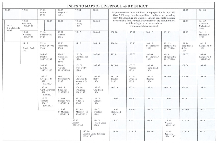