
Old Ordnance Survey Maps of Hartlepool
These detailed maps normally cover an area of about one and a half miles by one mile. Each map includes an introduction.
They are available through our On-line Mapshop
 Here are the details of maps for West Hartlepool:
Co Durham Sheet 37.11 West Hartlepool 1857-73 - published 1988; intro by Alan Godfrey. ISBN.978-0-85054-194-6  Co Durham Sheet 37.11 West Hartlepool 1896 - published 1983, 2nd Edition 2014; intro by Alan Godfrey. ISBN.978-1-84784-826-0
Co Durham Sheet 37.11 West Hartlepool 1914 - published 1985, 2nd Edition 2004; intro by John Griffiths. ISBN.978-0-907554-98-1
Co Durham Sheet 37.11 West Hartlepool 1896 - published 1983, 2nd Edition 2014; intro by Alan Godfrey. ISBN.978-1-84784-826-0
Co Durham Sheet 37.11 West Hartlepool 1914 - published 1985, 2nd Edition 2004; intro by John Griffiths. ISBN.978-0-907554-98-1
Three versions of this map are available, showing how the area developed across the years. They cover West Hartlepool - the new town created by Ward Jackson in the
the mid 19th century as a major shipbuilding and coal shipping port. The town developed from the old hamlet of New Stranton. Coverage stretches from Bengal Street eastward to the coast and from Middleton and Central Dock southward to Musgrave Street.
The early 1857 edition shows the town developing around Christ Church and Church Street. Features include Middleton, Jackson Dock, Timber Dock, many coal drops, Harbour Terrace, Albert Square, station (on Mainsforth Terrace),
West Harbour, New Road, gasworks. There is very little development west of Stockton Street. Surveyed in 1857, the map was updated to 1873. Exctracts from an early trade directory are included.
By the 1894 edition development had spread further west and features include Town Hall, York Road area, St Josephs RC church, station (on present site), goods station, Swainson Dock, more timber ponds, graving docks, engine shed, more railways and development around
the docks.
The 1914 version is even more built up and includes St Oswald's church, Victoria football ground, Union Dock, tramways. Extracts from a contemnporary street
directory, including Jackson Street, Middleton Road, Stockton Street, Tower Street, Victoria Road are included.
The map links up with Sheet 37.07 Hartlepool to the north and Stranton to the south.
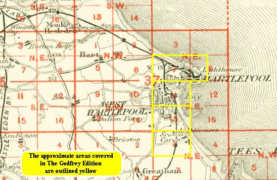
You might find this index map useful.
Follow this link for a complete list of our Hartlepool area maps.
You can order maps direct from our On-line Mapshop.
For other information and prices, and other areas, go to The Index Page.
Maps in the Godfrey Edition are taken from the 25 inch to the mile map and reduced to about 15 inches to the mile.
For a full list of maps for the North East, return to the North East page.
The Godfrey Edition / sales@alangodfreymaps.co.uk / 14 January 2018