Old Ordnance Survey Maps of Stranton


We have published more than 2,000 maps in our series of Old Ordnance Survey Map reprints, including a large group in County Durham, where we are based. The maps are highly detailed. They are taken from the OS 1:2,500 (or 25 inch) maps and reduced to about 15 inches to the mile. Each covers an area of a mile and a half by a mile. They show streets with individual houses, tram tracks, railway tracks and even signals, factories, wharves and such details as fountains and water troughs. They will provide hours of fascination for historians and genealogists. The maps are neatly folded and each includes a specially written introduction to the area. Maps can be purchased on our On-line Mapshop where further information about titles is given. Or visit The Index Page for a full list to the series and details of Prices.


  • Here are the details of maps for Stranton:

  • Co Durham Sheet 37.15 Stranton & southern Hartlepool 1896 - published 1984, 2nd Edition 2006; introduction by Alan Godfrey

    Stranton was the original village for West Hartlepool, though it was quickly eclipsed by the rapidly growing new town in the mid 19th century. This map covers the area from Burbank Street and All Saints church southward to Foggy Furze and Longhill Farm. The various iron and steel works with their railway sidings and furnaces are major features. Other features include the Lion Brewery, Bellevue, St Aidan's church, Hartlepools Paper Works, Baltic Saw Mills, Carr House, Longhill. Street directory entries for Burbank Street, Burn Road, Lister Street, Oxford Street, Stockton Road and Stockton Street are included.

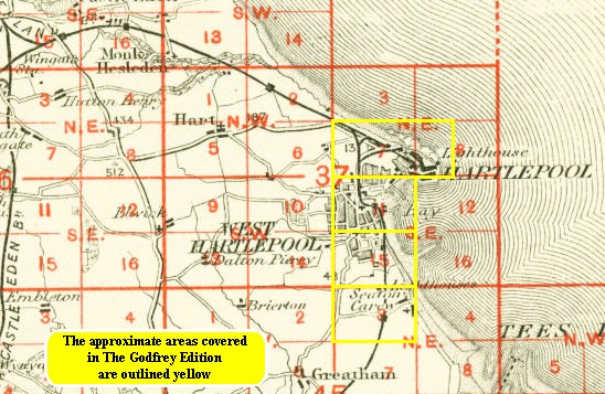
    The map links up with Sheet 37.11 West Hartlepool to the north and 45.03 Seaton Carew to the south.

    You might find this index map useful.


    Follow this link for a complete list of our Hartlepool area maps.

    You can order maps direct from our On-line Mapshop. For other information and prices, and other areas, go to The Index Page.


    Maps in the Godfrey Edition are taken from the 25 inch to the mile map and reduced to about 15 inches to the mile. For a full list of maps for the North East, return to the North East page.

    The Godfrey Edition / godfreyedition@btinternet.com / 28 Oct 2006