
 Here are the details of maps for Thornton Heath:

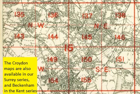
The two maps listed here are from different series, for London and Surrey, and so the sheetlines are somewhat different.
The London series map 149 covers an area from Pollards Hill North at Norbury eastward to Whitehorse Road and Decimus Burton Road at Thornton Heath; and from Beulah Crescent southward to Holmesdale Road and Brigstock Road. Features include Thornton Heath station, New Thornton Heath, and a long stretch of London Road through Norbury; streets at Thornton Heath include High Street, Bensham Manor Road, Beulah Road and others. There is a very good selection of street directory entries on the reverse.
The map links up with London Sheet 144 Norbury to the north, 150 South Norwood to the east, 154 Croydon NW to the south, and Surrey Sheet 14.05 Mitcham Road to the south.
The Surrey sheet 14.02 is centred somewhat further east, although it does overlap considerably with the London map. This later map is more built up, and covers an area from Bridport Road and Beverstone Road eastward to South Norwood Hill and Whitworth Road; and from Beulah Crescent southward to Ecclesbourne Road and Dagnall Park. It therefore covers most of Thornton Heath and part of South Norwood. Features include tramways, Grangewood, Thornton Heath station (enlarged since the earlier map), Falkland Park, Ross Road, Whitehorse Road etc. This map too includes good street directory extracts, listing many of the occupants. It links up with Surrey Sheet 14.06 West Croydon to the south.
 Follow this link for a complete list of our London maps .