
 Here are the details of maps for Paddington:

The three versions of this map show how the area developed across the years. The maps each cover the same area, stretching from Chepstow Place and Leinster Square eastward to Seymour Place and Bryanston Square; from Harrow Road southward to Kensington Gardens. Features include Paddington station and its approaches, Royal Oak and Bishop's Road stations, tramways, Paddington Basin, parts of the Metropolitan/Circle Line, Bayswater, part of Hyde Park. Churches include St Mary's Paddington Green, Christ Church Lancaster Gate, St John's Southwick Crescent, St Mary's Upper York St, etc. The many streets include Westbourne Grove, Praed Street, Edgware Road, Uxbridge Road, Craven Road and many more. Each map also includes extracts from contemporary directories.
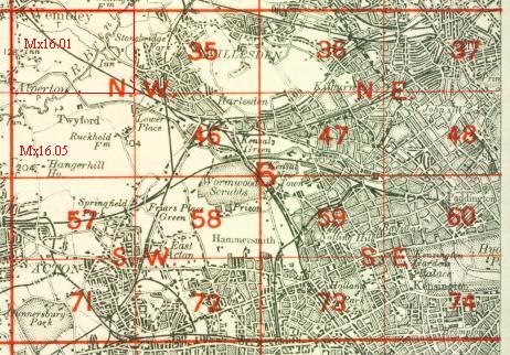
The map links up with Sheet 48 St John's Wood to the north, 59 Notting Hill to the west, 61 The West End to the east and 74 Kensington to the south.
 Follow this link for a complete list of our London maps .