
Old Ordnance Survey Inch to the Mile Maps
These maps normally cover an area of about 18 miles by 12 miles and are especially good at showing railways, roads and canals, and at giving
a broad view of a wider area. Each includes an introduction and a more detailed map of a small town or village.
They are available through our On-line Mapshop
 Here is information about Sheet 224:
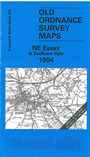
One Inch Sheet 224 NE Essex & Dedham Vale 1904 - published 2005; intro by Robert Malster. ISBN.978-1-84151-761-2
This map covers the area of Essex from Colchester eastward to Harwich, and southward to Frinton; northward it covers the River Stour estuary, and the southern part of
Suffolk as far as Tattingstone. Apart from Colchester itself, the towns on the map are Wivenhoe, Manningtree, Harwich and Walton on the Naze. On the reverse we include a detailed map
of the village of Weeley, complete with directory.
It is not possible to list the many hamlets, farmsteads and other topographical features shown on these maps. However, you may find it useful if we list the towns and
principal villages or church parishes that are included on this map:
Essex: Abberton, Alresford, Ardleigh, Boxted, Bradfield, Brantham, Colchester, Dedham, Dovercourt, Elmstead, Fingringhoe, Frating, Frinton, Great Bentley, Great Bromley, Great Holland,
Great Oakley, Harwich, Kirby-le-Soken, Little Bentley, Little Bromley, Little Clacton, Little Oakley, Manningtree, Pewit Island, Ramsey, Skipper's Island,
Tendring, Thorpe-le-Soken, Thorrington, Walton-on-the-Naze, Weeley, Wivenhoe, Wix, Wrabness.
Suffolk: Brantham, East Bergholt, Erwarton, Harkstead, Higham, Holbrook, Holton St Mary, Horsey Island, Shotley, Stoke by Nayland, Stratford St Mary, Stutton, Tuttingstone.
Index maps are available showing the areas covered by the Inch to the Mile maps. Go to This page
You can order maps direct from our On-line Mapshop. For a full list of Inch to the Mile maps go to the Inch to the Mile page,
where you will also find details of prices. For information on the rest of the series, go to The Index Page.
Alan Godfrey Maps, Prospect Business Park, Leadgate, Consett, Co Durham, DH8 7PW / sales@alangodfreymaps.co.uk / 16 April 2011