
 Here are the details of maps for Nottingham NW:

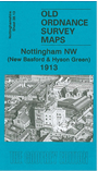
This very detailed map covers the north west area of Nottingham, with coverage stretching from Maud Street and Leslie Road westward to Aspley Hall, and from Bailey Street and Silverdale Road southward to Gregory Boulevard. Hyson Green is in the SE quarter of the map, New Basford in the upper part. Radford Road runs N-S through the map. Features include Whitemoor, Newcastle Colliery, Bobbers Mill, Gladstone Street, Star Brewery, Scotholme Bleaching Works, Maville Chemical Works, lace factories, St Stephens church, New Basford station (in NE corner), gas works. We include street directories for Eland St, Northgate, Radford Road, Rawson St.
The map links up with Notts sheets 38.09 Old Basford to the north, 38.14 Nottingham North to the east, 42.01 Radford to the south.