We have published more than 1,800 maps in our series of Old Ordnance Survey Map reprints, some 300 of them in the London area. The maps are highly detailed. They are taken from the OS 1:2,500 (or 25 inch) maps and reduced to about 15 inches to the mile. They show streets with individual houses, tram tracks, railway tracks and even signals, factories, wharves and such details as fountains and water troughs. They will provide hours of fascination for historians and genealogists. The maps are neatly folded and each includes a specially written introduction to the area. Maps can be purchased on our On-line Mapshop where further information about titles is given. For other information and Prices, see Index Page.
Here are the details of maps for Newbury Park:
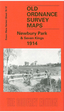
This detailed map covers a northern area of Ilford, including many of the newly developed streets of Seven Kings south of Meads Lane - Pembroke Road, Chester Road, Blythswood Road etc - and the northern tip of Goodmayes, including a railway permanent way depot. Ley Street and Horns Road runs up the western edge of the map, with a tramway depot near Leystreet Farm; in the NW corner of the map is the community of Newbury Park, with its station, and Ilford Emergency Hospital. The large West Ham Lunatic Asylum is in the NE corner. There is a strong contrast between the long, regimented streets of Seven Kings and the countryside off Aldborough Road.
The map links up with Essex Sheet 78.08 Aldborough Hatch to the north, 79.09 Chadwell Heath to the east, and 78.16 Goodmayes to the south; and also74.01 Seven Kings 1894.
Follow this link for a complete list of our London maps or this for a list of the Essex maps.
You can order maps direct from our On-line Mapshop. For other information and Prices, see Index Page.
Maps in the Godfrey Edition are taken from the 25 inch to the mile map and reduced to about 15 inches to the mile. For a full list of maps for London, return to the London page.
The Godfrey Edition / godfreyedition@btinternet.com / 1 Oct 2005