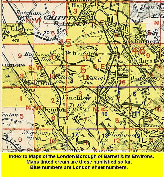
 Here is information about the map for East Barnet:

Our authors tell us that in the 1890s "this area, despite the development of New Barnet to its north, was still both rural and remote. It only became part of suburban London in fact in the 1930s, with the extension of the Piccadilly line to Cockfosters". The map covers an area from Oakleigh Road North eastward to Southgate High Street, and northward to Chelmsford Road. There is a village centre at Southgate on the east side of the map, including Southgate House, several other large houses, Christ Church, and along Chase Side is Osidge. The heart of the map is rural and dominated by the Great Northern Cemetery; the GNR line runs past, partly in tunnel, with the site of the closed cemetery station. In the NW of the map is Colney Hatch Road and St Mary's church, East Barnet.
A backing map, comprising half of Sheet 7.05, continues coverage northward, along Cock Fosters Road, past Oak Hill Park, to the southern fringe of Cockfosters (here Cock Fosters) with Christ Church at the top of the map.
The map links up with Middlesex Sheets 6.08 New Barnet and 6.12 Whetstone to the west, 7.10 Winchmore Hill to the east, 7.13 Friern Barnet to the south.