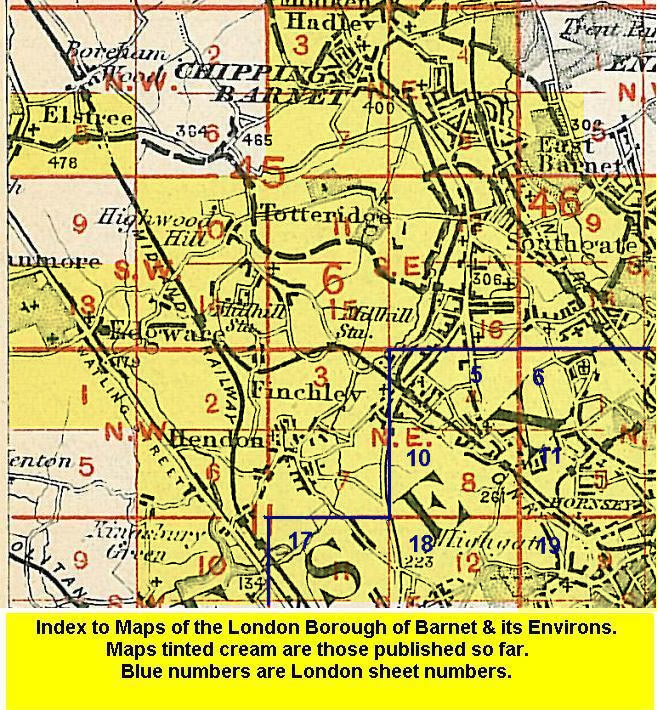
Old Ordnance Survey Maps of Friern Barnet


We have published more than 1,800 maps in our series of Old Ordnance Survey Map reprints, some 300 of them in the London area. The maps are highly detailed. They are taken from the OS 1:2,500 (or 25 inch) maps and reduced to about 15 inches to the mile. They show streets with individual houses, tram tracks, railway tracks and even signals, factories, wharves and such details as fountains and water troughs. They will provide hours of fascination for historians and genealogists. The maps are neatly folded and each includes a specially written introduction to the area. Maps can be purchased on our On-line Mapshop where further information about titles is given. For other information and Prices, see Index Page.


Here are the details of maps for Friern Barnet & New Southgate:

  • Middlesex Sheet 7.13 Friern Barnet & New Southgate 1898 - published 1987; introduction by Pamela Taylor

    The map shows Friern Barnet on the left side and New Southgate on the right of the GNR railway that runs through the map, including the large New Southgate station. The dominant feature is the massive Colney Hatch Asylum, the largest such institution in Europe when it opened in 1851. To its west of it is St John's church, Southgate College, Colney Hatch village and Halliwick Manor House. The map extends northward to Brunswick Park, southward to Bounds Green Farm. Other features include Arnos Grove Wood, Bowes Road, Pymmes Brook, Waterfall Hill, the Clock & Watchmakers Asylum, Friern Barnet Lane, Minchenden Wood. There are directories for Avenue Road, Friern Barnet Road and Oakleigh Road on the reverse.

    An index map showing the areas covered by this and adjacent maps is available here. The map links up with Middlesex Sheets 7.09 East Barnet to the north, 6.16 North Finchley to the west, 7.14 Palmers Green to the east, and London Sheet 6 Alexandra Park to the south.


    Follow this link for a complete list of our London & Middlesex maps .

    You can order maps direct from our On-line Mapshop. For other information and Prices, see Index Page.


    Maps in the Godfrey Edition are taken from the 25 inch to the mile map and reduced to about 15 inches to the mile. For a full list of maps for London, return to the London page.

    The Godfrey Edition / godfreyedition@btinternet.com / 25 August 2005