Hampshire Sheet 83.06 Gosport (West) 1931 - published 2017; intro by Tony Painter. ISBN.978-1-78721-064-6 
This detailed map covers the north west part of Gosport, stretching from Parham Road and Peel Road westward to Fort Brockhurst station.
Features include railway with Fort Brockhurst station and part of Gosport station; stretches of Lee-on-Solent and Stokes Bay branches; Brockhurst area,
HMS St Vincent, Camdentown, Forton, St Luke's church, Thorngate's Almshouses, St Joseph's RC church, cemetery, etc.
The map links up with Hampshire Sheets 83.07 Portsea to the east, 83.10 Alverstoke to the east.
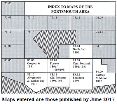
You might find this Index Map useful.
Follow this link for a complete list for Portsmouth maps, or follow these links for the rest of Hampshire, or Isle of Wight.
You can order maps direct from our On-line Mapshop.
For other information and prices, and other areas, go to The Index Page.
Maps in the Godfrey Edition are taken from the 25 inch to the mile map and reduced to about 15 inches to the mile.
For a full list of maps for England, return to the England page.
Alan Godfrey Maps, Prospect Business Park, Leadgate, Consett, Co Durham, DH8 7PW / sales@alangodfreymaps.co.uk / 17 January 2017

 Here are the details of maps for west Gosport: