Old Ordnance Survey Maps of Westmorland
We have a range of detailed maps for Cumbrian towns and we also cover the whole county at the Inch to the Mile scale.
All maps are available from our On-line Mapshop.
Westmorland County Council governed from 1889-1974. Since 1974 the county has been part of Cumbria. See This page for a summary of its local government history.
The following maps are all taken from the OS 25" maps and reduced to a scale of approximately 15 inches to the mile.
They are extremely detailed, showing individual houses, details such as railway tracks, pathways,
pubs, factories and even minutiae such as fountains and signal posts. Each map includes an introduction.
 These are the maps we publish for towns in Westmorland:
15.03 Appleby 1911 - published 1992; intro by Nick Burton
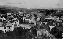
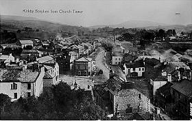
23.15 Kirkby Stephen 1911 - published 2006; intro by Alan Godfrey
32.07 Windermere 1911 - published 2022; intro by Alan Godfrey
32.11 Bowness on Windermere 1911 - published 2022; intro by Alan Godfrey
38.04 Kendal North 1911 - published 1991, 2nd ed 2014; intro by Alan Godfrey
38.08 Kendal 1911 - published 1991, 2nd ed 2014; intro by Alan Godfrey
47.08 Kirkby Lonsdale 1912 - published 2022; intro by Alan Godfrey
We also cover the area in our Inch to the Mile series. These are the principal sheets for Westmorland:
30 Shap, Ullswater & Appleby 1895 - published 2003; intro by Paul Hindle. Includees a map of Long Marton
31 Stainmore 1904- published 2006; intro by David Butler. Includes a map of Brough
38 Coniston & Ambleside 1895 - published 2000; intro by Derrick Pratt. Includes a map of Coniston
39 Central Westmorland 1895 - published 2000; intro by Elizabeth Clutton. Includes a map of Bowness
40 Askrigg, Kirkby Stephen & Upper Swaledale 1904 - published 2008; intro by Barrie Trinder. Includes a map of Askrigg
49 Kirkby Lonsdale & District 1876 - published 2003; intro by Paul Hindle. Includes a map of Beetham
For further details visit the One Inch page.
 Most maps in the Godfrey Edition are taken from the 25 inch to the mile map and reduced to about 15 inches to the mile.
For a full list of English maps, return to the England page
Most maps in the Godfrey Edition are taken from the 25 inch to the mile map and reduced to about 15 inches to the mile.
For a full list of English maps, return to the England page
This list shows all our maps for the county. We try to keep a full range in print but inevitably some titles fall out of print from time to time.
These are noted in our On-line Mapshop.
Alan Godfrey Maps, Prospect Business Park, Leadgate, Consett, DH8 7PW. Tel 01207 583388
The Godfrey Edition / sales@alangodfreymaps.co.uk / 28 Nov 2022
 These are the maps we publish for towns in Westmorland: